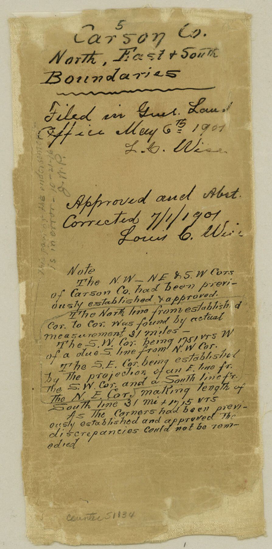
Carson County Boundary File 5 and 5a
Fieldnotes of the County Bdy. Line between Hutchinson and Carson Counties
-
Map/Doc
51134
-
Collection
General Map Collection
-
Counties
Carson
-
Subjects
County Boundaries
-
Height x Width
8.8 x 4.4 inches
22.4 x 11.2 cm
Part of: General Map Collection
Pecos County Rolled Sketch 82

Print $20.00
- Digital $50.00
Pecos County Rolled Sketch 82
1930
Size 28.3 x 25.8 inches
Map/Doc 10191
Starr County Working Sketch 17

Print $20.00
- Digital $50.00
Starr County Working Sketch 17
1982
Size 46.1 x 42.7 inches
Map/Doc 63933
Map of a Part of Robertson Colony

Print $20.00
- Digital $50.00
Map of a Part of Robertson Colony
1843
Size 32.2 x 22.6 inches
Map/Doc 168
Concho County Sketch File 40

Print $26.00
- Digital $50.00
Concho County Sketch File 40
1949
Size 11.3 x 8.7 inches
Map/Doc 19194
Map of Hays County Travis District

Print $20.00
- Digital $50.00
Map of Hays County Travis District
1861
Size 18.6 x 26.0 inches
Map/Doc 3648
Motley County Sketch File 20 (S)

Print $14.00
- Digital $50.00
Motley County Sketch File 20 (S)
Size 7.2 x 8.7 inches
Map/Doc 32196
Flight Mission No. CRK-3P, Frame 66, Refugio County

Print $20.00
- Digital $50.00
Flight Mission No. CRK-3P, Frame 66, Refugio County
1956
Size 18.6 x 22.4 inches
Map/Doc 86908
Wilbarger County Sketch File 18

Print $12.00
- Digital $50.00
Wilbarger County Sketch File 18
1886
Size 14.3 x 8.8 inches
Map/Doc 40209
Dawson County Sketch File 6

Print $72.00
- Digital $50.00
Dawson County Sketch File 6
1927
Size 24.6 x 24.7 inches
Map/Doc 20518
Haskell County

Print $20.00
- Digital $50.00
Haskell County
1933
Size 41.7 x 36.2 inches
Map/Doc 77307
Panola County Rolled Sketch 7

Print $20.00
- Digital $50.00
Panola County Rolled Sketch 7
1957
Size 19.4 x 27.8 inches
Map/Doc 7199
Dickens County Sketch File 22

Print $8.00
- Digital $50.00
Dickens County Sketch File 22
1913
Size 11.2 x 9.1 inches
Map/Doc 20985
You may also like
Caldwell County Working Sketch 12

Print $20.00
- Digital $50.00
Caldwell County Working Sketch 12
1979
Size 47.7 x 44.2 inches
Map/Doc 67842
Map of Kerr County Texas

Print $20.00
- Digital $50.00
Map of Kerr County Texas
1879
Size 20.5 x 28.5 inches
Map/Doc 4575
Carte d'une partie de L'Amérique Séptentrionale, qui contient partie de la Nle. Espagne, et de la Louisiane

Print $20.00
- Digital $50.00
Carte d'une partie de L'Amérique Séptentrionale, qui contient partie de la Nle. Espagne, et de la Louisiane
1782
Size 14.1 x 18.1 inches
Map/Doc 97118
[Leagues 7, 8, 9, and 10]
![92218, [Leagues 7, 8, 9, and 10], Twichell Survey Records](https://historictexasmaps.com/wmedia_w700/maps/92218-1.tif.jpg)
Print $20.00
- Digital $50.00
[Leagues 7, 8, 9, and 10]
1943
Size 20.0 x 13.4 inches
Map/Doc 92218


Pecos County Sketch File 86

Print $22.00
- Digital $50.00
Pecos County Sketch File 86
1917
Size 13.4 x 9.0 inches
Map/Doc 33964
Harrison County Working Sketch 21

Print $40.00
- Digital $50.00
Harrison County Working Sketch 21
1982
Size 37.6 x 49.9 inches
Map/Doc 66041
2016 Official Travel Map, Texas

2016 Official Travel Map, Texas
Size 33.3 x 36.2 inches
Map/Doc 94297
Brazos Santiago, Texas

Print $20.00
- Digital $50.00
Brazos Santiago, Texas
1882
Size 18.3 x 26.0 inches
Map/Doc 72986
Uvalde County Rolled Sketch 18

Print $20.00
- Digital $50.00
Uvalde County Rolled Sketch 18
Size 33.2 x 24.8 inches
Map/Doc 8102