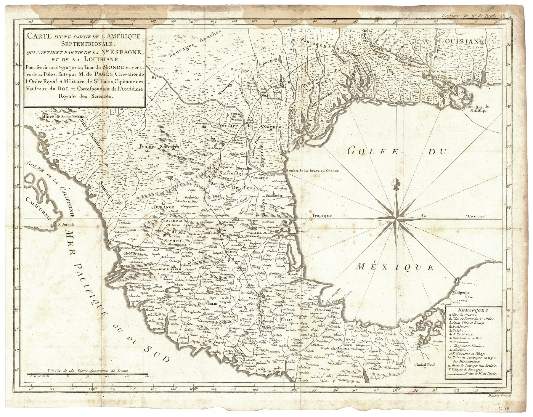
Carte d'une partie de L'Amérique Séptentrionale, qui contient partie de la Nle. Espagne, et de la Louisiane
Pour servir aux Voyages au Tour du Monde et vers les deux Pôles, faits par M. de Pagès, Chevalier de l'Ordre Royal et Militaire de St. Louis, Capitaine des Vaisseaux du Roi, et Correspondant de l'Académie Royale des Sciences
-
Map/Doc
97118
-
Collection
General Map Collection
-
Object Dates
1782 (Creation Date)
-
Subjects
Spanish Texas Mexico
-
Height x Width
14.1 x 18.1 inches
35.8 x 46.0 cm
-
Comments
Map appears in "Voyages Autour du Monde, et vers les deux poles par terre et par mer - Tome Second" (97086)
Related maps
Carte d'une partie de l'Amérique Séptentrionale, qui contient partie de la Nle. Espagne, et de la Louisiane

Print $20.00
- Digital $50.00
Carte d'une partie de l'Amérique Séptentrionale, qui contient partie de la Nle. Espagne, et de la Louisiane
1782
Size 14.1 x 18.5 inches
Map/Doc 94096
Voyages Autour du Monde, et vers les deux poles par terre et par mer - Tome Second

Voyages Autour du Monde, et vers les deux poles par terre et par mer - Tome Second
1782
Map/Doc 97086
Part of: General Map Collection
Hunt County Rolled Sketch 2

Print $20.00
- Digital $50.00
Hunt County Rolled Sketch 2
Size 31.8 x 29.9 inches
Map/Doc 9240
Maps & Lists Showing Prison Lands (Oil & Gas) Leased as of June 1955

Digital $50.00
Maps & Lists Showing Prison Lands (Oil & Gas) Leased as of June 1955
Size 11.4 x 7.2 inches
Map/Doc 62867
Hutchinson County Rolled Sketch 16

Print $20.00
- Digital $50.00
Hutchinson County Rolled Sketch 16
1912
Size 27.5 x 30.2 inches
Map/Doc 6284
Louisiana and Texas Intracoastal Waterway - Matagorda Bay to San Antonio Bay Dredging - Sheet 2

Print $20.00
- Digital $50.00
Louisiana and Texas Intracoastal Waterway - Matagorda Bay to San Antonio Bay Dredging - Sheet 2
1938
Size 31.0 x 41.2 inches
Map/Doc 61815
Pecos County Rolled Sketch 166

Print $22.00
- Digital $50.00
Pecos County Rolled Sketch 166
Size 32.5 x 37.6 inches
Map/Doc 9747
Flight Mission No. DIX-3P, Frame 135, Aransas County

Print $20.00
- Digital $50.00
Flight Mission No. DIX-3P, Frame 135, Aransas County
1956
Size 17.8 x 18.5 inches
Map/Doc 83765
Runnels County Sketch File 11

Print $8.00
Runnels County Sketch File 11
1883
Size 10.7 x 7.9 inches
Map/Doc 35452
Jasper County Working Sketch 30

Print $20.00
- Digital $50.00
Jasper County Working Sketch 30
1956
Size 33.5 x 38.6 inches
Map/Doc 66492
Hardin County Sketch File 60

Print $8.00
- Digital $50.00
Hardin County Sketch File 60
Size 14.4 x 8.9 inches
Map/Doc 25234
Dickens County

Print $20.00
- Digital $50.00
Dickens County
1891
Size 24.5 x 20.2 inches
Map/Doc 4533
Lynn County Working Sketch 4

Print $20.00
- Digital $50.00
Lynn County Working Sketch 4
1965
Size 33.5 x 33.8 inches
Map/Doc 70674
Presidio County Rolled Sketch 99

Print $20.00
- Digital $50.00
Presidio County Rolled Sketch 99
Size 38.7 x 33.6 inches
Map/Doc 9784
You may also like
Callahan County Working Sketch 13

Print $20.00
- Digital $50.00
Callahan County Working Sketch 13
1977
Size 23.8 x 27.6 inches
Map/Doc 67895

[Texas & Pacific Railway through Callahan County]
![64237, [Texas & Pacific Railway through Callahan County], General Map Collection](https://historictexasmaps.com/wmedia_w700/maps/64237.tif.jpg)
Print $20.00
- Digital $50.00
[Texas & Pacific Railway through Callahan County]
1918
Size 21.8 x 9.2 inches
Map/Doc 64237
Chambers County Boundary File 1

Print $28.00
- Digital $50.00
Chambers County Boundary File 1
Size 8.9 x 6.7 inches
Map/Doc 51226
Wise County Working Sketch 29

Print $20.00
- Digital $50.00
Wise County Working Sketch 29
1997
Size 22.3 x 26.8 inches
Map/Doc 72643
Franklin County Sketch File 17

Print $16.00
- Digital $50.00
Franklin County Sketch File 17
1951
Size 11.3 x 8.8 inches
Map/Doc 23026
Kerr County Working Sketch 15

Print $20.00
- Digital $50.00
Kerr County Working Sketch 15
1953
Size 36.2 x 38.6 inches
Map/Doc 70046
Presidio County Working Sketch 28

Print $20.00
- Digital $50.00
Presidio County Working Sketch 28
1945
Size 19.9 x 13.4 inches
Map/Doc 71704
Trinity River, Balltown Sheet/Pilot Grove Creek

Print $20.00
- Digital $50.00
Trinity River, Balltown Sheet/Pilot Grove Creek
1938
Size 40.1 x 33.7 inches
Map/Doc 65196
Pecos County Sketch File 46

Print $26.00
- Digital $50.00
Pecos County Sketch File 46
1921
Size 11.4 x 8.9 inches
Map/Doc 33746
Texas, Matagorda Bay, Matagorda Peninsula, Central Section

Print $20.00
- Digital $50.00
Texas, Matagorda Bay, Matagorda Peninsula, Central Section
1933
Size 28.3 x 42.7 inches
Map/Doc 69987
A Map of Part of Matagorda Peninsula and the Main-land Opposite State of Texas

Print $40.00
- Digital $50.00
A Map of Part of Matagorda Peninsula and the Main-land Opposite State of Texas
1855
Size 32.4 x 62.7 inches
Map/Doc 69979