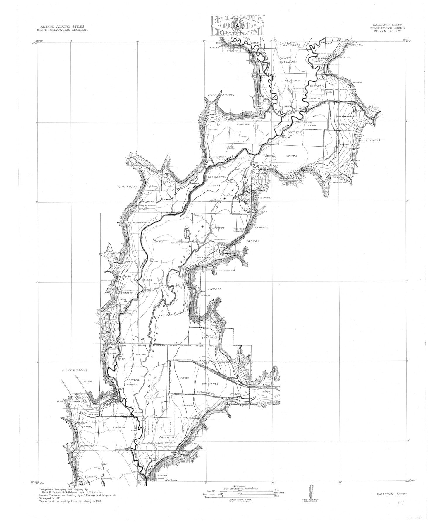
Trinity River, Balltown Sheet/Pilot Grove Creek
-
Map/Doc
65196
-
Collection
General Map Collection
-
Object Dates
1938 (Creation Date)
-
People and Organizations
Texas State Reclamation Department (Publisher)
Eltea Armstrong (Draftsman)
Eltea Armstrong (Compiler)
Dixon B. Penick (Surveyor/Engineer)
B.G. Schenck (Surveyor/Engineer)
J.P. Murray (Surveyor/Engineer)
R.P. Schulke (Surveyor/Engineer)
J.B. Upchurch (Surveyor/Engineer)
-
Counties
Collin
-
Subjects
Cadastral River Surveys Topographic
-
Height x Width
40.1 x 33.7 inches
101.9 x 85.6 cm
-
Comments
Balltown Sheet located north of the Clear Lake Sheet.
Part of: General Map Collection
Willacy County Boundary File 2
![59967, Willacy County Boundary File 2, General Map Collection](https://historictexasmaps.com/wmedia_w700/pdf_converted_jpg/qi_pdf_thumbnail_16950.jpg)
Print $16.00
- Digital $50.00
Willacy County Boundary File 2
Size 11.0 x 8.7 inches
Map/Doc 59967
Zavalla [sic] County
![16938, Zavalla [sic] County, General Map Collection](https://historictexasmaps.com/wmedia_w700/maps/16938.tif.jpg)
Print $20.00
- Digital $50.00
Zavalla [sic] County
1894
Size 42.3 x 44.6 inches
Map/Doc 16938
St. Louis, Brownsville & Mexico Railway Location Map from Mile 0 to Mile 20
![64076, St. Louis, Brownsville & Mexico Railway Location Map from Mile 0 to Mile 20, General Map Collection](https://historictexasmaps.com/wmedia_w700/maps/64076.tif.jpg)
Print $40.00
- Digital $50.00
St. Louis, Brownsville & Mexico Railway Location Map from Mile 0 to Mile 20
1906
Size 19.3 x 57.7 inches
Map/Doc 64076
Map of the Lands Surveyed by the Memphis, El Paso & Pacific R.R. Company
![4850, Map of the Lands Surveyed by the Memphis, El Paso & Pacific R.R. Company, General Map Collection](https://historictexasmaps.com/wmedia_w700/maps/4850.tif.jpg)
Print $20.00
- Digital $50.00
Map of the Lands Surveyed by the Memphis, El Paso & Pacific R.R. Company
1859
Size 11.4 x 18.6 inches
Map/Doc 4850
Travis County Working Sketch 22
![69406, Travis County Working Sketch 22, General Map Collection](https://historictexasmaps.com/wmedia_w700/maps/69406.tif.jpg)
Print $20.00
- Digital $50.00
Travis County Working Sketch 22
Size 19.6 x 20.8 inches
Map/Doc 69406
Medina County Sketch File 16
![31476, Medina County Sketch File 16, General Map Collection](https://historictexasmaps.com/wmedia_w700/pdf_converted_jpg/qi_pdf_thumbnail_13054.jpg)
Print $8.00
- Digital $50.00
Medina County Sketch File 16
1948
Size 11.4 x 8.8 inches
Map/Doc 31476
Brewster County Rolled Sketch K
![5321, Brewster County Rolled Sketch K, General Map Collection](https://historictexasmaps.com/wmedia_w700/maps/5321.tif.jpg)
Print $20.00
- Digital $50.00
Brewster County Rolled Sketch K
1884
Size 19.6 x 13.9 inches
Map/Doc 5321
Dallas County Sketch File 21
![20443, Dallas County Sketch File 21, General Map Collection](https://historictexasmaps.com/wmedia_w700/pdf_converted_jpg/qi_pdf_thumbnail_10621.jpg)
Print $22.00
- Digital $50.00
Dallas County Sketch File 21
1888
Size 14.2 x 8.9 inches
Map/Doc 20443
Nacogdoches County Rolled Sketch 1
![6836, Nacogdoches County Rolled Sketch 1, General Map Collection](https://historictexasmaps.com/wmedia_w700/maps/6836.tif.jpg)
Print $20.00
- Digital $50.00
Nacogdoches County Rolled Sketch 1
1950
Size 33.5 x 31.0 inches
Map/Doc 6836
Southern Cattle Fever
![95143, Southern Cattle Fever, General Map Collection](https://historictexasmaps.com/wmedia_w700/maps/95143.tif.jpg)
Print $20.00
- Digital $50.00
Southern Cattle Fever
Size 9.2 x 13.7 inches
Map/Doc 95143
Flight Mission No. BRE-5P, Frame 191, Nueces County
![86837, Flight Mission No. BRE-5P, Frame 191, Nueces County, General Map Collection](https://historictexasmaps.com/wmedia_w700/pdf_converted_jpg/qi_pdf_thumbnail_33974.jpg)
Print $20.00
- Digital $50.00
Flight Mission No. BRE-5P, Frame 191, Nueces County
1956
Size 18.7 x 22.5 inches
Map/Doc 86837
Flight Mission No. BRA-16M, Frame 174, Jefferson County
![85772, Flight Mission No. BRA-16M, Frame 174, Jefferson County, General Map Collection](https://historictexasmaps.com/wmedia_w700/pdf_converted_jpg/qi_pdf_thumbnail_32969.jpg)
Print $20.00
- Digital $50.00
Flight Mission No. BRA-16M, Frame 174, Jefferson County
1953
Size 18.6 x 22.4 inches
Map/Doc 85772
You may also like
Orange County Working Sketch 29
![71361, Orange County Working Sketch 29, General Map Collection](https://historictexasmaps.com/wmedia_w700/maps/71361.tif.jpg)
Print $40.00
- Digital $50.00
Orange County Working Sketch 29
Size 32.9 x 50.0 inches
Map/Doc 71361
Map of South America engraved to illustrate Mitchell's school and family geography
![93501, Map of South America engraved to illustrate Mitchell's school and family geography, General Map Collection](https://historictexasmaps.com/wmedia_w700/maps/93501.tif.jpg)
Print $20.00
- Digital $50.00
Map of South America engraved to illustrate Mitchell's school and family geography
1839
Size 11.8 x 9.5 inches
Map/Doc 93501
Flight Mission No. BQR-12K, Frame 48, Brazoria County
![84063, Flight Mission No. BQR-12K, Frame 48, Brazoria County, General Map Collection](https://historictexasmaps.com/wmedia_w700/pdf_converted_jpg/qi_pdf_thumbnail_31281.jpg)
Print $20.00
- Digital $50.00
Flight Mission No. BQR-12K, Frame 48, Brazoria County
1952
Size 19.0 x 22.7 inches
Map/Doc 84063
General Highway Map, Jack County, Texas
![79139, General Highway Map, Jack County, Texas, Texas State Library and Archives](https://historictexasmaps.com/wmedia_w700/maps/79139.tif.jpg)
Print $20.00
General Highway Map, Jack County, Texas
1940
Size 18.4 x 24.8 inches
Map/Doc 79139
Flight Mission No. CRK-3P, Frame 128, Refugio County
![86916, Flight Mission No. CRK-3P, Frame 128, Refugio County, General Map Collection](https://historictexasmaps.com/wmedia_w700/pdf_converted_jpg/qi_pdf_thumbnail_34050.jpg)
Print $20.00
- Digital $50.00
Flight Mission No. CRK-3P, Frame 128, Refugio County
1956
Size 18.6 x 22.4 inches
Map/Doc 86916
[Sketch showing positions of surveys bordering on South boundary line of Archer County and North boundary line of Young County
![90174, [Sketch showing positions of surveys bordering on South boundary line of Archer County and North boundary line of Young County, Twichell Survey Records](https://historictexasmaps.com/wmedia_w700/maps/90174-1.tif.jpg)
Print $20.00
- Digital $50.00
[Sketch showing positions of surveys bordering on South boundary line of Archer County and North boundary line of Young County
1894
Size 14.0 x 36.8 inches
Map/Doc 90174
Maps of Gulf Intracoastal Waterway, Texas - Sabine River to the Rio Grande and connecting waterways including ship channels
![61991, Maps of Gulf Intracoastal Waterway, Texas - Sabine River to the Rio Grande and connecting waterways including ship channels, General Map Collection](https://historictexasmaps.com/wmedia_w700/maps/61991.tif.jpg)
Print $20.00
- Digital $50.00
Maps of Gulf Intracoastal Waterway, Texas - Sabine River to the Rio Grande and connecting waterways including ship channels
1966
Size 14.6 x 20.5 inches
Map/Doc 61991
San Augustine County Working Sketch 24
![63712, San Augustine County Working Sketch 24, General Map Collection](https://historictexasmaps.com/wmedia_w700/maps/63712.tif.jpg)
Print $20.00
- Digital $50.00
San Augustine County Working Sketch 24
Size 27.8 x 39.1 inches
Map/Doc 63712
Flight Mission No. CLL-1N, Frame 81, Willacy County
![87027, Flight Mission No. CLL-1N, Frame 81, Willacy County, General Map Collection](https://historictexasmaps.com/wmedia_w700/pdf_converted_jpg/qi_pdf_thumbnail_34161.jpg)
Print $20.00
- Digital $50.00
Flight Mission No. CLL-1N, Frame 81, Willacy County
1954
Size 18.3 x 22.1 inches
Map/Doc 87027
Map of the United States and Canada designed to accompany Smith's Geography for Schools
![93884, Map of the United States and Canada designed to accompany Smith's Geography for Schools, Holcomb Digital Map Collection](https://historictexasmaps.com/wmedia_w700/maps/93884.tif.jpg)
Print $20.00
- Digital $50.00
Map of the United States and Canada designed to accompany Smith's Geography for Schools
1850
Size 12.1 x 19.2 inches
Map/Doc 93884
Newton County Working Sketch 8
![71254, Newton County Working Sketch 8, General Map Collection](https://historictexasmaps.com/wmedia_w700/maps/71254.tif.jpg)
Print $20.00
- Digital $50.00
Newton County Working Sketch 8
Size 23.2 x 18.5 inches
Map/Doc 71254
Terrell County Rolled Sketch 60
![7976, Terrell County Rolled Sketch 60, General Map Collection](https://historictexasmaps.com/wmedia_w700/maps/7976.tif.jpg)
Print $20.00
- Digital $50.00
Terrell County Rolled Sketch 60
1998
Size 13.2 x 38.1 inches
Map/Doc 7976