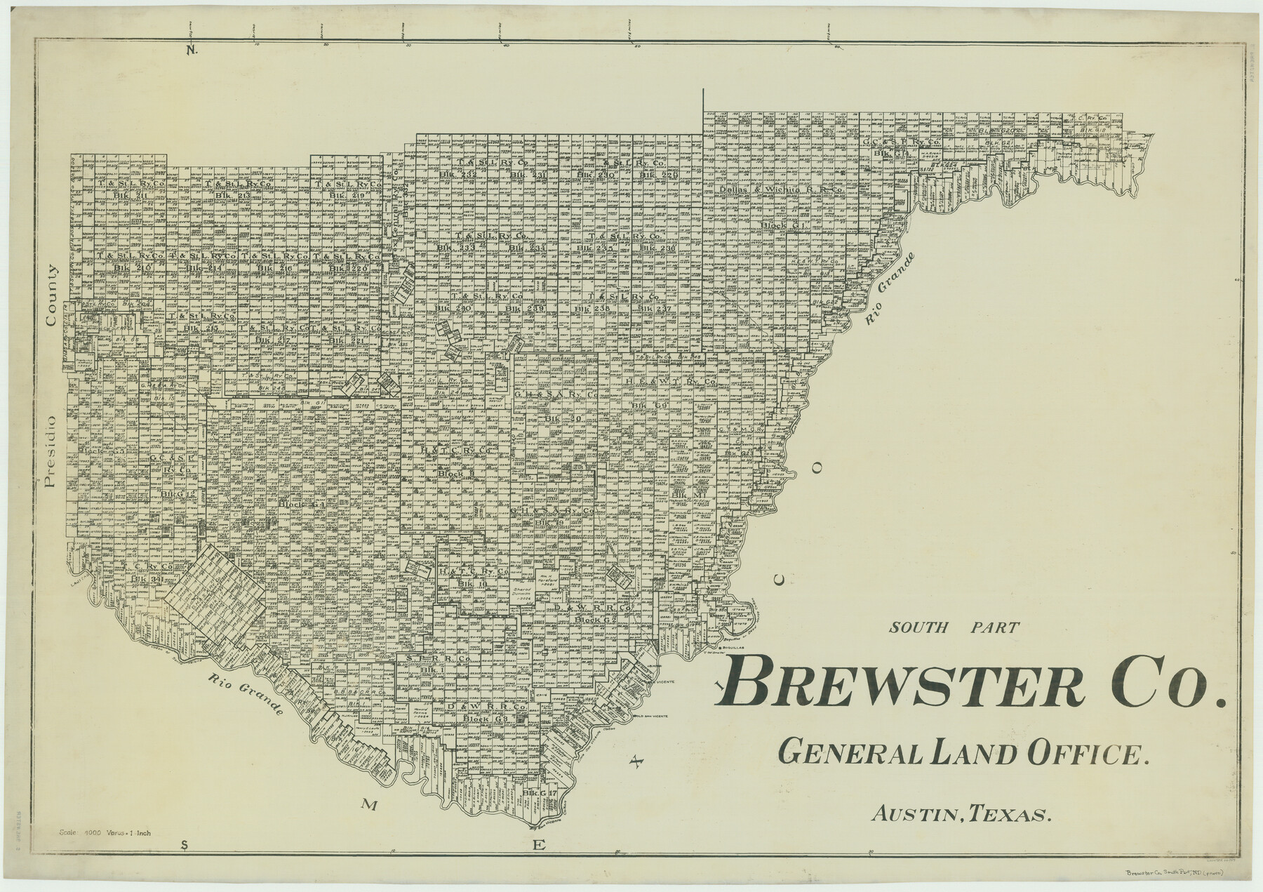
South Part Brewster Co.
-
Map/Doc
66724
-
Collection
General Map Collection
-
People and Organizations
Texas General Land Office (Publisher)
-
Counties
Brewster
-
Subjects
County
-
Height x Width
35.2 x 49.8 inches
89.4 x 126.5 cm
Part of: General Map Collection
Zapata County Working Sketch 24

Print $20.00
- Digital $50.00
Zapata County Working Sketch 24
1992
Size 28.2 x 23.9 inches
Map/Doc 62075
Presidio County Working Sketch 116

Print $20.00
- Digital $50.00
Presidio County Working Sketch 116
1982
Size 27.8 x 42.4 inches
Map/Doc 71793
Upshur County Working Sketch 7

Print $40.00
- Digital $50.00
Upshur County Working Sketch 7
1953
Size 49.0 x 43.1 inches
Map/Doc 69563
Sterling County Working Sketch 6

Print $40.00
- Digital $50.00
Sterling County Working Sketch 6
1955
Size 38.1 x 121.6 inches
Map/Doc 63988
Wise County Sketch File 7

Print $4.00
- Digital $50.00
Wise County Sketch File 7
1857
Size 8.1 x 14.0 inches
Map/Doc 40535
Sherman County Boundary File 4

Print $54.00
- Digital $50.00
Sherman County Boundary File 4
Size 8.9 x 8.5 inches
Map/Doc 58782
Cass County Working Sketch 35

Print $20.00
- Digital $50.00
Cass County Working Sketch 35
1982
Size 23.5 x 44.8 inches
Map/Doc 67938
Clay County Working Sketch 2

Print $20.00
- Digital $50.00
Clay County Working Sketch 2
1907
Size 26.5 x 16.2 inches
Map/Doc 68025
Presidio County Rolled Sketch 53

Print $20.00
- Digital $50.00
Presidio County Rolled Sketch 53
1911
Size 13.0 x 22.2 inches
Map/Doc 7346
Menard County Working Sketch Graphic Index

Print $20.00
- Digital $50.00
Menard County Working Sketch Graphic Index
1942
Size 38.4 x 41.7 inches
Map/Doc 76640
[Sketch for Mineral Application 26501 - Sabine River, T. A. Oldhausen]
![2834, [Sketch for Mineral Application 26501 - Sabine River, T. A. Oldhausen], General Map Collection](https://historictexasmaps.com/wmedia_w700/maps/2834.tif.jpg)
Print $20.00
- Digital $50.00
[Sketch for Mineral Application 26501 - Sabine River, T. A. Oldhausen]
1931
Size 23.9 x 36.0 inches
Map/Doc 2834

You may also like
Calhoun County Rolled Sketch 34

Print $181.00
- Digital $50.00
Calhoun County Rolled Sketch 34
1977
Size 10.0 x 16.2 inches
Map/Doc 43714
[Gunter & Munson, Maddox Bros. & Anderson Blocks F and A and blocks south]
![91850, [Gunter & Munson, Maddox Bros. & Anderson Blocks F and A and blocks south], Twichell Survey Records](https://historictexasmaps.com/wmedia_w700/maps/91850-1.tif.jpg)
Print $20.00
- Digital $50.00
[Gunter & Munson, Maddox Bros. & Anderson Blocks F and A and blocks south]
Size 18.3 x 19.8 inches
Map/Doc 91850
Smith County Rolled Sketch 6

Print $20.00
- Digital $50.00
Smith County Rolled Sketch 6
1999
Size 43.3 x 30.0 inches
Map/Doc 10699
General Highway Map, Sabine County, Texas

Print $20.00
General Highway Map, Sabine County, Texas
1961
Size 24.6 x 18.1 inches
Map/Doc 79644
Galveston County NRC Article 33.136 Sketch 44

Print $22.00
- Digital $50.00
Galveston County NRC Article 33.136 Sketch 44
2007
Size 36.6 x 24.6 inches
Map/Doc 88352
Fractional Township No. 9 South Range No. 9 East of the Indian Meridian, Indian Territory

Print $20.00
- Digital $50.00
Fractional Township No. 9 South Range No. 9 East of the Indian Meridian, Indian Territory
1898
Size 19.2 x 24.4 inches
Map/Doc 75216
Current Miscellaneous File 82

Print $4.00
- Digital $50.00
Current Miscellaneous File 82
Size 12.0 x 8.8 inches
Map/Doc 74224
In the Supreme Court of the United States The State of Oklahoma, Complainant vs. The State of Texas, Defendant, The United States of America, Intervener - 1921

Print $20.00
- Digital $50.00
In the Supreme Court of the United States The State of Oklahoma, Complainant vs. The State of Texas, Defendant, The United States of America, Intervener - 1921
1921
Size 24.4 x 32.4 inches
Map/Doc 75128
Denton County Working Sketch 22

Print $20.00
- Digital $50.00
Denton County Working Sketch 22
1983
Size 36.1 x 34.0 inches
Map/Doc 68627
Floyd County Rolled Sketch 8

Print $20.00
- Digital $50.00
Floyd County Rolled Sketch 8
1947
Size 29.6 x 19.9 inches
Map/Doc 5882
Flight Mission No. CRC-2R, Frame 183, Chambers County

Print $20.00
- Digital $50.00
Flight Mission No. CRC-2R, Frame 183, Chambers County
1956
Size 18.7 x 22.3 inches
Map/Doc 84761
Polk County Working Sketch 13

Print $20.00
- Digital $50.00
Polk County Working Sketch 13
1942
Size 17.1 x 20.6 inches
Map/Doc 71628