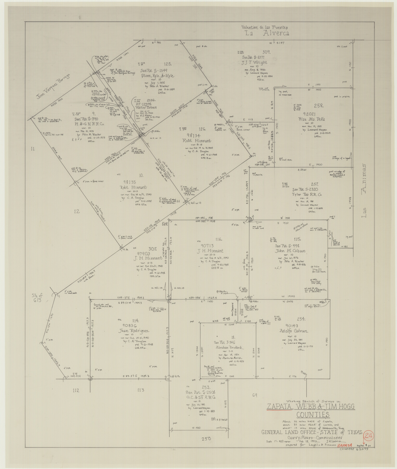
Zapata County Working Sketch 24
-
Map/Doc
62075
-
Collection
General Map Collection
-
Object Dates
2/18/1992 (Creation Date)
-
People and Organizations
Joan Kilpatrick (Draftsman)
-
Counties
Zapata Webb Jim Hogg
-
Subjects
Surveying Working Sketch
-
Height x Width
28.2 x 23.9 inches
71.6 x 60.7 cm
-
Scale
1" = 400 varas
Part of: General Map Collection
Burleson County Sketch File 7

Print $40.00
- Digital $50.00
Burleson County Sketch File 7
1935
Size 17.0 x 14.5 inches
Map/Doc 16653
Hamilton County Working Sketch 15

Print $40.00
- Digital $50.00
Hamilton County Working Sketch 15
1949
Size 54.5 x 37.6 inches
Map/Doc 63353
Red River, Bois D'Arc Creek Floodway Sheet No. 8

Print $20.00
- Digital $50.00
Red River, Bois D'Arc Creek Floodway Sheet No. 8
1928
Size 17.6 x 24.8 inches
Map/Doc 65272
Hall County Working Sketch 4

Print $20.00
- Digital $50.00
Hall County Working Sketch 4
1923
Size 29.0 x 19.7 inches
Map/Doc 63332
Pecos County Sketch File 118

Print $28.00
- Digital $50.00
Pecos County Sketch File 118
1933
Size 5.0 x 7.5 inches
Map/Doc 34097
Houston County Sketch File 41

Print $6.00
- Digital $50.00
Houston County Sketch File 41
1845
Size 16.0 x 10.2 inches
Map/Doc 26828
Childress County Sketch File 7a

Print $20.00
- Digital $50.00
Childress County Sketch File 7a
Size 14.9 x 17.7 inches
Map/Doc 11080
Val Verde County Working Sketch 63

Print $20.00
- Digital $50.00
Val Verde County Working Sketch 63
1959
Size 23.2 x 32.1 inches
Map/Doc 72198
Bee County Working Sketch 31

Print $20.00
- Digital $50.00
Bee County Working Sketch 31
1929
Size 13.5 x 25.1 inches
Map/Doc 67282
Orange County Rolled Sketch 23

Print $20.00
- Digital $50.00
Orange County Rolled Sketch 23
1950
Size 29.0 x 35.3 inches
Map/Doc 7185
Bailey County Sketch File 19

Print $8.00
- Digital $50.00
Bailey County Sketch File 19
1882
Size 13.2 x 8.4 inches
Map/Doc 13987
Flight Mission No. CLL-1N, Frame 35, Willacy County

Print $20.00
- Digital $50.00
Flight Mission No. CLL-1N, Frame 35, Willacy County
1954
Size 18.5 x 22.1 inches
Map/Doc 87016
You may also like
Sutton County Sketch File F

Print $18.00
- Digital $50.00
Sutton County Sketch File F
1906
Size 14.1 x 8.7 inches
Map/Doc 37391
Map of DeWitt County

Print $20.00
- Digital $50.00
Map of DeWitt County
1881
Size 21.7 x 24.3 inches
Map/Doc 3478
Sketch showing recent surveys of State School Land adjoining Capitol Leagues No. 357 1/2, 367, 373 and 374 corrected out of conflict

Print $2.00
- Digital $50.00
Sketch showing recent surveys of State School Land adjoining Capitol Leagues No. 357 1/2, 367, 373 and 374 corrected out of conflict
1905
Size 7.4 x 10.5 inches
Map/Doc 90533
Revised Sectional Map No. 3 showing land surveys in counties of Loving, Reeves and Culberson and portions of Winkler, Ward, Pecos and Jeff Davis, Texas

Print $20.00
- Digital $50.00
Revised Sectional Map No. 3 showing land surveys in counties of Loving, Reeves and Culberson and portions of Winkler, Ward, Pecos and Jeff Davis, Texas
Size 19.0 x 24.7 inches
Map/Doc 4478
Flight Mission No. DIX-10P, Frame 172, Aransas County

Print $20.00
- Digital $50.00
Flight Mission No. DIX-10P, Frame 172, Aransas County
1956
Size 18.8 x 22.3 inches
Map/Doc 83962
[Sketch showing Block H, Section 11 of Roberts County, including the south bank of the Canadian River]
![91761, [Sketch showing Block H, Section 11 of Roberts County, including the south bank of the Canadian River], Twichell Survey Records](https://historictexasmaps.com/wmedia_w700/maps/91761-1.tif.jpg)
Print $2.00
- Digital $50.00
[Sketch showing Block H, Section 11 of Roberts County, including the south bank of the Canadian River]
1919
Size 14.4 x 8.8 inches
Map/Doc 91761
Nueces County Sketch File 12b

Print $8.00
- Digital $50.00
Nueces County Sketch File 12b
1889
Size 14.2 x 8.8 inches
Map/Doc 32530
Panola County Working Sketch 3

Print $20.00
- Digital $50.00
Panola County Working Sketch 3
1935
Map/Doc 71412
Jefferson County Working Sketch 24

Print $20.00
- Digital $50.00
Jefferson County Working Sketch 24
1977
Size 28.4 x 44.5 inches
Map/Doc 66567
[T. & P. Block 36, Townships 1N - 5N]
![93132, [T. & P. Block 36, Townships 1N - 5N], Twichell Survey Records](https://historictexasmaps.com/wmedia_w700/maps/93132-1.tif.jpg)
Print $40.00
- Digital $50.00
[T. & P. Block 36, Townships 1N - 5N]
Size 21.3 x 87.8 inches
Map/Doc 93132
Glasscock County Sketch File 17

Print $44.00
- Digital $50.00
Glasscock County Sketch File 17
1936
Size 11.4 x 8.8 inches
Map/Doc 24188
Map of University Land in Shackelford and Callahan Counties

Print $20.00
- Digital $50.00
Map of University Land in Shackelford and Callahan Counties
1905
Size 33.4 x 25.3 inches
Map/Doc 2435