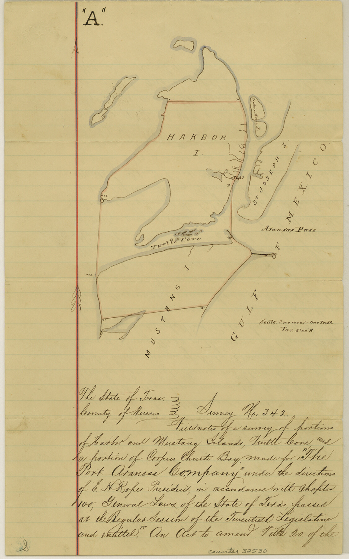
Nueces County Sketch File 12b
[Field notes and sketch of a survey of portions of Aransas Harbor, Mustang Island, Turtle Cove and a portion of Corpus Christi Bay]
-
Map/Doc
32530
-
Collection
General Map Collection
-
Object Dates
4/6/1889 (Creation Date)
4/18/1889 (File Date)
4/6/1889 (Survey Date)
4/11/1889 (Creation Date)
-
People and Organizations
C.F.H. Blucher (Surveyor/Engineer)
C.F.H. Blucher (Chainman/Field Personnel)
Crispin Gaceres (Chainman/Field Personnel)
-
Counties
Nueces Aransas
-
Subjects
Surveying Sketch File
-
Height x Width
14.2 x 8.8 inches
36.1 x 22.4 cm
-
Medium
paper, manuscript
-
Scale
1" = 2000 varas
-
Features
Harbor Island
Lydia Ann Island
St. Joseph Island
Turtle Cove
Gulf of Mexico
Mustang Island
Corpus Christi Bay
Corpus Christi
Aransas Pass Lighthouse
Aransas Harbor
Part of: General Map Collection
Map of McMullen County

Print $20.00
- Digital $50.00
Map of McMullen County
1887
Size 26.8 x 18.6 inches
Map/Doc 3866
Travis County

Print $40.00
- Digital $50.00
Travis County
1880
Size 59.0 x 70.2 inches
Map/Doc 16902
St. Louis, Brownsville & Mexico Railway Location Map from Mile 40 to Mile 60

Print $40.00
- Digital $50.00
St. Louis, Brownsville & Mexico Railway Location Map from Mile 40 to Mile 60
1905
Size 20.3 x 136.1 inches
Map/Doc 89282
Hardeman County Rolled Sketch 14

Print $20.00
- Digital $50.00
Hardeman County Rolled Sketch 14
1884
Size 18.2 x 29.1 inches
Map/Doc 6071
Baylor County Sketch File 12B

Print $6.00
- Digital $50.00
Baylor County Sketch File 12B
1900
Size 13.4 x 9.0 inches
Map/Doc 14152
Zavala County Working Sketch 20

Print $20.00
- Digital $50.00
Zavala County Working Sketch 20
1977
Size 40.0 x 34.5 inches
Map/Doc 62095
Brazos River, Brazos River Sheet 1

Print $20.00
- Digital $50.00
Brazos River, Brazos River Sheet 1
1926
Size 20.7 x 25.3 inches
Map/Doc 69665
Sutton County Sketch File 1

Print $6.00
- Digital $50.00
Sutton County Sketch File 1
1885
Size 14.3 x 8.9 inches
Map/Doc 37348
Winkler County Working Sketch 3

Print $40.00
- Digital $50.00
Winkler County Working Sketch 3
1944
Size 43.5 x 60.5 inches
Map/Doc 72597
Industrial Site, Imperial State Prison Farm, Sugarland, Texas

Print $20.00
- Digital $50.00
Industrial Site, Imperial State Prison Farm, Sugarland, Texas
Size 26.6 x 27.5 inches
Map/Doc 73562
Map of San Patricio County

Print $20.00
- Digital $50.00
Map of San Patricio County
1863
Size 17.9 x 26.3 inches
Map/Doc 4018
Comanche County Sketch File 10

Print $4.00
- Digital $50.00
Comanche County Sketch File 10
1859
Size 8.4 x 16.0 inches
Map/Doc 19070
You may also like
Donley County Boundary File 5

Print $4.00
- Digital $50.00
Donley County Boundary File 5
Size 11.2 x 8.8 inches
Map/Doc 52635
Property Line Map, Public Housing Authority

Print $3.00
- Digital $50.00
Property Line Map, Public Housing Authority
Size 11.9 x 15.5 inches
Map/Doc 92707
Rusk County Working Sketch 22

Print $20.00
- Digital $50.00
Rusk County Working Sketch 22
1950
Size 22.5 x 12.8 inches
Map/Doc 63658
Polk County Working Sketch 6

Print $20.00
- Digital $50.00
Polk County Working Sketch 6
1933
Size 22.8 x 32.7 inches
Map/Doc 71621
Real County Working Sketch 74

Print $20.00
- Digital $50.00
Real County Working Sketch 74
1979
Size 17.1 x 23.5 inches
Map/Doc 71966
[Right of Way & Track Map, The Texas & Pacific Ry. Co. Main Line]
![64668, [Right of Way & Track Map, The Texas & Pacific Ry. Co. Main Line], General Map Collection](https://historictexasmaps.com/wmedia_w700/maps/64668.tif.jpg)
Print $20.00
- Digital $50.00
[Right of Way & Track Map, The Texas & Pacific Ry. Co. Main Line]
Size 11.0 x 18.4 inches
Map/Doc 64668
Wilbarger County Sketch File 21

Print $4.00
- Digital $50.00
Wilbarger County Sketch File 21
1889
Size 11.1 x 8.6 inches
Map/Doc 40219
[Large surveys along the Navasota River]
![48, [Large surveys along the Navasota River], General Map Collection](https://historictexasmaps.com/wmedia_w700/maps/48.tif.jpg)
Print $20.00
- Digital $50.00
[Large surveys along the Navasota River]
1840
Size 24.5 x 14.3 inches
Map/Doc 48
Connected Map of the County of Victoria

Print $40.00
- Digital $50.00
Connected Map of the County of Victoria
1838
Size 79.7 x 49.0 inches
Map/Doc 1946
Mapa del Presidio de San Antonio de Bexar, i sus Misiones de la Provinsia de Texas

Print $20.00
Mapa del Presidio de San Antonio de Bexar, i sus Misiones de la Provinsia de Texas
1764
Size 14.5 x 18.4 inches
Map/Doc 94455
Kimble County Working Sketch 9

Print $20.00
- Digital $50.00
Kimble County Working Sketch 9
1920
Size 14.3 x 17.3 inches
Map/Doc 70077
Irion County Working Sketch 5

Print $20.00
- Digital $50.00
Irion County Working Sketch 5
1929
Size 24.3 x 17.9 inches
Map/Doc 66414