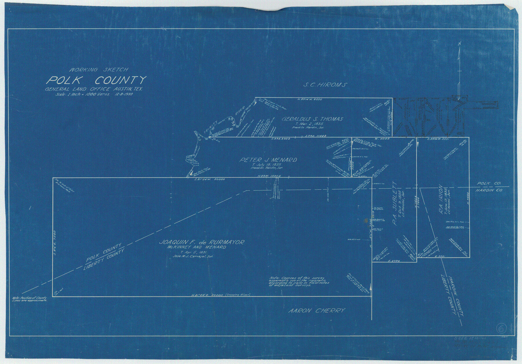
Polk County Working Sketch 6
-
Map/Doc
71621
-
Collection
General Map Collection
-
Object Dates
12/8/1933 (Creation Date)
-
Counties
Polk Liberty Hardin
-
Subjects
Surveying Working Sketch
-
Height x Width
22.8 x 32.7 inches
57.9 x 83.1 cm
-
Scale
1" = 1000 varas
Part of: General Map Collection

Reagan County Working Sketch 4

Print $20.00
- Digital $50.00
Reagan County Working Sketch 4
1923
Size 16.8 x 26.3 inches
Map/Doc 71844
Terrell County Working Sketch 22a

Print $20.00
- Digital $50.00
Terrell County Working Sketch 22a
1939
Size 39.8 x 40.9 inches
Map/Doc 71493
Kendall County Rolled Sketch 6

Print $20.00
- Digital $50.00
Kendall County Rolled Sketch 6
Size 29.6 x 39.4 inches
Map/Doc 6459
Hall County Sketch File 11

Print $12.00
- Digital $50.00
Hall County Sketch File 11
1884
Size 12.8 x 8.3 inches
Map/Doc 24808
Jackson County Sketch File 12

Print $20.00
- Digital $50.00
Jackson County Sketch File 12
1907
Size 12.3 x 20.7 inches
Map/Doc 11838
Flight Mission No. DQN-6K, Frame 90, Calhoun County

Print $20.00
- Digital $50.00
Flight Mission No. DQN-6K, Frame 90, Calhoun County
1953
Size 18.6 x 22.2 inches
Map/Doc 84450
Brewster County Rolled Sketch 73

Print $20.00
- Digital $50.00
Brewster County Rolled Sketch 73
1938
Size 19.7 x 23.3 inches
Map/Doc 5239
Chart of the West Indies and Spanish Dominions in North America

Print $20.00
- Digital $50.00
Chart of the West Indies and Spanish Dominions in North America
1803
Size 25.3 x 38.4 inches
Map/Doc 97136
Map of Maverick County

Print $20.00
- Digital $50.00
Map of Maverick County
1875
Size 36.3 x 23.7 inches
Map/Doc 3849
Calhoun County Boundary File 14

Print $58.00
- Digital $50.00
Calhoun County Boundary File 14
Size 11.2 x 8.8 inches
Map/Doc 51014
Runnels County Sketch File 38

Print $20.00
Runnels County Sketch File 38
1891
Size 17.6 x 24.9 inches
Map/Doc 12269
You may also like

Brewster County Rolled Sketch 114

Print $20.00
- Digital $50.00
Brewster County Rolled Sketch 114
1964
Size 11.6 x 18.5 inches
Map/Doc 5275
Nueces County Rolled Sketch 29

Print $20.00
- Digital $50.00
Nueces County Rolled Sketch 29
1951
Size 25.0 x 22.7 inches
Map/Doc 6875
Edwards County Working Sketch 78

Print $20.00
- Digital $50.00
Edwards County Working Sketch 78
1962
Size 26.5 x 22.1 inches
Map/Doc 68954
Map of Chicago, Rock Island & Texas Railway through Wise and Tarrant County, Texas

Print $40.00
- Digital $50.00
Map of Chicago, Rock Island & Texas Railway through Wise and Tarrant County, Texas
1893
Size 19.4 x 121.0 inches
Map/Doc 64428
Flight Mission No. CRE-2R, Frame 170, Jackson County

Print $20.00
- Digital $50.00
Flight Mission No. CRE-2R, Frame 170, Jackson County
1956
Size 18.6 x 22.1 inches
Map/Doc 85380
Rains County Working Sketch 8

Print $20.00
- Digital $50.00
Rains County Working Sketch 8
1965
Size 24.3 x 28.1 inches
Map/Doc 71834
Flight Mission No. CRE-2R, Frame 166, Jackson County

Print $20.00
- Digital $50.00
Flight Mission No. CRE-2R, Frame 166, Jackson County
1956
Size 18.5 x 22.2 inches
Map/Doc 85376

Brewster County Working Sketch 38

Print $20.00
- Digital $50.00
Brewster County Working Sketch 38
1944
Size 36.3 x 28.4 inches
Map/Doc 67572
Pecos County Working Sketch 32

Print $20.00
- Digital $50.00
Pecos County Working Sketch 32
1936
Size 21.8 x 22.2 inches
Map/Doc 71504
[Plat showing connecting lines for the purpose of locating 4.3 acres in Caldwell County]
![90221, [Plat showing connecting lines for the purpose of locating 4.3 acres in Caldwell County], Twichell Survey Records](https://historictexasmaps.com/wmedia_w700/maps/90221-1.tif.jpg)
Print $2.00
- Digital $50.00
[Plat showing connecting lines for the purpose of locating 4.3 acres in Caldwell County]
1923
Size 7.0 x 10.0 inches
Map/Doc 90221