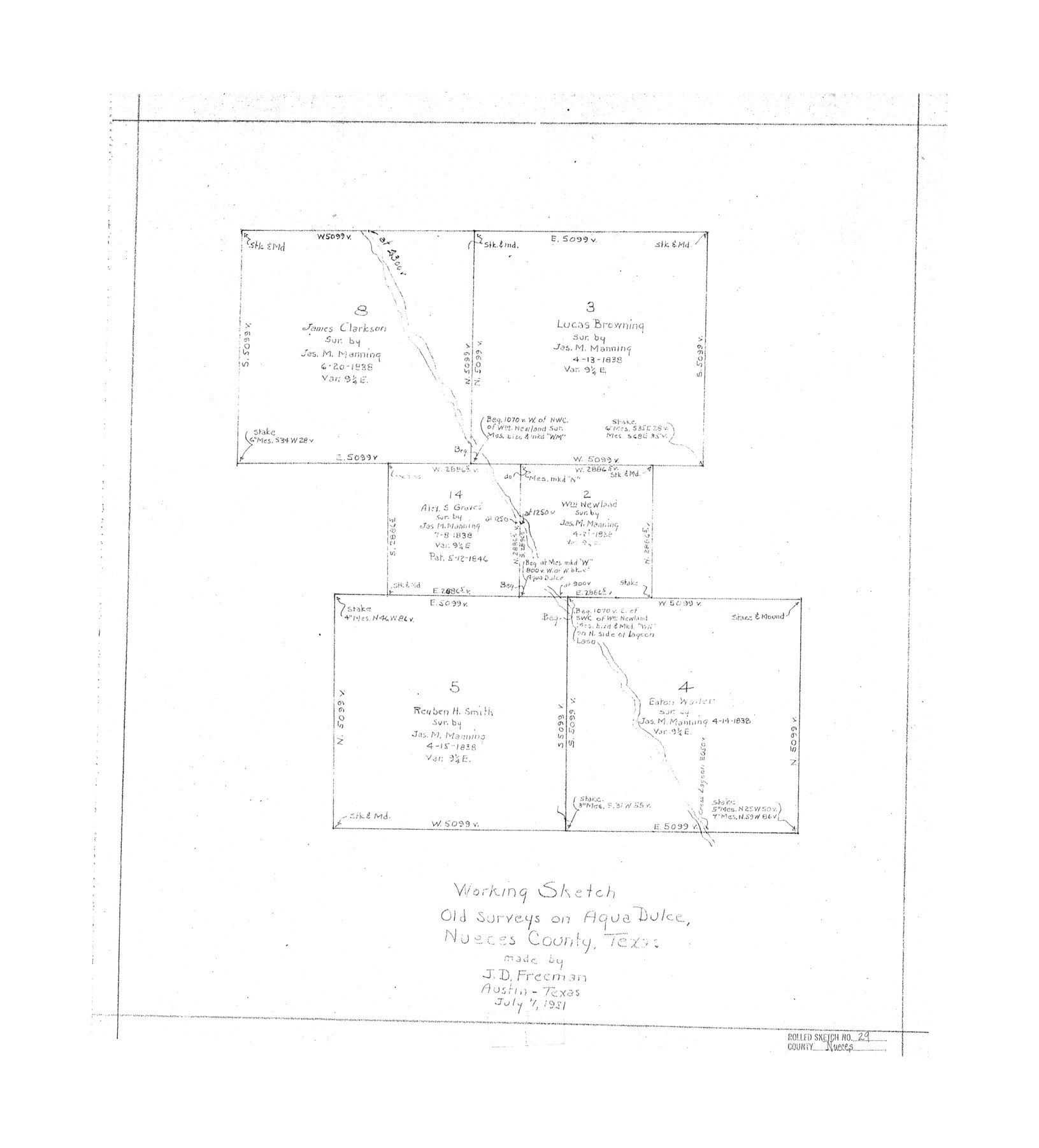
Nueces County Rolled Sketch 29
Working Sketch, old surveys on Agua Dulce, Nueces County, Texas
-
Map/Doc
6875
-
Collection
General Map Collection
-
Object Dates
1951/7/7 (Creation Date)
-
People and Organizations
J.D. Freeman (Surveyor/Engineer)
-
Counties
Nueces
-
Subjects
Surveying Rolled Sketch
-
Height x Width
25.0 x 22.7 inches
63.5 x 57.7 cm
Part of: General Map Collection
Robertson County Sketch File 9

Print $68.00
Robertson County Sketch File 9
1846
Size 10.2 x 8.3 inches
Map/Doc 35366
[Sketch for Mineral Application 16777]
![65655, [Sketch for Mineral Application 16777], General Map Collection](https://historictexasmaps.com/wmedia_w700/maps/65655-1.tif.jpg)
Print $40.00
- Digital $50.00
[Sketch for Mineral Application 16777]
Size 19.8 x 80.3 inches
Map/Doc 65655
Colorado County Sketch File 27

Print $20.00
- Digital $50.00
Colorado County Sketch File 27
1911
Size 25.3 x 19.4 inches
Map/Doc 11138
Current Miscellaneous File 16

Print $20.00
- Digital $50.00
Current Miscellaneous File 16
1951
Size 10.7 x 8.2 inches
Map/Doc 73830
Cherokee County Sketch File 12

Print $4.00
- Digital $50.00
Cherokee County Sketch File 12
1860
Size 6.7 x 8.3 inches
Map/Doc 18140
Lampasas County Sketch File 20

Print $4.00
- Digital $50.00
Lampasas County Sketch File 20
Size 7.4 x 8.7 inches
Map/Doc 29434
Rusk County Working Sketch 24

Print $20.00
- Digital $50.00
Rusk County Working Sketch 24
1949
Size 20.2 x 24.7 inches
Map/Doc 63660
Starr County Sketch File 30B

Print $12.00
- Digital $50.00
Starr County Sketch File 30B
1935
Size 9.3 x 9.1 inches
Map/Doc 36954
Burleson County Working Sketch 1

Print $20.00
- Digital $50.00
Burleson County Working Sketch 1
1928
Size 23.4 x 17.4 inches
Map/Doc 67720
Galveston County Sketch File 24

Print $20.00
- Digital $50.00
Galveston County Sketch File 24
Size 15.8 x 18.1 inches
Map/Doc 11531
Flight Mission No. BRE-1P, Frame 67, Nueces County

Print $20.00
- Digital $50.00
Flight Mission No. BRE-1P, Frame 67, Nueces County
1956
Size 18.7 x 22.4 inches
Map/Doc 86649
Brewster County Working Sketch 98

Print $20.00
- Digital $50.00
Brewster County Working Sketch 98
1978
Size 44.9 x 28.5 inches
Map/Doc 67698
You may also like
Caldwell County Working Sketch Graphic Index

Print $20.00
- Digital $50.00
Caldwell County Working Sketch Graphic Index
1935
Size 36.7 x 41.3 inches
Map/Doc 76483

Sketch of a reconnaissance of Aransas and Corpus Christi Bays

Print $20.00
- Digital $50.00
Sketch of a reconnaissance of Aransas and Corpus Christi Bays
1855
Size 25.7 x 18.3 inches
Map/Doc 72969
Harris County Sketch File A

Print $4.00
- Digital $50.00
Harris County Sketch File A
1898
Size 12.8 x 8.5 inches
Map/Doc 25306
Map of Ochiltree County, Texas

Print $20.00
- Digital $50.00
Map of Ochiltree County, Texas
Size 17.9 x 14.6 inches
Map/Doc 4610
[Sketch for Mineral Application 26501 - Sabine River, T. A. Oldhausen]
![2834, [Sketch for Mineral Application 26501 - Sabine River, T. A. Oldhausen], General Map Collection](https://historictexasmaps.com/wmedia_w700/maps/2834.tif.jpg)
Print $20.00
- Digital $50.00
[Sketch for Mineral Application 26501 - Sabine River, T. A. Oldhausen]
1931
Size 23.9 x 36.0 inches
Map/Doc 2834
Mills County Boundary File 11

Print $20.00
- Digital $50.00
Mills County Boundary File 11
Size 17.2 x 22.1 inches
Map/Doc 57333
Fisher County Rolled Sketch 4A

Print $20.00
- Digital $50.00
Fisher County Rolled Sketch 4A
1951
Size 31.0 x 36.6 inches
Map/Doc 8889
PSL Field Notes for Blocks A42 through A55 in Andrews County

PSL Field Notes for Blocks A42 through A55 in Andrews County
Map/Doc 81644
Flight Mission No. BRA-3M, Frame 201, Jefferson County

Print $20.00
- Digital $50.00
Flight Mission No. BRA-3M, Frame 201, Jefferson County
1953
Size 18.7 x 22.5 inches
Map/Doc 85416
Austin County

Print $20.00
- Digital $50.00
Austin County
1943
Size 38.5 x 41.3 inches
Map/Doc 77205
Reeves County Working Sketch 56

Print $40.00
- Digital $50.00
Reeves County Working Sketch 56
1978
Size 58.8 x 29.5 inches
Map/Doc 63499