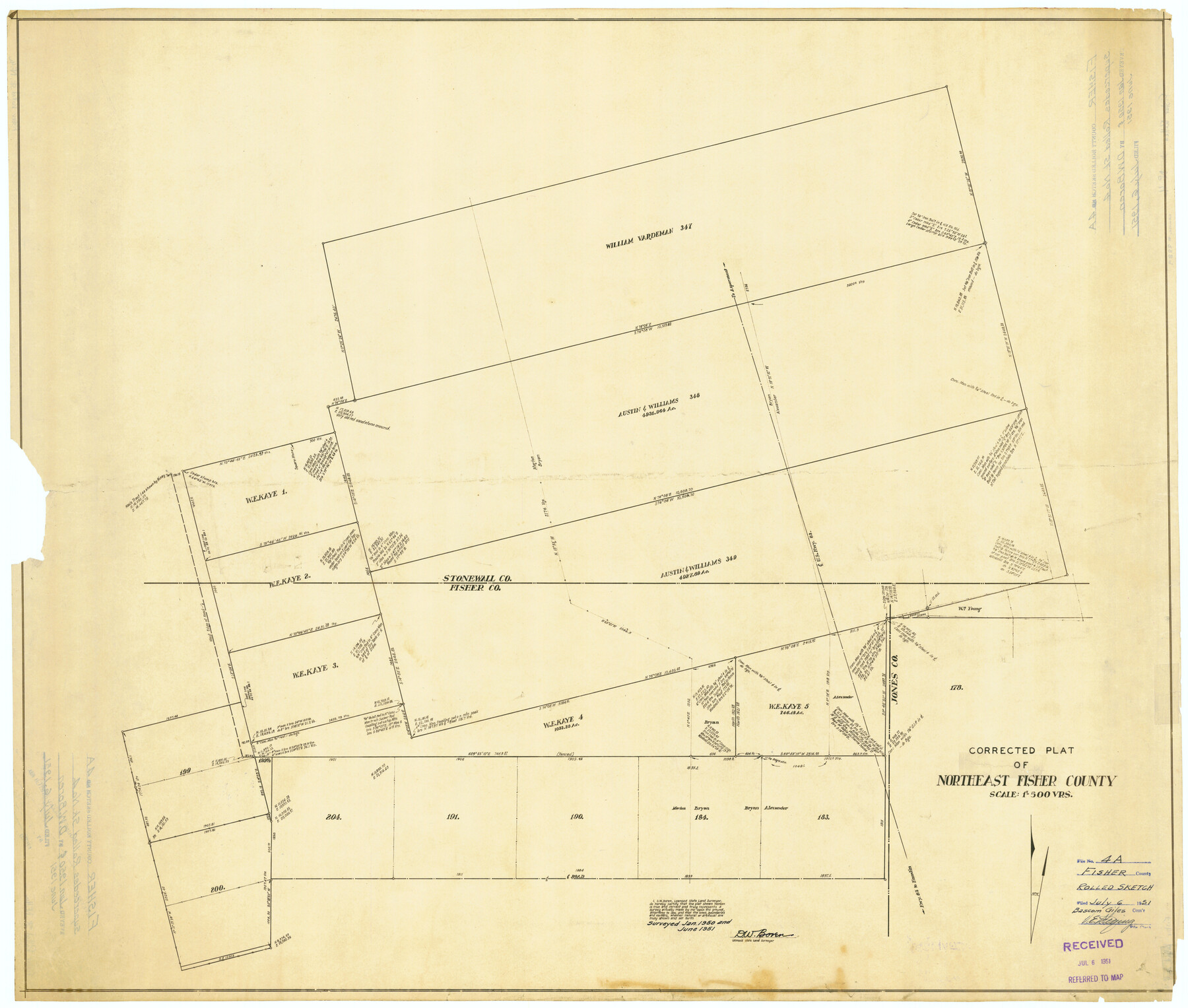
Fisher County Rolled Sketch 4A
Corrected plat of Northeast Fisher County
-
Map/Doc
8889
-
Collection
General Map Collection
-
Object Dates
1951 (Creation Date)
1951/7/6 (File Date)
-
People and Organizations
D.W. Boren (Surveyor/Engineer)
-
Counties
Fisher
-
Subjects
Surveying Rolled Sketch
-
Height x Width
31.0 x 36.6 inches
78.7 x 93.0 cm
-
Medium
van dyke/brownline/sepia
-
Scale
1" = 500 varas
-
Comments
Supercedes Fisher County Rolled Sketch 4 (8888).
Related maps
Fisher County Rolled Sketch 4

Print $20.00
- Digital $50.00
Fisher County Rolled Sketch 4
1950
Size 32.4 x 37.5 inches
Map/Doc 8888
Part of: General Map Collection
Hardeman County

Print $20.00
- Digital $50.00
Hardeman County
1891
Size 24.9 x 19.9 inches
Map/Doc 4560
Wise County Working Sketch 28

Print $40.00
- Digital $50.00
Wise County Working Sketch 28
1996
Size 37.5 x 48.8 inches
Map/Doc 72642
Lampasas County Sketch File 16 1/2

Print $4.00
- Digital $50.00
Lampasas County Sketch File 16 1/2
Size 8.4 x 8.6 inches
Map/Doc 29428
Wichita County Working Sketch 23

Print $20.00
- Digital $50.00
Wichita County Working Sketch 23
1963
Size 28.4 x 30.8 inches
Map/Doc 72533
Blanco County Boundary File 1

Print $20.00
- Digital $50.00
Blanco County Boundary File 1
Size 11.6 x 23.1 inches
Map/Doc 50539
University Lands Blocks 14 & 15, Crockett & Upton Counties

Print $20.00
- Digital $50.00
University Lands Blocks 14 & 15, Crockett & Upton Counties
1936
Size 36.6 x 25.5 inches
Map/Doc 2446
Upshur County Sketch File 17

Print $62.00
- Digital $50.00
Upshur County Sketch File 17
1965
Size 35.4 x 31.8 inches
Map/Doc 10410
El Paso County Working Sketch 6

Print $20.00
- Digital $50.00
El Paso County Working Sketch 6
1928
Size 25.4 x 16.7 inches
Map/Doc 69028
Jefferson County Rolled Sketch 52

Print $40.00
- Digital $50.00
Jefferson County Rolled Sketch 52
Size 28.2 x 52.9 inches
Map/Doc 9308
Grayson County Boundary File 2a

Print $60.00
- Digital $50.00
Grayson County Boundary File 2a
Size 43.7 x 9.8 inches
Map/Doc 53938
Hutchinson County Working Sketch 21

Print $20.00
- Digital $50.00
Hutchinson County Working Sketch 21
1965
Size 35.0 x 40.8 inches
Map/Doc 66381
Edwards County Working Sketch 140

Print $20.00
- Digital $50.00
Edwards County Working Sketch 140
2014
Size 36.1 x 41.1 inches
Map/Doc 93665
You may also like
Knox County Working Sketch 20

Print $20.00
- Digital $50.00
Knox County Working Sketch 20
2012
Size 40.2 x 36.9 inches
Map/Doc 93389
Carte de la Louisiane et Pays Voisins Pour servir a l'Histoire Generale des Voyages

Print $20.00
Carte de la Louisiane et Pays Voisins Pour servir a l'Histoire Generale des Voyages
1757
Size 9.6 x 14.9 inches
Map/Doc 94572
Grant of Miguel Rabago

Print $2.00
- Digital $50.00
Grant of Miguel Rabago
Size 8.6 x 8.4 inches
Map/Doc 76047
Bexar County Rolled Sketch 3

Print $20.00
- Digital $50.00
Bexar County Rolled Sketch 3
1873
Size 25.5 x 18.0 inches
Map/Doc 5136
Flight Mission No. BRA-7M, Frame 31, Jefferson County

Print $20.00
- Digital $50.00
Flight Mission No. BRA-7M, Frame 31, Jefferson County
1953
Size 18.5 x 22.3 inches
Map/Doc 85482
Navarro County Sketch File 5

Print $6.00
- Digital $50.00
Navarro County Sketch File 5
1852
Size 5.5 x 8.1 inches
Map/Doc 32307
Comanche County Sketch File 28

Print $6.00
- Digital $50.00
Comanche County Sketch File 28
Size 6.1 x 11.7 inches
Map/Doc 19117
Gillespie County Sketch File 4

Print $4.00
- Digital $50.00
Gillespie County Sketch File 4
1860
Size 12.7 x 8.2 inches
Map/Doc 24135
[Sketch for Mineral Application 16777]
![65653, [Sketch for Mineral Application 16777], General Map Collection](https://historictexasmaps.com/wmedia_w700/maps/65653-1.tif.jpg)
Print $40.00
- Digital $50.00
[Sketch for Mineral Application 16777]
Size 19.5 x 79.9 inches
Map/Doc 65653
Fractional Township No. 7 South Range No. 6 West of the Indian Meridian, Indian Territory

Print $20.00
- Digital $50.00
Fractional Township No. 7 South Range No. 6 West of the Indian Meridian, Indian Territory
1898
Size 19.2 x 24.2 inches
Map/Doc 75188
Nolan County Sketch File 19

Print $20.00
- Digital $50.00
Nolan County Sketch File 19
1937
Size 17.3 x 19.6 inches
Map/Doc 42167
Stonewall County Sketch File 30

Print $120.00
- Digital $50.00
Stonewall County Sketch File 30
1986
Size 24.5 x 35.3 inches
Map/Doc 12370