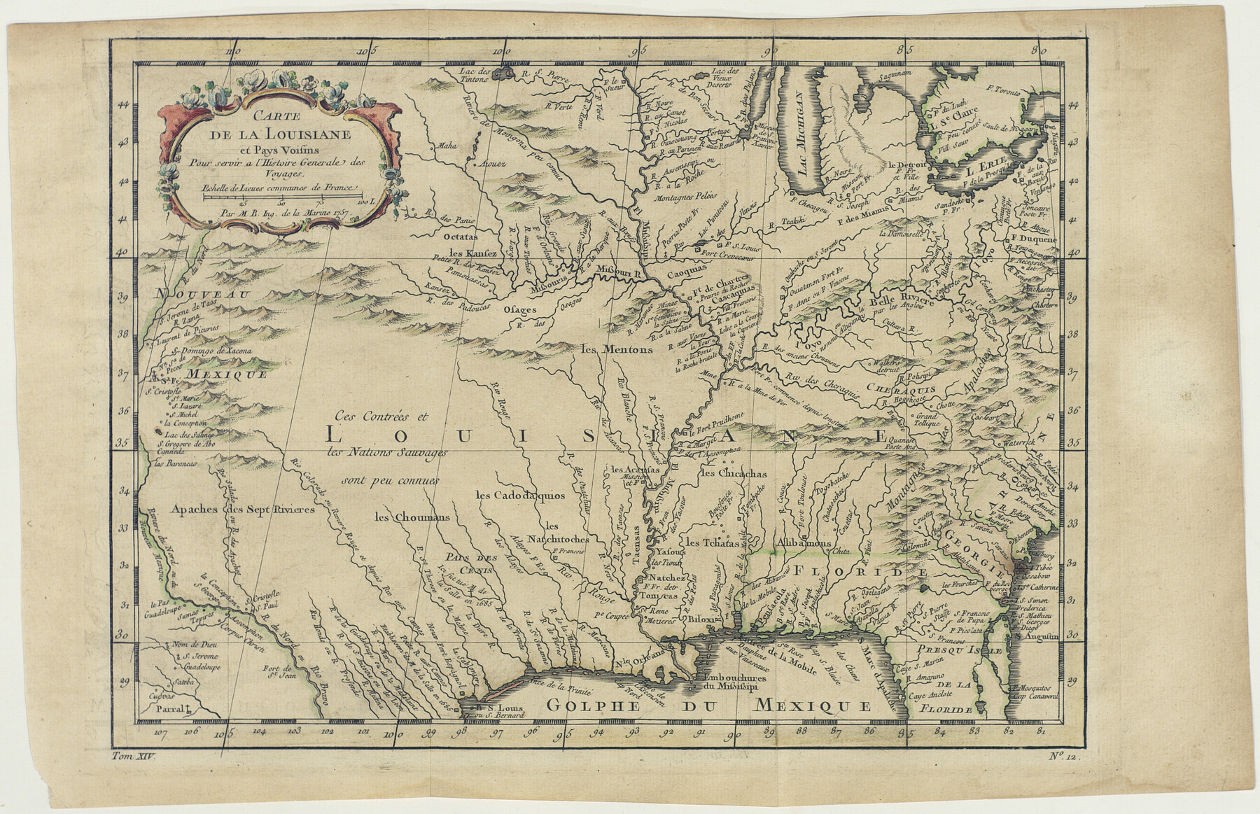
Carte de la Louisiane et Pays Voisins Pour servir a l'Histoire Generale des Voyages
-
Map/Doc
94572
-
Collection
Non-GLO Digital Images
-
Object Dates
1757 (Creation Date)
-
People and Organizations
Jacques Nicolas Bellin (Cartographer)
-
Subjects
North America Spanish Texas
-
Height x Width
9.6 x 14.9 inches
24.4 x 37.9 cm
-
Medium
digital image
-
Comments
Image provided by Ambassador Chase Untermeyer in June 2018.
Part of: Non-GLO Digital Images

[Movements & Objectives of the 143rd & 144th Infantry on October 12-13, 1918, Appendix E, No.1]
![94126, [Movements & Objectives of the 143rd & 144th Infantry on October 12-13, 1918, Appendix E, No.1], Non-GLO Digital Images](https://historictexasmaps.com/wmedia_w700/maps/94126-1.tif.jpg)
Print $20.00
[Movements & Objectives of the 143rd & 144th Infantry on October 12-13, 1918, Appendix E, No.1]
1918
Size 22.5 x 20.0 inches
Map/Doc 94126
A general map of Great Britain and Ireland with part of Holland, Flanders, France & agreable to modern history

Print $20.00
A general map of Great Britain and Ireland with part of Holland, Flanders, France & agreable to modern history
1750
Size 21.6 x 25.7 inches
Map/Doc 97435
Carta Particular de las Costas Setentrionales del Seno Mexicano que comprehende las de la Florída Ocidental las Márgenes de la Luisiana y toda la rivera que sigue por la Bahía de S. Bernardo y el Rio Bravo del Norte hasta la Laguna Madre

Carta Particular de las Costas Setentrionales del Seno Mexicano que comprehende las de la Florída Ocidental las Márgenes de la Luisiana y toda la rivera que sigue por la Bahía de S. Bernardo y el Rio Bravo del Norte hasta la Laguna Madre
1807
Size 27.3 x 40.3 inches
Map/Doc 94565
Map of North America engraved to illustrate Mitchell's school and family geography

Print $20.00
Map of North America engraved to illustrate Mitchell's school and family geography
1839
Size 11.3 x 8.7 inches
Map/Doc 93552
Map of Texas and part of New Mexico

Print $20.00
Map of Texas and part of New Mexico
1857
Size 17.4 x 23.1 inches
Map/Doc 95284
Plano de la Villa y Presidio de S. Antonio de Vejar situado en la Provincia de Tejas en 29 grad. y 52 minutos de latitud bor. y 275° y 57' de long. contados desde de Meridiano d. Tenerife

Plano de la Villa y Presidio de S. Antonio de Vejar situado en la Provincia de Tejas en 29 grad. y 52 minutos de latitud bor. y 275° y 57' de long. contados desde de Meridiano d. Tenerife
1768
Size 16.8 x 21.2 inches
Map/Doc 96564
The Official Map of the City of El Paso, State of Texas

Print $20.00
The Official Map of the City of El Paso, State of Texas
1889
Size 41.9 x 46.2 inches
Map/Doc 89618
Bird's Eye View of La Grange, Fayette County, Texas

Print $20.00
Bird's Eye View of La Grange, Fayette County, Texas
1880
Size 24.1 x 31.2 inches
Map/Doc 89096
Preliminary Survey of the Entrance to the Rio Grande, Texas

Print $20.00
Preliminary Survey of the Entrance to the Rio Grande, Texas
1854
Size 14.2 x 14.9 inches
Map/Doc 95283
Carta Particular de la Parte sur del Seno Mexicano que comprehende las Cóstas de Yucatan y Sonda de Campeche, las de Tabasco, Veracruz y Tamaulipas

Carta Particular de la Parte sur del Seno Mexicano que comprehende las Cóstas de Yucatan y Sonda de Campeche, las de Tabasco, Veracruz y Tamaulipas
1825
Size 26.6 x 38.5 inches
Map/Doc 94567
Bird's Eye View of the City of Brenham, Washington County, Texas

Print $20.00
Bird's Eye View of the City of Brenham, Washington County, Texas
1881
Size 19.4 x 26.7 inches
Map/Doc 89076
You may also like
Throckmorton County Working Sketch 8

Print $20.00
- Digital $50.00
Throckmorton County Working Sketch 8
1958
Size 21.6 x 30.4 inches
Map/Doc 62117
Texas-Indian Territory Gainesville Quadrangle

Print $20.00
- Digital $50.00
Texas-Indian Territory Gainesville Quadrangle
1913
Size 20.4 x 16.9 inches
Map/Doc 75103
Angelina County Sketch File 11f

Print $4.00
- Digital $50.00
Angelina County Sketch File 11f
1885
Size 8.2 x 12.6 inches
Map/Doc 12954
Tom Green County Sketch File 55 1/2

Print $20.00
- Digital $50.00
Tom Green County Sketch File 55 1/2
1886
Size 26.4 x 13.6 inches
Map/Doc 12443
Henderson County Sketch File 7

Print $4.00
- Digital $50.00
Henderson County Sketch File 7
1854
Size 8.6 x 8.6 inches
Map/Doc 26329
Calhoun County Sketch File 12

Print $120.00
- Digital $50.00
Calhoun County Sketch File 12
Size 23.0 x 36.9 inches
Map/Doc 11033
Leon County Working Sketch 11

Print $20.00
- Digital $50.00
Leon County Working Sketch 11
1952
Size 21.1 x 35.0 inches
Map/Doc 70410
Hudspeth County Working Sketch 41

Print $20.00
- Digital $50.00
Hudspeth County Working Sketch 41
1981
Size 18.3 x 37.1 inches
Map/Doc 66326
County Map of Texas, and Indian Territory

Print $20.00
County Map of Texas, and Indian Territory
1872
Size 18.9 x 16.1 inches
Map/Doc 88820
Smith County Working Sketch 10

Print $20.00
- Digital $50.00
Smith County Working Sketch 10
1952
Size 33.4 x 24.2 inches
Map/Doc 63895
[Blocks DT, P, CK, C2, and D7]
![91307, [Blocks DT, P, CK, C2, and D7], Twichell Survey Records](https://historictexasmaps.com/wmedia_w700/maps/91307-1.tif.jpg)
Print $20.00
- Digital $50.00
[Blocks DT, P, CK, C2, and D7]
Size 23.6 x 9.6 inches
Map/Doc 91307
Andrews County Rolled Sketch 28

Print $20.00
- Digital $50.00
Andrews County Rolled Sketch 28
1948
Size 17.0 x 25.5 inches
Map/Doc 77172