Oldham County Surveyor's Oath of Office

Print $3.00
Oldham County Surveyor's Oath of Office
1881
Size: 15.2 x 9.7 inches
47716
Velasco, Brazoria County, Texas

Print $40.00
Velasco, Brazoria County, Texas
1891
Size: 67.2 x 50.5 inches
77055
The Rand-McNally New Commercial Atlas Map of Texas

Print $20.00
The Rand-McNally New Commercial Atlas Map of Texas
1914
Size: 28.6 x 42.4 inches
78225
The Rand-McNally New Commercial Atlas Map of Texas

Print $20.00
The Rand-McNally New Commercial Atlas Map of Texas
1914
Size: 42.7 x 28.6 inches
78226

Mexico, California and Texas

Print $20.00
Mexico, California and Texas
1850
Size: 11.1 x 15.0 inches
82964
City of Round Rock, Texas

Print $20.00
City of Round Rock, Texas
1958
Size: 25.3 x 31.5 inches
87359
Map of the State of Texas Engraved to Illustrate Mitchell's School and Family Geography

Print $20.00
Map of the State of Texas Engraved to Illustrate Mitchell's School and Family Geography
1846
Size: 12.0 x 9.6 inches
87902
County Map of Texas, and Indian Territory

Print $20.00
County Map of Texas, and Indian Territory
1872
Size: 18.9 x 16.1 inches
88820
Map of the territory comprised between the Province of New Mexico and the fort of Natchitoches and Texas

Map of the territory comprised between the Province of New Mexico and the fort of Natchitoches and Texas
1789
Size: 8.9 x 15.3 inches
88888
Bird's Eye View of Abilene, Taylor County, Texas

Print $20.00
Bird's Eye View of Abilene, Taylor County, Texas
1883
Size: 23.6 x 30.7 inches
89071
Bird's Eye View of Bastrop, Bastrop County, Texas

Print $20.00
Bird's Eye View of Bastrop, Bastrop County, Texas
1887
Size: 18.8 x 25.7 inches
89073
Bird's Eye View of the City of Belton, Bell County, Texas

Print $20.00
Bird's Eye View of the City of Belton, Bell County, Texas
1881
Size: 18.5 x 23.8 inches
89074
Bird's Eye View of Brenham, Washington County, Texas

Print $20.00
Bird's Eye View of Brenham, Washington County, Texas
1873
Size: 20.0 x 25.7 inches
89075
Bird's Eye View of the City of Brenham, Washington County, Texas

Print $20.00
Bird's Eye View of the City of Brenham, Washington County, Texas
1881
Size: 19.4 x 26.7 inches
89076
Clarendon, Texas, Donley Co.

Print $20.00
Clarendon, Texas, Donley Co.
1890
Size: 15.7 x 26.6 inches
89078
Bird's Eye View of Cuero, De Witt County, Texas

Print $20.00
Bird's Eye View of Cuero, De Witt County, Texas
1881
Size: 18.4 x 25.5 inches
89079
Bird's Eye View of the City of Dallas, Texas

Print $20.00
Bird's Eye View of the City of Dallas, Texas
1872
Size: 18.6 x 25.6 inches
89080
Fort Worth, Tarrant Co[unty], Texas
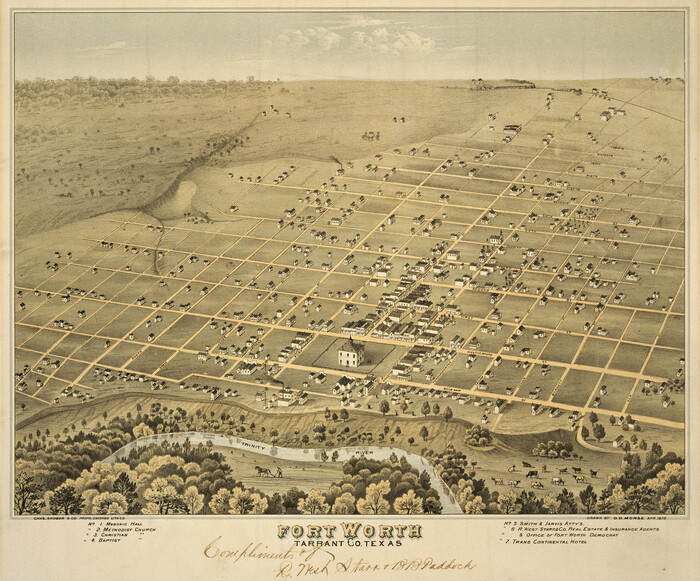
Print $20.00
Fort Worth, Tarrant Co[unty], Texas
1876
Size: 14.9 x 18.0 inches
89081
Fort Worth, Tex. "The Queen of the Prairies," County Seat of Tarrant County

Print $20.00
Fort Worth, Tex. "The Queen of the Prairies," County Seat of Tarrant County
1886
Size: 26.0 x 33.3 inches
89082
Perspective Map of Fort Worth, Tex.

Print $20.00
Perspective Map of Fort Worth, Tex.
1891
Size: 19.9 x 33.0 inches
89083
Bird's Eye View of the City of Gainesville Cooke County, Texas

Print $20.00
Bird's Eye View of the City of Gainesville Cooke County, Texas
1883
Size: 19.2 x 25.6 inches
89084
Bird's Eye View of the City of Galveston Texas

Print $20.00
Bird's Eye View of the City of Galveston Texas
1871
Size: 20.4 x 30.8 inches
89086
Bird's Eye View of Gatesville, Coryell County, Texas

Print $20.00
Bird's Eye View of Gatesville, Coryell County, Texas
1884
Size: 15.7 x 24.2 inches
89088
Greenville, Tex., County Seat of Hunt County

Print $20.00
Greenville, Tex., County Seat of Hunt County
1886
Size: 17.3 x 24.9 inches
89089
Oldham County Surveyor's Oath of Office
Print $3.00
Oldham County Surveyor's Oath of Office
1881
Oath of Office by W.S. Mabry for the role of Surveyor of Oldham County and Oldham Land District.
-
Size
15.2 x 9.7 inches
-
Map/Doc
47716
-
Creation Date
1881
Velasco, Brazoria County, Texas
Print $40.00
Velasco, Brazoria County, Texas
1891
-
Size
67.2 x 50.5 inches
-
Map/Doc
77055
-
Creation Date
1891
The Rand-McNally New Commercial Atlas Map of Texas
Print $20.00
The Rand-McNally New Commercial Atlas Map of Texas
1914
-
Size
28.6 x 42.4 inches
-
Map/Doc
78225
-
Creation Date
1914
The Rand-McNally New Commercial Atlas Map of Texas
Print $20.00
The Rand-McNally New Commercial Atlas Map of Texas
1914
-
Size
42.7 x 28.6 inches
-
Map/Doc
78226
-
Creation Date
1914
Coleman County

Print $40.00
Coleman County
1949
-
Size
68.6 x 43.1 inches
-
Map/Doc
81518
-
Creation Date
1949
Mexico, California and Texas
Print $20.00
Mexico, California and Texas
1850
-
Size
11.1 x 15.0 inches
-
Map/Doc
82964
-
Creation Date
1850
[Town plat of San Marcos]
![83002, [Town plat of San Marcos], Non-GLO Digital Images](https://historictexasmaps.com/wmedia_w700/maps/83002.tif.jpg)
Print $20.00
[Town plat of San Marcos]
-
Size
15.8 x 10.1 inches
-
Map/Doc
83002
City of Round Rock, Texas
Print $20.00
City of Round Rock, Texas
1958
-
Size
25.3 x 31.5 inches
-
Map/Doc
87359
-
Creation Date
1958
Map of the State of Texas Engraved to Illustrate Mitchell's School and Family Geography
Print $20.00
Map of the State of Texas Engraved to Illustrate Mitchell's School and Family Geography
1846
-
Size
12.0 x 9.6 inches
-
Map/Doc
87902
-
Creation Date
1846
County Map of Texas, and Indian Territory
Print $20.00
County Map of Texas, and Indian Territory
1872
-
Size
18.9 x 16.1 inches
-
Map/Doc
88820
-
Creation Date
1872
Map of the territory comprised between the Province of New Mexico and the fort of Natchitoches and Texas
Map of the territory comprised between the Province of New Mexico and the fort of Natchitoches and Texas
1789
-
Size
8.9 x 15.3 inches
-
Map/Doc
88888
-
Creation Date
1789
Bird's Eye View of Abilene, Taylor County, Texas
Print $20.00
Bird's Eye View of Abilene, Taylor County, Texas
1883
-
Size
23.6 x 30.7 inches
-
Map/Doc
89071
-
Creation Date
1883
Alvord, Texas

Print $20.00
Alvord, Texas
1890
-
Size
12.6 x 19.3 inches
-
Map/Doc
89072
-
Creation Date
1890
Bird's Eye View of Bastrop, Bastrop County, Texas
Print $20.00
Bird's Eye View of Bastrop, Bastrop County, Texas
1887
-
Size
18.8 x 25.7 inches
-
Map/Doc
89073
-
Creation Date
1887
Bird's Eye View of the City of Belton, Bell County, Texas
Print $20.00
Bird's Eye View of the City of Belton, Bell County, Texas
1881
-
Size
18.5 x 23.8 inches
-
Map/Doc
89074
-
Creation Date
1881
Bird's Eye View of Brenham, Washington County, Texas
Print $20.00
Bird's Eye View of Brenham, Washington County, Texas
1873
-
Size
20.0 x 25.7 inches
-
Map/Doc
89075
-
Creation Date
1873
Bird's Eye View of the City of Brenham, Washington County, Texas
Print $20.00
Bird's Eye View of the City of Brenham, Washington County, Texas
1881
-
Size
19.4 x 26.7 inches
-
Map/Doc
89076
-
Creation Date
1881
Childress, Texas

Print $20.00
Childress, Texas
1890
-
Size
12.3 x 17.9 inches
-
Map/Doc
89077
-
Creation Date
1890
Clarendon, Texas, Donley Co.
Print $20.00
Clarendon, Texas, Donley Co.
1890
-
Size
15.7 x 26.6 inches
-
Map/Doc
89078
-
Creation Date
1890
Bird's Eye View of Cuero, De Witt County, Texas
Print $20.00
Bird's Eye View of Cuero, De Witt County, Texas
1881
-
Size
18.4 x 25.5 inches
-
Map/Doc
89079
-
Creation Date
1881
Bird's Eye View of the City of Dallas, Texas
Print $20.00
Bird's Eye View of the City of Dallas, Texas
1872
-
Size
18.6 x 25.6 inches
-
Map/Doc
89080
-
Creation Date
1872
Fort Worth, Tarrant Co[unty], Texas
Print $20.00
Fort Worth, Tarrant Co[unty], Texas
1876
-
Size
14.9 x 18.0 inches
-
Map/Doc
89081
-
Creation Date
1876
Fort Worth, Tex. "The Queen of the Prairies," County Seat of Tarrant County
Print $20.00
Fort Worth, Tex. "The Queen of the Prairies," County Seat of Tarrant County
1886
-
Size
26.0 x 33.3 inches
-
Map/Doc
89082
-
Creation Date
1886
Perspective Map of Fort Worth, Tex.
Print $20.00
Perspective Map of Fort Worth, Tex.
1891
-
Size
19.9 x 33.0 inches
-
Map/Doc
89083
-
Creation Date
1891
Bird's Eye View of the City of Gainesville Cooke County, Texas
Print $20.00
Bird's Eye View of the City of Gainesville Cooke County, Texas
1883
-
Size
19.2 x 25.6 inches
-
Map/Doc
89084
-
Creation Date
1883
Bird's Eye View of the City of Galveston Texas
Print $20.00
Bird's Eye View of the City of Galveston Texas
1871
-
Size
20.4 x 30.8 inches
-
Map/Doc
89086
-
Creation Date
1871
Galveston, Texas

Print $20.00
Galveston, Texas
1885
-
Size
18.7 x 27.1 inches
-
Map/Doc
89087
-
Creation Date
1885
Bird's Eye View of Gatesville, Coryell County, Texas
Print $20.00
Bird's Eye View of Gatesville, Coryell County, Texas
1884
-
Size
15.7 x 24.2 inches
-
Map/Doc
89088
-
Creation Date
1884
Greenville, Tex., County Seat of Hunt County
Print $20.00
Greenville, Tex., County Seat of Hunt County
1886
-
Size
17.3 x 24.9 inches
-
Map/Doc
89089
-
Creation Date
1886