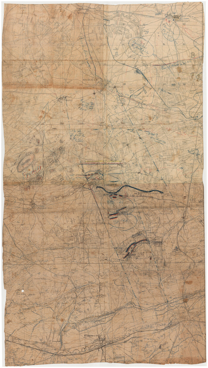
[WWI Topographic Planning Map of the Ardennes]
Print $20.00
[WWI Topographic Planning Map of the Ardennes]
1918
Size: 35.8 x 20.2 inches
94129
[WWI Topographic Planning Map of the Ardennes department] - Verso
Print $20.00
[WWI Topographic Planning Map of the Ardennes department] - Verso
1918
Size: 35.9 x 20.4 inches
94130
[Stephen F. Austin's Map of Texas]
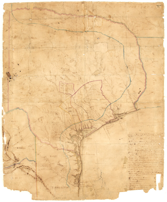
[Stephen F. Austin's Map of Texas]
1829
Size: 21.7 x 17.9 inches
95825
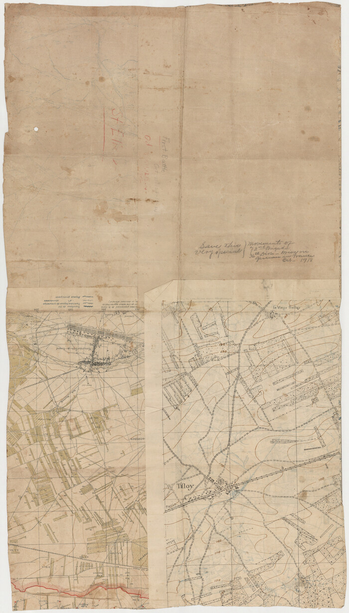
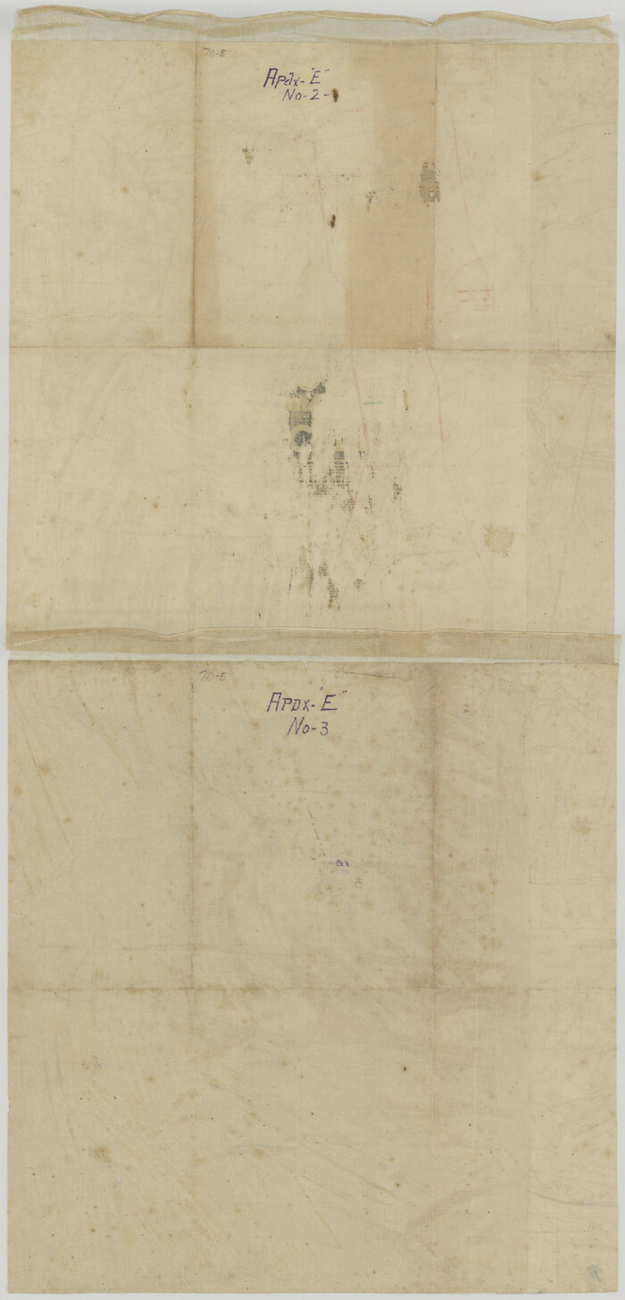
[Movements & Objectives of the 143rd & 144th Infantry on October 9-11, 1918, Appendix E, Nos.2 and 3] - Verso
Print $20.00
[Movements & Objectives of the 143rd & 144th Infantry on October 9-11, 1918, Appendix E, Nos.2 and 3] - Verso
1918
Size: 41.9 x 20.2 inches
94132
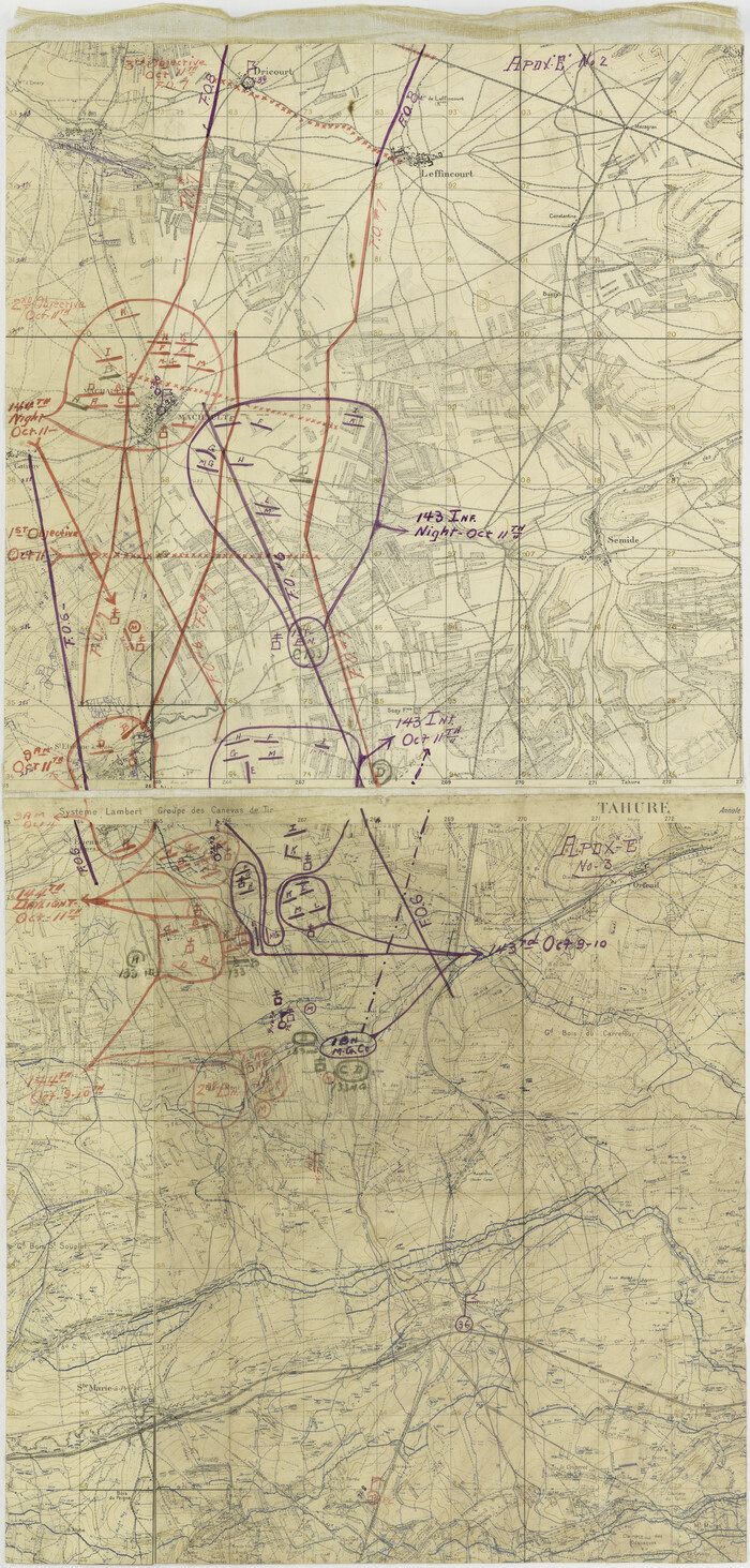
[Movements & Objectives of the 143rd & 144th Infantry on October 9-11, 1918, Appendix E, Nos.2 and 3]
Print $20.00
[Movements & Objectives of the 143rd & 144th Infantry on October 9-11, 1918, Appendix E, Nos.2 and 3]
1918
Size: 41.6 x 19.9 inches
94131
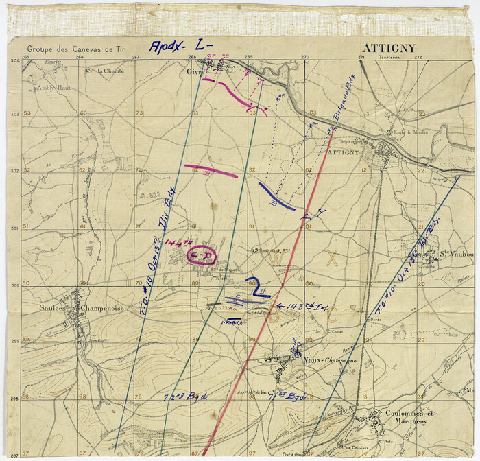
[Movements & Objectives of the 143rd & 144th Infantry on October 13, 1918, Appendix L]
Print $20.00
[Movements & Objectives of the 143rd & 144th Infantry on October 13, 1918, Appendix L]
1918
Size: 16.1 x 16.8 inches
94124
[Movements & Objectives of the 143rd & 144th Infantry on October 12-13, 1918] - Verso
Print $20.00
[Movements & Objectives of the 143rd & 144th Infantry on October 12-13, 1918] - Verso
1918
Size: 42.4 x 30.0 inches
94136
[Movements & Objectives of the 143rd & 144th Infantry on October 12-13, 1918]
Print $20.00
[Movements & Objectives of the 143rd & 144th Infantry on October 12-13, 1918]
1918
Size: 42.4 x 30.0 inches
94135
[Movements & Objectives of the 143rd & 144th Infantry on October 12-13, 1918, Appendix E, No.1]
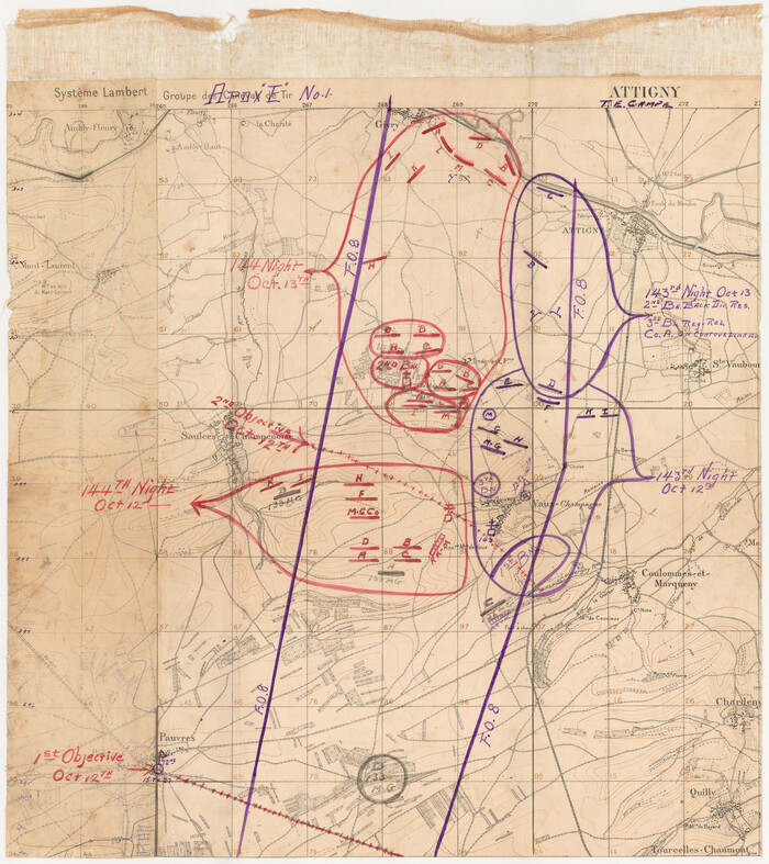
Print $20.00
[Movements & Objectives of the 143rd & 144th Infantry on October 12-13, 1918, Appendix E, No.1]
1918
Size: 22.5 x 20.0 inches
94126
[Movements & Objectives of the 143rd & 144th Infantry and many other divisions and regiments, 1918] - Verso

Print $40.00
[Movements & Objectives of the 143rd & 144th Infantry and many other divisions and regiments, 1918] - Verso
1918
Size: 37.2 x 63.9 inches
94139
[Movements & Objectives of the 143rd & 144th Infantry and many other divisions and regiments, 1918]
Print $40.00
[Movements & Objectives of the 143rd & 144th Infantry and many other divisions and regiments, 1918]
1918
Size: 64.2 x 37.5 inches
94138
[Movements & Objectives of the 143rd & 144th Infantry & 133rd Machine Gun Battalion on October 8-9, 1918, Appendix E, No. 4] - Verso
Print $20.00
[Movements & Objectives of the 143rd & 144th Infantry & 133rd Machine Gun Battalion on October 8-9, 1918, Appendix E, No. 4] - Verso
1918
Size: 21.5 x 20.0 inches
94134
[Movements & Objectives of the 143rd & 144th Infantry & 133rd Machine Gun Battalion on October 8-9, 1918, Appendix E, No. 4]
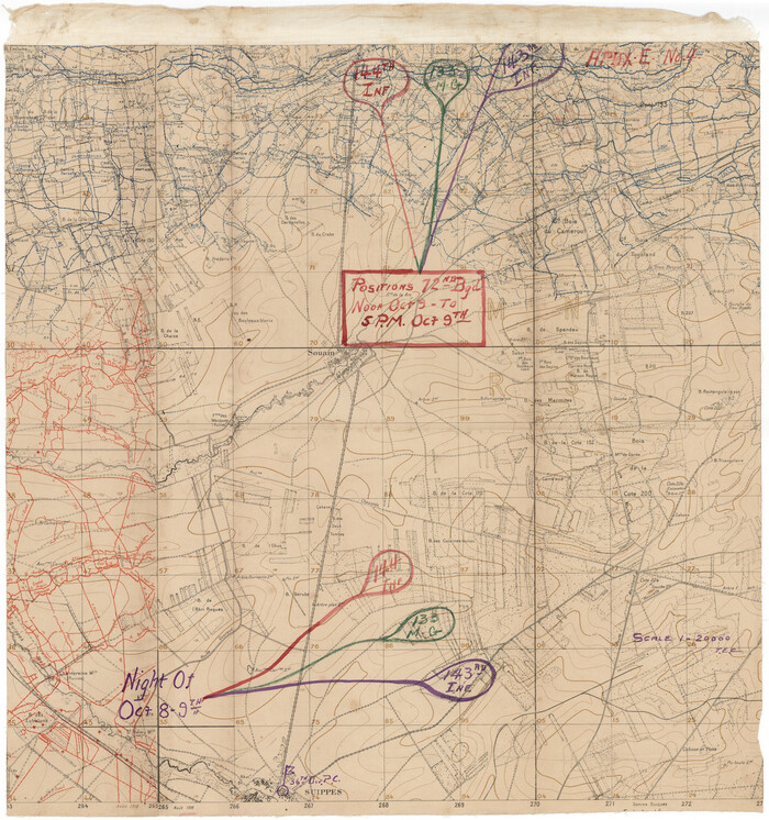
Print $20.00
[Movements & Objectives of the 143rd & 144th Infantry & 133rd Machine Gun Battalion on October 8-9, 1918, Appendix E, No. 4]
1918
Size: 21.5 x 20.2 inches
94133
[Divisional Boundary and Brigade Boundary on October 22, 1918, Appendix P]
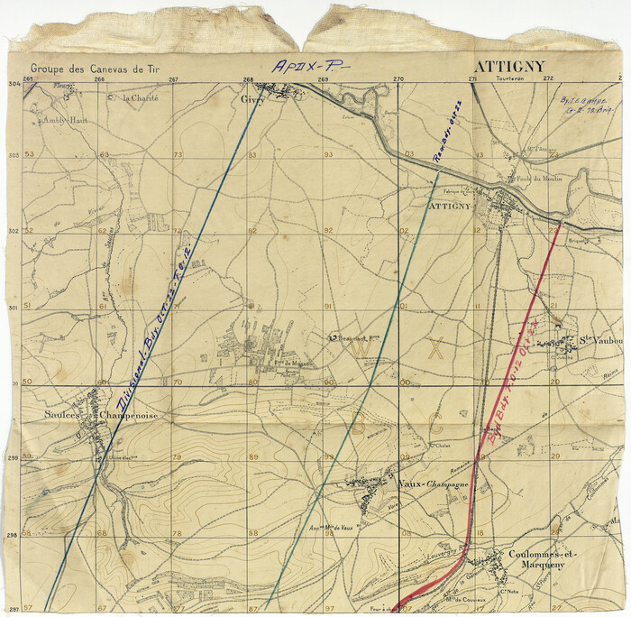
Print $20.00
[Divisional Boundary and Brigade Boundary on October 22, 1918, Appendix P]
1918
Size: 16.2 x 16.7 inches
94125
[Defensive Positions of the 143rd & 144th Infantry on October 14, 1918]
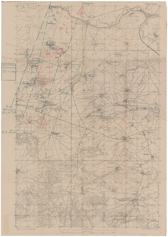
Print $20.00
[Defensive Positions of the 143rd & 144th Infantry on October 14, 1918]
1918
Size: 42.2 x 30.0 inches
94137
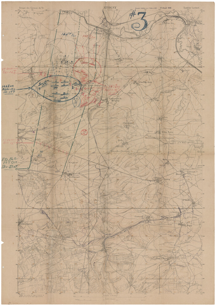
[1/4 of a WWI French map of Attigny used by the 142nd Infantry for planning purposes for the Battle of Forest Ferme (farm)]
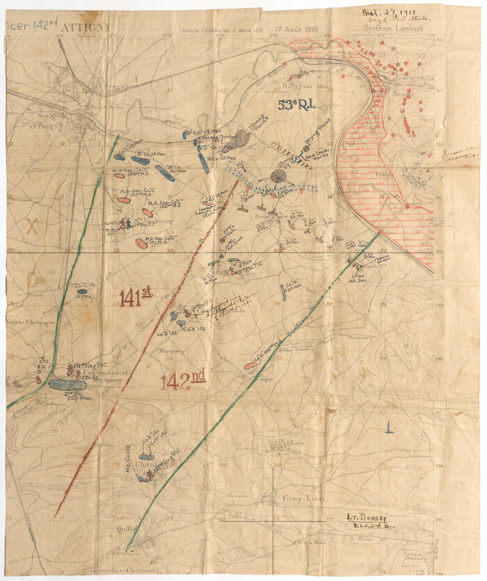
Print $20.00
[1/4 of a WWI French map of Attigny used by the 142nd Infantry for planning purposes for the Battle of Forest Ferme (farm)]
1918
Size: 21.1 x 17.7 inches
96642

Waco, Tex., County Seat of McLennan Co.

Print $20.00
Waco, Tex., County Seat of McLennan Co.
1886
Size: 23.1 x 32.7 inches
89212
Velasco, Brazoria County, Texas

Print $40.00
Velasco, Brazoria County, Texas
1891
Size: 67.2 x 50.5 inches
77055
The Scarborough Company's New Railroad, Post Office & County Map of Texas, Oklahoma and Indian Territory Compiled from the Latest Government Surveys and Original Sources

Print $20.00
The Scarborough Company's New Railroad, Post Office & County Map of Texas, Oklahoma and Indian Territory Compiled from the Latest Government Surveys and Original Sources
1904
Size: 43.1 x 47.8 inches
93967
The Rand-McNally New Commercial Atlas Map of Texas

Print $20.00
The Rand-McNally New Commercial Atlas Map of Texas
1914
Size: 28.6 x 42.4 inches
78225
The Rand-McNally New Commercial Atlas Map of Texas

Print $20.00
The Rand-McNally New Commercial Atlas Map of Texas
1914
Size: 42.7 x 28.6 inches
78226
The Official Map of the City of El Paso, State of Texas

Print $20.00
The Official Map of the City of El Paso, State of Texas
1889
Size: 42.2 x 50.5 inches
89615
The Official Map of the City of El Paso, State of Texas

Print $20.00
The Official Map of the City of El Paso, State of Texas
1889
Size: 42.1 x 49.6 inches
89616
The Official Map of the City of El Paso, State of Texas

Print $20.00
The Official Map of the City of El Paso, State of Texas
1889
Size: 42.4 x 54.4 inches
89617
The Official Map of the City of El Paso, State of Texas

Print $20.00
The Official Map of the City of El Paso, State of Texas
1889
Size: 41.9 x 46.2 inches
89618
[WWI Topographic Planning Map of the Ardennes]
Print $20.00
[WWI Topographic Planning Map of the Ardennes]
1918
-
Size
35.8 x 20.2 inches
-
Map/Doc
94129
-
Creation Date
1918
[WWI Topographic Planning Map of the Ardennes department] - Verso
Print $20.00
[WWI Topographic Planning Map of the Ardennes department] - Verso
1918
-
Size
35.9 x 20.4 inches
-
Map/Doc
94130
-
Creation Date
1918
[Town plat of San Marcos]
![83002, [Town plat of San Marcos], Non-GLO Digital Images](https://historictexasmaps.com/wmedia_w700/maps/83002.tif.jpg)
Print $20.00
[Town plat of San Marcos]
-
Size
15.8 x 10.1 inches
-
Map/Doc
83002
[Stephen F. Austin's Map of Texas]
[Stephen F. Austin's Map of Texas]
1829
-
Size
21.7 x 17.9 inches
-
Map/Doc
95825
-
Creation Date
1829
[Movements & Objectives of the 143rd & 144th Infantry on October 9-11, 1918, Appendix E, Nos.2 and 3] - Verso
Print $20.00
[Movements & Objectives of the 143rd & 144th Infantry on October 9-11, 1918, Appendix E, Nos.2 and 3] - Verso
1918
-
Size
41.9 x 20.2 inches
-
Map/Doc
94132
-
Creation Date
1918
[Movements & Objectives of the 143rd & 144th Infantry on October 9-11, 1918, Appendix E, Nos.2 and 3]
Print $20.00
[Movements & Objectives of the 143rd & 144th Infantry on October 9-11, 1918, Appendix E, Nos.2 and 3]
1918
-
Size
41.6 x 19.9 inches
-
Map/Doc
94131
-
Creation Date
1918
[Movements & Objectives of the 143rd & 144th Infantry on October 13, 1918, Appendix L]
Print $20.00
[Movements & Objectives of the 143rd & 144th Infantry on October 13, 1918, Appendix L]
1918
-
Size
16.1 x 16.8 inches
-
Map/Doc
94124
-
Creation Date
1918
[Movements & Objectives of the 143rd & 144th Infantry on October 12-13, 1918] - Verso
Print $20.00
[Movements & Objectives of the 143rd & 144th Infantry on October 12-13, 1918] - Verso
1918
-
Size
42.4 x 30.0 inches
-
Map/Doc
94136
-
Creation Date
1918
[Movements & Objectives of the 143rd & 144th Infantry on October 12-13, 1918]
Print $20.00
[Movements & Objectives of the 143rd & 144th Infantry on October 12-13, 1918]
1918
-
Size
42.4 x 30.0 inches
-
Map/Doc
94135
-
Creation Date
1918
[Movements & Objectives of the 143rd & 144th Infantry on October 12-13, 1918, Appendix E, No.1]
Print $20.00
[Movements & Objectives of the 143rd & 144th Infantry on October 12-13, 1918, Appendix E, No.1]
1918
-
Size
22.5 x 20.0 inches
-
Map/Doc
94126
-
Creation Date
1918
[Movements & Objectives of the 143rd & 144th Infantry and many other divisions and regiments, 1918] - Verso
Print $40.00
[Movements & Objectives of the 143rd & 144th Infantry and many other divisions and regiments, 1918] - Verso
1918
-
Size
37.2 x 63.9 inches
-
Map/Doc
94139
-
Creation Date
1918
[Movements & Objectives of the 143rd & 144th Infantry and many other divisions and regiments, 1918]
Print $40.00
[Movements & Objectives of the 143rd & 144th Infantry and many other divisions and regiments, 1918]
1918
-
Size
64.2 x 37.5 inches
-
Map/Doc
94138
-
Creation Date
1918
[Movements & Objectives of the 143rd & 144th Infantry & 133rd Machine Gun Battalion on October 8-9, 1918, Appendix E, No. 4] - Verso
Print $20.00
[Movements & Objectives of the 143rd & 144th Infantry & 133rd Machine Gun Battalion on October 8-9, 1918, Appendix E, No. 4] - Verso
1918
-
Size
21.5 x 20.0 inches
-
Map/Doc
94134
-
Creation Date
1918
[Movements & Objectives of the 143rd & 144th Infantry & 133rd Machine Gun Battalion on October 8-9, 1918, Appendix E, No. 4]
Print $20.00
[Movements & Objectives of the 143rd & 144th Infantry & 133rd Machine Gun Battalion on October 8-9, 1918, Appendix E, No. 4]
1918
-
Size
21.5 x 20.2 inches
-
Map/Doc
94133
-
Creation Date
1918
[Divisional Boundary and Brigade Boundary on October 22, 1918, Appendix P]
Print $20.00
[Divisional Boundary and Brigade Boundary on October 22, 1918, Appendix P]
1918
-
Size
16.2 x 16.7 inches
-
Map/Doc
94125
-
Creation Date
1918
[Defensive Positions of the 143rd & 144th Infantry on October 14, 1918]
Print $20.00
[Defensive Positions of the 143rd & 144th Infantry on October 14, 1918]
1918
-
Size
42.2 x 30.0 inches
-
Map/Doc
94137
-
Creation Date
1918
[1/4 of a WWI French map of Attigny used by the 142nd Infantry for planning purposes for the Battle of Forest Ferme (farm)]
Print $20.00
[1/4 of a WWI French map of Attigny used by the 142nd Infantry for planning purposes for the Battle of Forest Ferme (farm)]
1918
-
Size
21.1 x 17.7 inches
-
Map/Doc
96642
-
Creation Date
1918
Wolfe City, Texas

Print $20.00
Wolfe City, Texas
1891
-
Size
14.5 x 20.5 inches
-
Map/Doc
89215
-
Creation Date
1891
Wichita Falls, Texas

Print $20.00
Wichita Falls, Texas
1890
-
Size
21.0 x 30.9 inches
-
Map/Doc
89214
-
Creation Date
1890
Whitewright, Texas

Print $20.00
Whitewright, Texas
1891
-
Size
14.3 x 24.3 inches
-
Map/Doc
89213
-
Creation Date
1891
Waco, Tex., County Seat of McLennan Co.
Print $20.00
Waco, Tex., County Seat of McLennan Co.
1886
-
Size
23.1 x 32.7 inches
-
Map/Doc
89212
-
Creation Date
1886
Velasco, Brazoria County, Texas
Print $40.00
Velasco, Brazoria County, Texas
1891
-
Size
67.2 x 50.5 inches
-
Map/Doc
77055
-
Creation Date
1891
The Scarborough Company's New Railroad, Post Office & County Map of Texas, Oklahoma and Indian Territory Compiled from the Latest Government Surveys and Original Sources
Print $20.00
The Scarborough Company's New Railroad, Post Office & County Map of Texas, Oklahoma and Indian Territory Compiled from the Latest Government Surveys and Original Sources
1904
-
Size
43.1 x 47.8 inches
-
Map/Doc
93967
-
Creation Date
1904
The Rand-McNally New Commercial Atlas Map of Texas
Print $20.00
The Rand-McNally New Commercial Atlas Map of Texas
1914
-
Size
28.6 x 42.4 inches
-
Map/Doc
78225
-
Creation Date
1914
The Rand-McNally New Commercial Atlas Map of Texas
Print $20.00
The Rand-McNally New Commercial Atlas Map of Texas
1914
-
Size
42.7 x 28.6 inches
-
Map/Doc
78226
-
Creation Date
1914
The Official Map of the City of El Paso, State of Texas
Print $20.00
The Official Map of the City of El Paso, State of Texas
1889
-
Size
42.2 x 50.5 inches
-
Map/Doc
89615
-
Creation Date
1889
The Official Map of the City of El Paso, State of Texas
Print $20.00
The Official Map of the City of El Paso, State of Texas
1889
-
Size
42.1 x 49.6 inches
-
Map/Doc
89616
-
Creation Date
1889
The Official Map of the City of El Paso, State of Texas
Print $20.00
The Official Map of the City of El Paso, State of Texas
1889
-
Size
42.4 x 54.4 inches
-
Map/Doc
89617
-
Creation Date
1889
The Official Map of the City of El Paso, State of Texas
Print $20.00
The Official Map of the City of El Paso, State of Texas
1889
-
Size
41.9 x 46.2 inches
-
Map/Doc
89618
-
Creation Date
1889