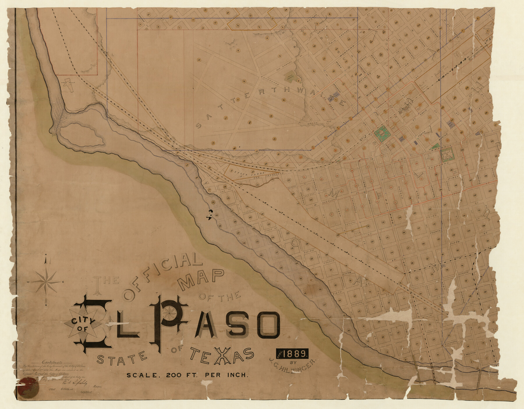
The Official Map of the City of El Paso, State of Texas
-
Map/Doc
89617
-
Collection
Non-GLO Digital Images
-
Object Dates
4/1889 (Creation Date)
-
People and Organizations
J.C. Hilzinger (Draftsman)
-
Counties
El Paso
-
Subjects
City
-
Height x Width
42.4 x 54.4 inches
107.7 x 138.2 cm
-
Medium
digital image
-
Scale
1" = 200 feet
-
Comments
See counters 89615, 89616, and 89618 for other segments of this map. See counter 89619 for digitally combined image. This map was adopted as the official map of the City of El Paso on April 5, 1889. Conservation funded in 2010 in honor of James R. Przepasnia.
Related maps
The Official Map of the City of El Paso, State of Texas

Print $20.00
The Official Map of the City of El Paso, State of Texas
1889
Size 42.2 x 50.5 inches
Map/Doc 89615
The Official Map of the City of El Paso, State of Texas

Print $20.00
The Official Map of the City of El Paso, State of Texas
1889
Size 42.1 x 49.6 inches
Map/Doc 89616
The Official Map of the City of El Paso, State of Texas

Print $20.00
The Official Map of the City of El Paso, State of Texas
1889
Size 41.9 x 46.2 inches
Map/Doc 89618
The Official Map of the City of El Paso, State of Texas

Print $40.00
The Official Map of the City of El Paso, State of Texas
1889
Size 83.6 x 97.2 inches
Map/Doc 89619
Part of: Non-GLO Digital Images
Carte de la Louisiane et du Cours du Mississipi

Print $20.00
Carte de la Louisiane et du Cours du Mississipi
1718
Size 16.6 x 21.8 inches
Map/Doc 89216
Carte de la Louisiane et Pays Voisins Pour servir a l'Histoire Generale des Voyages

Print $20.00
Carte de la Louisiane et Pays Voisins Pour servir a l'Histoire Generale des Voyages
1757
Size 9.6 x 14.9 inches
Map/Doc 94572
Bird's Eye View of Schulenburg, Fayette County, Texas

Print $20.00
Bird's Eye View of Schulenburg, Fayette County, Texas
1881
Size 18.6 x 31.0 inches
Map/Doc 89206
[Movements & Objectives of the 143rd & 144th Infantry & 133rd Machine Gun Battalion on October 8-9, 1918, Appendix E, No. 4]
![94133, [Movements & Objectives of the 143rd & 144th Infantry & 133rd Machine Gun Battalion on October 8-9, 1918, Appendix E, No. 4], Non-GLO Digital Images](https://historictexasmaps.com/wmedia_w700/maps/94133-1.tif.jpg)
Print $20.00
[Movements & Objectives of the 143rd & 144th Infantry & 133rd Machine Gun Battalion on October 8-9, 1918, Appendix E, No. 4]
1918
Size 21.5 x 20.2 inches
Map/Doc 94133
La Louisiane, Suivant les Nouvelles Observations de Messrs de l'Academie Royale des Sciences

Print $20.00
La Louisiane, Suivant les Nouvelles Observations de Messrs de l'Academie Royale des Sciences
1735
Size 9.1 x 11.9 inches
Map/Doc 95279
Map of Texas from the most recent authorities

Print $20.00
Map of Texas from the most recent authorities
1845
Size 13.5 x 17.1 inches
Map/Doc 94574
Map of Colorado City on the west bank of the Colorado River at the La Bahia crossing

Print $20.00
Map of Colorado City on the west bank of the Colorado River at the La Bahia crossing
1841
Size 24.4 x 32.5 inches
Map/Doc 94750
A New Map of ye North Parts of America according to the division thereof by the Articles of Peace in 1763

Print $20.00
A New Map of ye North Parts of America according to the division thereof by the Articles of Peace in 1763
1763
Size 8.5 x 11.3 inches
Map/Doc 95280
[Movements & Objectives of the 143rd & 144th Infantry on October 12-13, 1918, Appendix E, No.1]
![94126, [Movements & Objectives of the 143rd & 144th Infantry on October 12-13, 1918, Appendix E, No.1], Non-GLO Digital Images](https://historictexasmaps.com/wmedia_w700/maps/94126-1.tif.jpg)
Print $20.00
[Movements & Objectives of the 143rd & 144th Infantry on October 12-13, 1918, Appendix E, No.1]
1918
Size 22.5 x 20.0 inches
Map/Doc 94126
[Movements & Objectives of the 143rd & 144th Infantry on October 13, 1918, Appendix L]
![94124, [Movements & Objectives of the 143rd & 144th Infantry on October 13, 1918, Appendix L], Non-GLO Digital Images](https://historictexasmaps.com/wmedia_w700/maps/94124-1.tif.jpg)
Print $20.00
[Movements & Objectives of the 143rd & 144th Infantry on October 13, 1918, Appendix L]
1918
Size 16.1 x 16.8 inches
Map/Doc 94124
Map of New York and Adjacent Cities

Print $20.00
- Digital $50.00
Map of New York and Adjacent Cities
1860
Size 17.8 x 28.7 inches
Map/Doc 94439
Railroad Commissioner's Map of Texas

Print $20.00
Railroad Commissioner's Map of Texas
1897
Size 27.0 x 23.0 inches
Map/Doc 90070
You may also like
Chambers County Rolled Sketch 18

Print $20.00
- Digital $50.00
Chambers County Rolled Sketch 18
1937
Size 42.9 x 29.0 inches
Map/Doc 5426
Texas 1971 Official State Highway Map

Digital $50.00
Texas 1971 Official State Highway Map
Size 27.9 x 36.3 inches
Map/Doc 94315
Brewster County Sketch File 21

Print $40.00
- Digital $50.00
Brewster County Sketch File 21
Size 23.1 x 18.9 inches
Map/Doc 10980
Harris County Rolled Sketch 100

Print $20.00
- Digital $50.00
Harris County Rolled Sketch 100
2002
Size 24.2 x 36.9 inches
Map/Doc 77535
Coast of Texas from head of East Bay Galveston Harbor to Sabine Pass

Print $40.00
- Digital $50.00
Coast of Texas from head of East Bay Galveston Harbor to Sabine Pass
1882
Size 32.2 x 54.1 inches
Map/Doc 69839
Washington County Sketch File 7

Print $4.00
- Digital $50.00
Washington County Sketch File 7
1873
Size 12.2 x 7.6 inches
Map/Doc 39654
Crockett County Working Sketch 73

Print $20.00
- Digital $50.00
Crockett County Working Sketch 73
1963
Size 38.8 x 33.8 inches
Map/Doc 68406
Gillespie County Working Sketch 6

Print $20.00
- Digital $50.00
Gillespie County Working Sketch 6
1981
Size 22.5 x 21.6 inches
Map/Doc 63169
General Highway Map, Castro County, Texas

Print $20.00
General Highway Map, Castro County, Texas
1961
Size 18.2 x 24.7 inches
Map/Doc 79403
Deaf Smith County Sketch File 8

Print $20.00
- Digital $50.00
Deaf Smith County Sketch File 8
1988
Size 24.3 x 32.9 inches
Map/Doc 11304
Deaf Smith County Working Sketch 1

Print $20.00
- Digital $50.00
Deaf Smith County Working Sketch 1
1919
Size 27.3 x 14.7 inches
Map/Doc 68641
Webb County Working Sketch 25

Print $20.00
- Digital $50.00
Webb County Working Sketch 25
1928
Size 38.8 x 31.2 inches
Map/Doc 72390