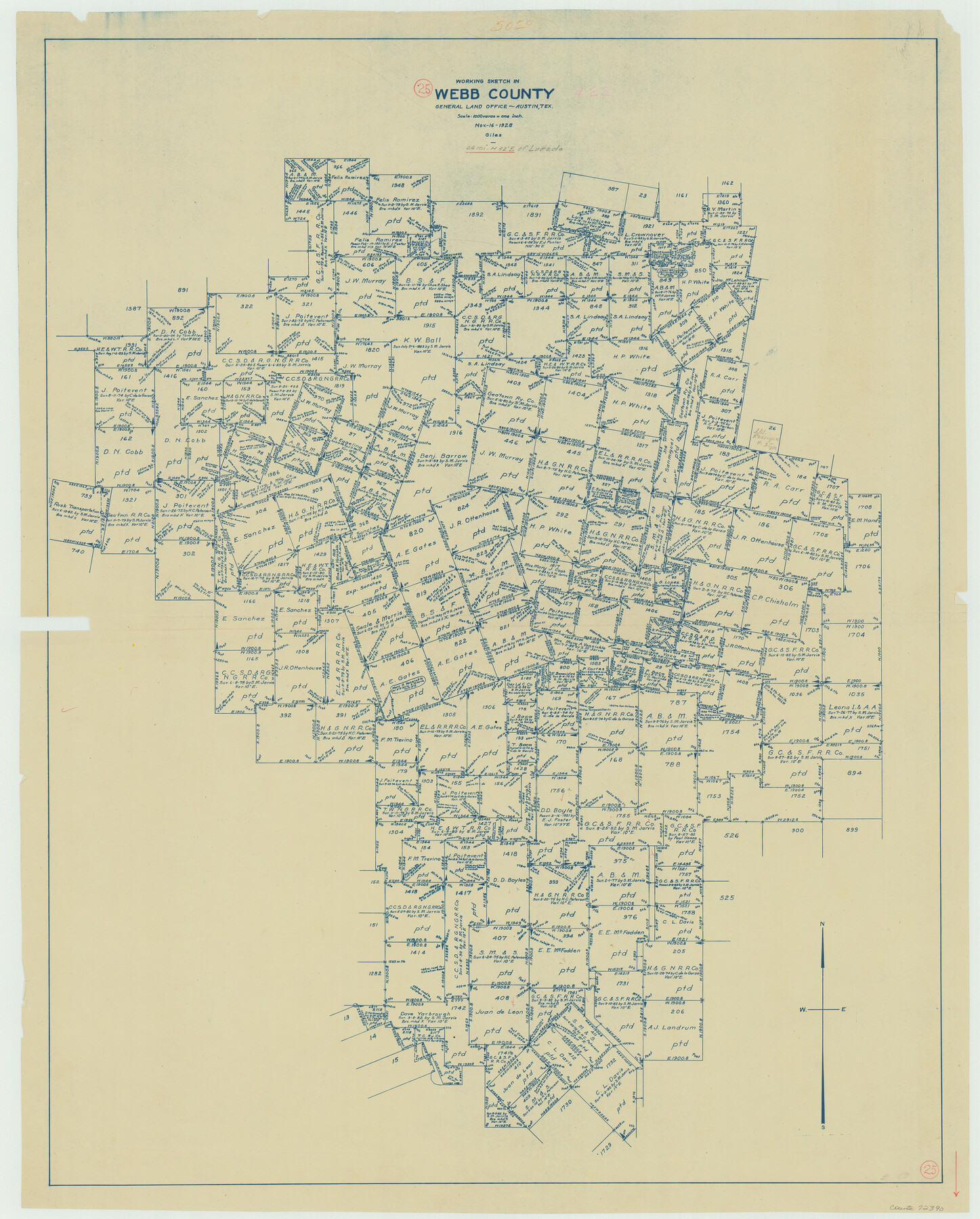
Webb County Working Sketch 25
-
Map/Doc
72390
-
Collection
General Map Collection
-
Object Dates
11/16/1928 (Creation Date)
-
People and Organizations
J. Bascom Giles (Draftsman)
-
Counties
Webb
-
Subjects
Surveying Working Sketch
-
Height x Width
38.8 x 31.2 inches
98.6 x 79.3 cm
-
Scale
1" = 1000 varas
Part of: General Map Collection
Howard County Sketch File 5

Print $3.00
- Digital $50.00
Howard County Sketch File 5
Size 20.0 x 12.8 inches
Map/Doc 11794
Flight Mission No. DQN-1K, Frame 49, Calhoun County

Print $20.00
- Digital $50.00
Flight Mission No. DQN-1K, Frame 49, Calhoun County
1953
Size 18.6 x 22.4 inches
Map/Doc 84149
Uvalde County Working Sketch 2

Print $20.00
- Digital $50.00
Uvalde County Working Sketch 2
1911
Size 23.3 x 21.3 inches
Map/Doc 72072
Clay County Sketch File 37

Print $8.00
- Digital $50.00
Clay County Sketch File 37
1935
Size 11.6 x 7.2 inches
Map/Doc 18465
Refugio County Sketch File 17a

Print $2.00
- Digital $50.00
Refugio County Sketch File 17a
1916
Size 11.4 x 9.0 inches
Map/Doc 35275
Medina County Working Sketch 21

Print $20.00
- Digital $50.00
Medina County Working Sketch 21
1982
Size 18.1 x 23.3 inches
Map/Doc 70936
Concho County Working Sketch 19

Print $20.00
- Digital $50.00
Concho County Working Sketch 19
1957
Size 27.3 x 24.9 inches
Map/Doc 68201
Houston County Sketch File 32

Print $4.00
- Digital $50.00
Houston County Sketch File 32
1877
Size 10.8 x 7.1 inches
Map/Doc 26809
Mapa Original de Texas por El Ciudadano Estevan F. Austin Presentado al Exmo. Sr. Presidente por su autor 1829

Print $20.00
- Digital $50.00
Mapa Original de Texas por El Ciudadano Estevan F. Austin Presentado al Exmo. Sr. Presidente por su autor 1829
1830
Size 32.3 x 25.3 inches
Map/Doc 2106
Henderson County Rolled Sketch 11

Print $20.00
- Digital $50.00
Henderson County Rolled Sketch 11
1915
Size 29.4 x 42.5 inches
Map/Doc 75946
Right of Way and Track Map, the Missouri, Kansas and Texas Ry. of Texas - Henrietta Division

Print $20.00
- Digital $50.00
Right of Way and Track Map, the Missouri, Kansas and Texas Ry. of Texas - Henrietta Division
1918
Size 11.8 x 26.9 inches
Map/Doc 64748
Sabine Pass and Lake

Print $40.00
- Digital $50.00
Sabine Pass and Lake
1992
Size 49.2 x 28.6 inches
Map/Doc 69828
You may also like
Calhoun County NRC Article 33.136 Location Key Sheet

Print $20.00
- Digital $50.00
Calhoun County NRC Article 33.136 Location Key Sheet
1995
Size 27.0 x 22.0 inches
Map/Doc 77011
Garza County Rolled Sketch P

Print $20.00
- Digital $50.00
Garza County Rolled Sketch P
1914
Size 21.3 x 23.3 inches
Map/Doc 6005

Crockett County Working Sketch 101

Print $20.00
- Digital $50.00
Crockett County Working Sketch 101
Size 16.3 x 20.3 inches
Map/Doc 67436

[Texas Department of Corrections Prison Farm Locations]
![78638, [Texas Department of Corrections Prison Farm Locations], General Map Collection](https://historictexasmaps.com/wmedia_w700/maps/78638.tif.jpg)
Print $40.00
- Digital $50.00
[Texas Department of Corrections Prison Farm Locations]
Size 43.0 x 54.0 inches
Map/Doc 78638
Flight Mission No. CRK-3P, Frame 132, Refugio County

Print $20.00
- Digital $50.00
Flight Mission No. CRK-3P, Frame 132, Refugio County
1956
Size 18.6 x 22.6 inches
Map/Doc 86920
Brewster County Rolled Sketch K

Print $20.00
- Digital $50.00
Brewster County Rolled Sketch K
1884
Size 19.6 x 13.9 inches
Map/Doc 5321
Red River Co.

Print $20.00
- Digital $50.00
Red River Co.
1897
Size 46.7 x 36.9 inches
Map/Doc 78402

Brazos Santiago, Texas

Print $20.00
- Digital $50.00
Brazos Santiago, Texas
1900
Size 18.3 x 26.9 inches
Map/Doc 73031
Texas State Boundary Line 9

Print $174.00
Texas State Boundary Line 9
2000
Size 11.3 x 8.8 inches
Map/Doc 75076