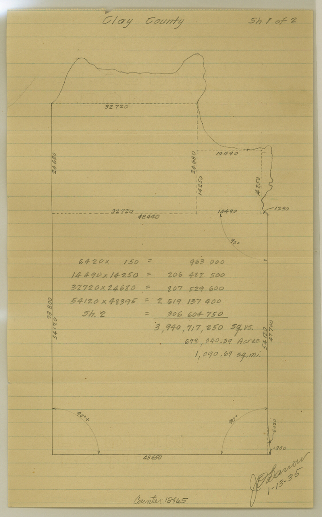
Clay County Sketch File 37
[Calculations of area of Clay County]
-
Map/Doc
18465
-
Collection
General Map Collection
-
Object Dates
1935/1/13 (File Date)
1935/1/13 (Creation Date)
-
People and Organizations
J.O. Barrow (Surveyor/Engineer)
-
Counties
Clay
-
Subjects
Surveying Sketch File
-
Height x Width
11.6 x 7.2 inches
29.5 x 18.3 cm
-
Medium
paper, manuscript
Part of: General Map Collection
Texas, Matagorda Bay, Port O'Connor to Gallinipper Point

Print $40.00
- Digital $50.00
Texas, Matagorda Bay, Port O'Connor to Gallinipper Point
1933
Size 31.1 x 48.6 inches
Map/Doc 69985
Childress County

Print $20.00
- Digital $50.00
Childress County
1892
Size 24.7 x 19.6 inches
Map/Doc 3391
Engineer's Office, Department of the Gulf Map No. 59, Texas prepared by order of Maj. Gen. N. P. Banks under direction of Capt. P. C. Hains, U. S. Engr. & Chief Engr., Dept. of the Gulf

Print $20.00
- Digital $50.00
Engineer's Office, Department of the Gulf Map No. 59, Texas prepared by order of Maj. Gen. N. P. Banks under direction of Capt. P. C. Hains, U. S. Engr. & Chief Engr., Dept. of the Gulf
1865
Size 18.2 x 27.5 inches
Map/Doc 72718
Knox County Sketch File 9

Print $4.00
- Digital $50.00
Knox County Sketch File 9
1889
Size 11.1 x 8.8 inches
Map/Doc 29221
Flight Mission No. DIX-10P, Frame 176, Aransas County

Print $20.00
- Digital $50.00
Flight Mission No. DIX-10P, Frame 176, Aransas County
1956
Size 18.6 x 22.3 inches
Map/Doc 83966
Crosby County Sketch File 5

Print $10.00
- Digital $50.00
Crosby County Sketch File 5
1887
Size 9.2 x 7.8 inches
Map/Doc 20002
Kent County Working Sketch 23

Print $20.00
- Digital $50.00
Kent County Working Sketch 23
1987
Size 47.2 x 43.0 inches
Map/Doc 70030
Ector County Rolled Sketch 11

Print $20.00
- Digital $50.00
Ector County Rolled Sketch 11
1947
Size 47.5 x 38.8 inches
Map/Doc 8839
Padre Island Under Six Flags

Print $40.00
- Digital $50.00
Padre Island Under Six Flags
1962
Size 63.7 x 36.9 inches
Map/Doc 3126

Gaines County Sketch File 8

Print $40.00
- Digital $50.00
Gaines County Sketch File 8
1941
Size 14.2 x 17.2 inches
Map/Doc 23191
DeWitt County Working Sketch 1

Print $20.00
- Digital $50.00
DeWitt County Working Sketch 1
1937
Size 24.2 x 30.8 inches
Map/Doc 68591
You may also like
Trinity County Sketch File 13

Print $6.00
- Digital $50.00
Trinity County Sketch File 13
1857
Size 5.0 x 6.3 inches
Map/Doc 38537
Wood County Sketch File 9

Print $4.00
- Digital $50.00
Wood County Sketch File 9
1852
Size 7.4 x 8.9 inches
Map/Doc 40656
Flight Mission No. DCL-7C, Frame 137, Kenedy County

Print $20.00
- Digital $50.00
Flight Mission No. DCL-7C, Frame 137, Kenedy County
1943
Size 15.4 x 15.3 inches
Map/Doc 86094
Cameron County Rolled Sketch 7

Print $20.00
- Digital $50.00
Cameron County Rolled Sketch 7
1926
Size 27.4 x 31.8 inches
Map/Doc 8563
Bosque County Working Sketch 12

Print $20.00
- Digital $50.00
Bosque County Working Sketch 12
1957
Size 18.3 x 21.8 inches
Map/Doc 67445
Freestone County Sketch File 9

Print $4.00
- Digital $50.00
Freestone County Sketch File 9
1859
Size 7.9 x 8.3 inches
Map/Doc 23056
Rusk County Working Sketch 8

Print $20.00
- Digital $50.00
Rusk County Working Sketch 8
1981
Size 22.4 x 20.6 inches
Map/Doc 63643
Dickens County Sketch File 18a

Print $20.00
- Digital $50.00
Dickens County Sketch File 18a
Size 17.6 x 19.4 inches
Map/Doc 11322
Montgomery County Working Sketch 8a

Print $20.00
- Digital $50.00
Montgomery County Working Sketch 8a
1932
Size 17.8 x 20.4 inches
Map/Doc 71114
[Map of Navarro County]
![81900, [Map of Navarro County], General Map Collection](https://historictexasmaps.com/wmedia_w700/maps/81900.tif.jpg)
Print $20.00
- Digital $50.00
[Map of Navarro County]
1858
Size 18.0 x 23.5 inches
Map/Doc 81900
General Highway Map, Clay County, Texas

Print $20.00
General Highway Map, Clay County, Texas
1961
Size 24.8 x 18.2 inches
Map/Doc 79409
Webb County Sketch File 19

Print $15.00
- Digital $50.00
Webb County Sketch File 19
1902
Size 9.2 x 17.0 inches
Map/Doc 39822