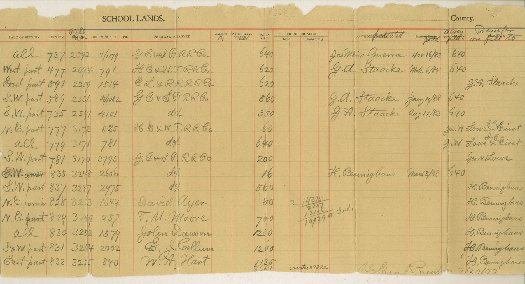
Webb County Sketch File 19
[List of individual surveys at the northeast end of the large Borego grant in the south part of the county]
-
Map/Doc
39822
-
Collection
General Map Collection
-
Object Dates
7/30/1902 (Creation Date)
-
Counties
Webb
-
Subjects
Surveying Sketch File
-
Height x Width
9.2 x 17.0 inches
23.4 x 43.2 cm
-
Medium
paper, manuscript
Part of: General Map Collection
W. Alvin Lloyd's Southern Rail-Road Map

Print $20.00
- Digital $50.00
W. Alvin Lloyd's Southern Rail-Road Map
1863
Size 18.4 x 23.7 inches
Map/Doc 97496
Harrison County Rolled Sketch 14

Print $20.00
- Digital $50.00
Harrison County Rolled Sketch 14
1968
Size 25.8 x 20.0 inches
Map/Doc 6157
Leon County Working Sketch 52b

Print $20.00
- Digital $50.00
Leon County Working Sketch 52b
1982
Size 33.6 x 33.5 inches
Map/Doc 70452
Howard County Sketch File 10

Print $20.00
- Digital $50.00
Howard County Sketch File 10
Size 22.5 x 22.0 inches
Map/Doc 11798
Culberson County Working Sketch 90

Print $20.00
- Digital $50.00
Culberson County Working Sketch 90
1992
Size 35.0 x 28.0 inches
Map/Doc 68544
Coke County Rolled Sketch 20

Print $20.00
- Digital $50.00
Coke County Rolled Sketch 20
1954
Size 16.0 x 30.5 inches
Map/Doc 5521
Lampasas County Sketch File 16

Print $20.00
- Digital $50.00
Lampasas County Sketch File 16
1893
Size 22.8 x 20.8 inches
Map/Doc 11976
Shelby County Rolled Sketch 3

Print $40.00
- Digital $50.00
Shelby County Rolled Sketch 3
Size 54.2 x 37.0 inches
Map/Doc 9919
Flight Mission No. DIX-8P, Frame 86, Aransas County

Print $20.00
- Digital $50.00
Flight Mission No. DIX-8P, Frame 86, Aransas County
1956
Size 18.4 x 22.3 inches
Map/Doc 83911
Brewster County Rolled Sketch 22C

Print $20.00
- Digital $50.00
Brewster County Rolled Sketch 22C
1910
Size 23.7 x 18.8 inches
Map/Doc 5204
Calhoun County Boundary File 14

Print $58.00
- Digital $50.00
Calhoun County Boundary File 14
Size 11.2 x 8.8 inches
Map/Doc 51014
Travis County Working Sketch 7

Print $2.00
- Digital $50.00
Travis County Working Sketch 7
1913
Size 10.9 x 8.2 inches
Map/Doc 69391
You may also like
Hudspeth County Rolled Sketch 36

Print $20.00
- Digital $50.00
Hudspeth County Rolled Sketch 36
1952
Size 30.8 x 19.9 inches
Map/Doc 6249
Andrews County Rolled Sketch 19

Print $20.00
- Digital $50.00
Andrews County Rolled Sketch 19
1945
Size 23.3 x 28.1 inches
Map/Doc 77167
General Highway Map, Nolan County, Texas

Print $20.00
General Highway Map, Nolan County, Texas
1940
Size 18.4 x 24.7 inches
Map/Doc 79208
Trinity River, East Fork of Trinity River Levee Improvement Districts/Widths of Floodways as Established by Approved Plans

Print $4.00
- Digital $50.00
Trinity River, East Fork of Trinity River Levee Improvement Districts/Widths of Floodways as Established by Approved Plans
1919
Size 28.4 x 18.5 inches
Map/Doc 65248
Right of Way & Track Map, St. Louis, Brownsville & Mexico Ry. operated by St. Louis, Brownsville & Mexico Ry. Co.

Print $40.00
- Digital $50.00
Right of Way & Track Map, St. Louis, Brownsville & Mexico Ry. operated by St. Louis, Brownsville & Mexico Ry. Co.
1919
Size 25.7 x 57.1 inches
Map/Doc 64625
Capitol Lands Surveyed by J. T. Munson

Print $20.00
- Digital $50.00
Capitol Lands Surveyed by J. T. Munson
Size 22.0 x 19.5 inches
Map/Doc 90604
Flight Mission No. CRK-5P, Frame 161, Refugio County

Print $20.00
- Digital $50.00
Flight Mission No. CRK-5P, Frame 161, Refugio County
1956
Size 18.5 x 22.4 inches
Map/Doc 86942
Comanche County Working Sketch 20

Print $20.00
- Digital $50.00
Comanche County Working Sketch 20
1973
Size 20.5 x 15.6 inches
Map/Doc 68154
Johnson County Sketch File 8

Print $6.00
- Digital $50.00
Johnson County Sketch File 8
1859
Size 8.0 x 9.7 inches
Map/Doc 28440
[Leagues 218- 236]
![91454, [Leagues 218- 236], Twichell Survey Records](https://historictexasmaps.com/wmedia_w700/maps/91454-1.tif.jpg)
Print $2.00
- Digital $50.00
[Leagues 218- 236]
Size 7.0 x 11.6 inches
Map/Doc 91454
The Chief Justice County of Jasper. Lands in Conflict with Sabine County

Print $20.00
The Chief Justice County of Jasper. Lands in Conflict with Sabine County
2020
Size 18.3 x 21.7 inches
Map/Doc 96053
Anderson County Sketch File 13

Print $10.00
- Digital $50.00
Anderson County Sketch File 13
1856
Size 8.1 x 8.3 inches
Map/Doc 12774