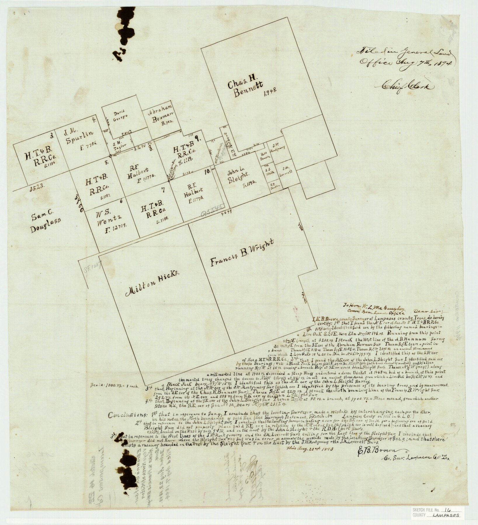
Lampasas County Sketch File 16
[Sketch of Milton Hicks & Francis B. Wright surveys and area to the north in the north part of Lampasas County]
-
Map/Doc
11976
-
Collection
General Map Collection
-
Object Dates
8/23/1893 (Creation Date)
8/7/1894 (File Date)
-
People and Organizations
E.B. Brown (Surveyor/Engineer)
-
Counties
Lampasas
-
Subjects
Surveying Sketch File
-
Height x Width
22.8 x 20.8 inches
57.9 x 52.8 cm
-
Medium
paper, manuscript
-
Scale
1" = 1000 varas
Part of: General Map Collection
Lynn County Working Sketch Graphic Index

Print $20.00
- Digital $50.00
Lynn County Working Sketch Graphic Index
1961
Size 38.7 x 35.1 inches
Map/Doc 76627
Flight Mission No. CRC-2R, Frame 197, Chambers County

Print $20.00
- Digital $50.00
Flight Mission No. CRC-2R, Frame 197, Chambers County
1956
Size 18.7 x 22.5 inches
Map/Doc 84775
Flight Mission No. CUG-1P, Frame 168, Kleberg County

Print $20.00
- Digital $50.00
Flight Mission No. CUG-1P, Frame 168, Kleberg County
1956
Size 18.6 x 22.2 inches
Map/Doc 86175
Jasper County Rolled Sketch 7B

Print $20.00
- Digital $50.00
Jasper County Rolled Sketch 7B
Size 19.7 x 11.6 inches
Map/Doc 6355
Sketch of a portion of the Texas Coast showing the relative positions of different harbours with the interior Military Posts, and the roads communicating with them, also two new routes from Black Point and Lamar to San Antonio

Print $20.00
- Digital $50.00
Sketch of a portion of the Texas Coast showing the relative positions of different harbours with the interior Military Posts, and the roads communicating with them, also two new routes from Black Point and Lamar to San Antonio
1855
Size 27.5 x 18.2 inches
Map/Doc 72708
Clay County Sketch File 18

Print $4.00
- Digital $50.00
Clay County Sketch File 18
1875
Size 12.6 x 8.4 inches
Map/Doc 18427
Flight Mission No. CRK-7P, Frame 131, Refugio County

Print $20.00
- Digital $50.00
Flight Mission No. CRK-7P, Frame 131, Refugio County
1956
Size 18.3 x 22.1 inches
Map/Doc 86954
Zapata County Rolled Sketch 10A

Print $20.00
- Digital $50.00
Zapata County Rolled Sketch 10A
1912
Size 26.3 x 26.5 inches
Map/Doc 8312
Franklin County Sketch File 16

Print $6.00
- Digital $50.00
Franklin County Sketch File 16
Size 13.2 x 8.2 inches
Map/Doc 23023
El Paso County State Real Property Sketch 4

Print $20.00
- Digital $50.00
El Paso County State Real Property Sketch 4
2012
Size 29.9 x 35.9 inches
Map/Doc 93701
Flight Mission No. BQR-9K, Frame 48, Brazoria County

Print $20.00
- Digital $50.00
Flight Mission No. BQR-9K, Frame 48, Brazoria County
1952
Size 18.7 x 22.2 inches
Map/Doc 84052
Presidio County Working Sketch 121a

Print $20.00
- Digital $50.00
Presidio County Working Sketch 121a
Size 34.2 x 38.0 inches
Map/Doc 71798
You may also like
Gaines County Sketch File 2M

Print $20.00
- Digital $50.00
Gaines County Sketch File 2M
1902
Size 20.8 x 29.4 inches
Map/Doc 11522
Shelby County Working Sketch 36

Print $20.00
- Digital $50.00
Shelby County Working Sketch 36
2011
Size 35.0 x 36.0 inches
Map/Doc 90093
Jones County Sketch File 21

Print $56.00
- Digital $50.00
Jones County Sketch File 21
2010
Map/Doc 93292
[Surveys in Austin's Colony along the San Bernardo River from the mouth of Peach Creek]
![209, [Surveys in Austin's Colony along the San Bernardo River from the mouth of Peach Creek], General Map Collection](https://historictexasmaps.com/wmedia_w700/maps/209.tif.jpg)
Print $20.00
- Digital $50.00
[Surveys in Austin's Colony along the San Bernardo River from the mouth of Peach Creek]
1821
Size 23.4 x 10.6 inches
Map/Doc 209
Tyler County Sketch File 21

Print $4.00
- Digital $50.00
Tyler County Sketch File 21
1906
Size 10.9 x 9.1 inches
Map/Doc 38677
Palo Pinto County Working Sketch 11

Print $20.00
- Digital $50.00
Palo Pinto County Working Sketch 11
1942
Size 21.2 x 22.1 inches
Map/Doc 71394
Flight Mission No. BQR-9K, Frame 11, Brazoria County

Print $20.00
- Digital $50.00
Flight Mission No. BQR-9K, Frame 11, Brazoria County
1952
Size 18.7 x 22.4 inches
Map/Doc 84040
[Portions of Hansford and Hutchinson Counties]
![91136, [Portions of Hansford and Hutchinson Counties], Twichell Survey Records](https://historictexasmaps.com/wmedia_w700/maps/91136-1.tif.jpg)
Print $3.00
- Digital $50.00
[Portions of Hansford and Hutchinson Counties]
Size 11.5 x 13.5 inches
Map/Doc 91136
Reeves County Sketch File 26

Print $4.00
- Digital $50.00
Reeves County Sketch File 26
1964
Size 4.1 x 8.8 inches
Map/Doc 35226
Sketch of the Northwest Portion of Hutchinson County

Print $20.00
- Digital $50.00
Sketch of the Northwest Portion of Hutchinson County
Size 19.8 x 13.6 inches
Map/Doc 91139
Flight Mission No. DQN-3K, Frame 34, Calhoun County

Print $20.00
- Digital $50.00
Flight Mission No. DQN-3K, Frame 34, Calhoun County
1953
Size 18.8 x 22.3 inches
Map/Doc 84347
Township 1 South Range 12 West, South Western District, Louisiana

Print $20.00
- Digital $50.00
Township 1 South Range 12 West, South Western District, Louisiana
1884
Size 19.5 x 24.7 inches
Map/Doc 65880