[Surveys along the Colorado River]
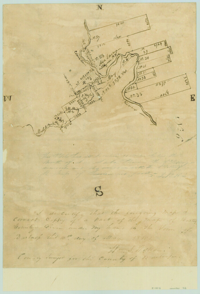
Print $2.00
- Digital $50.00
[Surveys along the Colorado River]
1841
Size: 12.2 x 8.3 inches
112
[Surveys in the Travis District along the Colorado River]
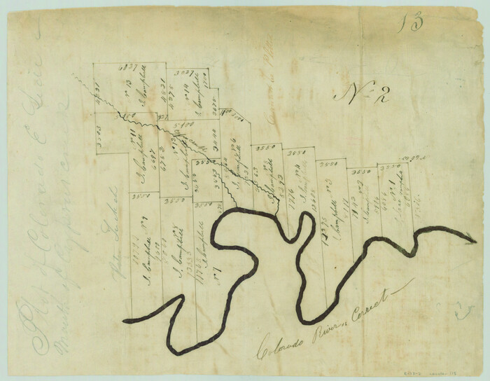
Print $2.00
- Digital $50.00
[Surveys in the Travis District along the Colorado River]
1840
Size: 8.0 x 10.2 inches
115
Hamilton County Sketch File 16

Print $20.00
- Digital $50.00
Hamilton County Sketch File 16
1898
Size: 22.6 x 19.6 inches
11616
[Surveys in the Travis District along the Colorado River]
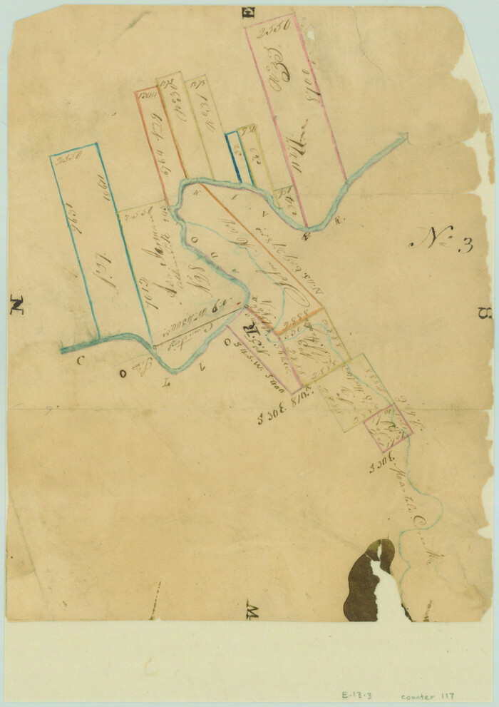
Print $2.00
- Digital $50.00
[Surveys in the Travis District along the Colorado River]
1840
Size: 8.9 x 6.3 inches
117
Lampasas County Sketch File 15

Print $20.00
- Digital $50.00
Lampasas County Sketch File 15
1888
Size: 24.5 x 27.1 inches
11975
Lampasas County Sketch File 16

Print $20.00
- Digital $50.00
Lampasas County Sketch File 16
1893
Size: 22.8 x 20.8 inches
11976
Lampasas County Sketch File B

Print $20.00
- Digital $50.00
Lampasas County Sketch File B
1886
Size: 15.0 x 22.4 inches
11977
Burnet County Sketch File 14a

Print $6.00
- Digital $50.00
Burnet County Sketch File 14a
Size: 17.0 x 11.0 inches
16700
Burnet County Sketch File 27a

Print $10.00
- Digital $50.00
Burnet County Sketch File 27a
1876
Size: 8.7 x 8.2 inches
16732
Burnet County Sketch File 27b

Print $7.00
- Digital $50.00
Burnet County Sketch File 27b
1876
Size: 10.3 x 8.1 inches
16737
Lampasas River, City of Lampasas, Lampasas Sheet/Sulphur & Burleson Creeks

Print $20.00
- Digital $50.00
Lampasas River, City of Lampasas, Lampasas Sheet/Sulphur & Burleson Creeks
1937
Size: 33.4 x 19.3 inches
16956
[Sketch from Burnet Co. to Baylor Co. tying center of counties to county site]
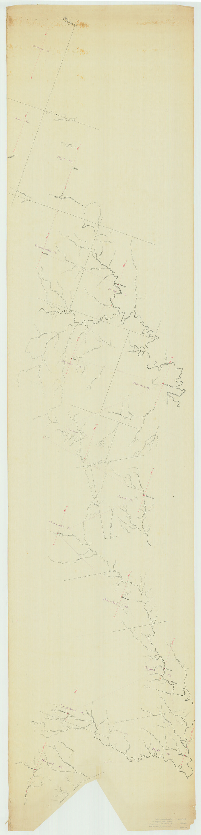
Print $40.00
- Digital $50.00
[Sketch from Burnet Co. to Baylor Co. tying center of counties to county site]
1900
Size: 132.6 x 31.9 inches
1699
Coryell County Sketch File 16

Print $4.00
- Digital $50.00
Coryell County Sketch File 16
Size: 6.5 x 5.4 inches
19373
Hamilton County Sketch File 6

Print $6.00
- Digital $50.00
Hamilton County Sketch File 6
Size: 15.7 x 10.6 inches
24910
Hamilton County Sketch File 10 1/2

Print $44.00
- Digital $50.00
Hamilton County Sketch File 10 1/2
1876
Size: 9.2 x 8.3 inches
24931
Hamilton County Sketch File 15

Print $2.00
- Digital $50.00
Hamilton County Sketch File 15
1882
Size: 8.0 x 11.8 inches
24941
Lampasas County Sketch File A

Print $4.00
- Digital $50.00
Lampasas County Sketch File A
1887
Size: 11.3 x 9.0 inches
29383
Lampasas County Sketch File A1

Print $2.00
- Digital $50.00
Lampasas County Sketch File A1
Size: 6.8 x 6.3 inches
29385
Lampasas County Sketch File X

Print $40.00
- Digital $50.00
Lampasas County Sketch File X
1909
Size: 13.2 x 17.4 inches
29386
Lampasas County Sketch File 1

Print $4.00
- Digital $50.00
Lampasas County Sketch File 1
Size: 12.6 x 8.1 inches
29388
Lampasas County Sketch File 2

Print $40.00
- Digital $50.00
Lampasas County Sketch File 2
1858
Size: 15.6 x 12.7 inches
29390
Lampasas County Sketch File 3

Print $4.00
- Digital $50.00
Lampasas County Sketch File 3
1856
Size: 12.1 x 7.6 inches
29392
Lampasas County Sketch File 4

Print $4.00
- Digital $50.00
Lampasas County Sketch File 4
1861
Size: 12.3 x 8.2 inches
29394
Lampasas County Sketch File 5

Print $8.00
- Digital $50.00
Lampasas County Sketch File 5
1869
Size: 12.8 x 7.9 inches
29396
Lampasas County Sketch File 6

Print $4.00
- Digital $50.00
Lampasas County Sketch File 6
1871
Size: 8.0 x 6.8 inches
29400
Lampasas County Sketch File 7

Print $4.00
- Digital $50.00
Lampasas County Sketch File 7
1871
Size: 8.4 x 8.2 inches
29402
Lampasas County Sketch File 7a

Print $4.00
- Digital $50.00
Lampasas County Sketch File 7a
1854
Size: 12.4 x 8.2 inches
29404
Lampasas County Sketch File 8

Print $4.00
- Digital $50.00
Lampasas County Sketch File 8
1872
Size: 8.8 x 7.7 inches
29406
Lampasas County Sketch File 9

Print $4.00
- Digital $50.00
Lampasas County Sketch File 9
1873
Size: 9.4 x 7.3 inches
29408
[Surveys along the Colorado River]
Print $2.00
- Digital $50.00
[Surveys along the Colorado River]
1841
-
Size
12.2 x 8.3 inches
-
Map/Doc
112
-
Creation Date
1841
[Surveys in the Travis District along the Colorado River]
Print $2.00
- Digital $50.00
[Surveys in the Travis District along the Colorado River]
1840
-
Size
8.0 x 10.2 inches
-
Map/Doc
115
-
Creation Date
1840
Hamilton County Sketch File 16
Print $20.00
- Digital $50.00
Hamilton County Sketch File 16
1898
-
Size
22.6 x 19.6 inches
-
Map/Doc
11616
-
Creation Date
1898
[Surveys in the Travis District along the Colorado River]
Print $2.00
- Digital $50.00
[Surveys in the Travis District along the Colorado River]
1840
-
Size
8.9 x 6.3 inches
-
Map/Doc
117
-
Creation Date
1840
Lampasas County Sketch File 15
Print $20.00
- Digital $50.00
Lampasas County Sketch File 15
1888
-
Size
24.5 x 27.1 inches
-
Map/Doc
11975
-
Creation Date
1888
Lampasas County Sketch File 16
Print $20.00
- Digital $50.00
Lampasas County Sketch File 16
1893
-
Size
22.8 x 20.8 inches
-
Map/Doc
11976
-
Creation Date
1893
Lampasas County Sketch File B
Print $20.00
- Digital $50.00
Lampasas County Sketch File B
1886
-
Size
15.0 x 22.4 inches
-
Map/Doc
11977
-
Creation Date
1886
Burnet County Sketch File 14a
Print $6.00
- Digital $50.00
Burnet County Sketch File 14a
-
Size
17.0 x 11.0 inches
-
Map/Doc
16700
Burnet County Sketch File 27a
Print $10.00
- Digital $50.00
Burnet County Sketch File 27a
1876
-
Size
8.7 x 8.2 inches
-
Map/Doc
16732
-
Creation Date
1876
Burnet County Sketch File 27b
Print $7.00
- Digital $50.00
Burnet County Sketch File 27b
1876
-
Size
10.3 x 8.1 inches
-
Map/Doc
16737
-
Creation Date
1876
Lampasas Co.

Print $20.00
- Digital $50.00
Lampasas Co.
1888
-
Size
31.0 x 40.5 inches
-
Map/Doc
16874
-
Creation Date
1888
Lampasas River, City of Lampasas, Lampasas Sheet/Sulphur & Burleson Creeks
Print $20.00
- Digital $50.00
Lampasas River, City of Lampasas, Lampasas Sheet/Sulphur & Burleson Creeks
1937
-
Size
33.4 x 19.3 inches
-
Map/Doc
16956
-
Creation Date
1937
[Sketch from Burnet Co. to Baylor Co. tying center of counties to county site]
Print $40.00
- Digital $50.00
[Sketch from Burnet Co. to Baylor Co. tying center of counties to county site]
1900
-
Size
132.6 x 31.9 inches
-
Map/Doc
1699
-
Creation Date
1900
Coryell County Sketch File 16
Print $4.00
- Digital $50.00
Coryell County Sketch File 16
-
Size
6.5 x 5.4 inches
-
Map/Doc
19373
Hamilton County Sketch File 6
Print $6.00
- Digital $50.00
Hamilton County Sketch File 6
-
Size
15.7 x 10.6 inches
-
Map/Doc
24910
Hamilton County Sketch File 10 1/2
Print $44.00
- Digital $50.00
Hamilton County Sketch File 10 1/2
1876
-
Size
9.2 x 8.3 inches
-
Map/Doc
24931
-
Creation Date
1876
Hamilton County Sketch File 15
Print $2.00
- Digital $50.00
Hamilton County Sketch File 15
1882
-
Size
8.0 x 11.8 inches
-
Map/Doc
24941
-
Creation Date
1882
Lampasas County Sketch File A
Print $4.00
- Digital $50.00
Lampasas County Sketch File A
1887
-
Size
11.3 x 9.0 inches
-
Map/Doc
29383
-
Creation Date
1887
Lampasas County Sketch File A1
Print $2.00
- Digital $50.00
Lampasas County Sketch File A1
-
Size
6.8 x 6.3 inches
-
Map/Doc
29385
Lampasas County Sketch File X
Print $40.00
- Digital $50.00
Lampasas County Sketch File X
1909
-
Size
13.2 x 17.4 inches
-
Map/Doc
29386
-
Creation Date
1909
Lampasas County Sketch File 1
Print $4.00
- Digital $50.00
Lampasas County Sketch File 1
-
Size
12.6 x 8.1 inches
-
Map/Doc
29388
Lampasas County Sketch File 2
Print $40.00
- Digital $50.00
Lampasas County Sketch File 2
1858
-
Size
15.6 x 12.7 inches
-
Map/Doc
29390
-
Creation Date
1858
Lampasas County Sketch File 3
Print $4.00
- Digital $50.00
Lampasas County Sketch File 3
1856
-
Size
12.1 x 7.6 inches
-
Map/Doc
29392
-
Creation Date
1856
Lampasas County Sketch File 4
Print $4.00
- Digital $50.00
Lampasas County Sketch File 4
1861
-
Size
12.3 x 8.2 inches
-
Map/Doc
29394
-
Creation Date
1861
Lampasas County Sketch File 5
Print $8.00
- Digital $50.00
Lampasas County Sketch File 5
1869
-
Size
12.8 x 7.9 inches
-
Map/Doc
29396
-
Creation Date
1869
Lampasas County Sketch File 6
Print $4.00
- Digital $50.00
Lampasas County Sketch File 6
1871
-
Size
8.0 x 6.8 inches
-
Map/Doc
29400
-
Creation Date
1871
Lampasas County Sketch File 7
Print $4.00
- Digital $50.00
Lampasas County Sketch File 7
1871
-
Size
8.4 x 8.2 inches
-
Map/Doc
29402
-
Creation Date
1871
Lampasas County Sketch File 7a
Print $4.00
- Digital $50.00
Lampasas County Sketch File 7a
1854
-
Size
12.4 x 8.2 inches
-
Map/Doc
29404
-
Creation Date
1854
Lampasas County Sketch File 8
Print $4.00
- Digital $50.00
Lampasas County Sketch File 8
1872
-
Size
8.8 x 7.7 inches
-
Map/Doc
29406
-
Creation Date
1872
Lampasas County Sketch File 9
Print $4.00
- Digital $50.00
Lampasas County Sketch File 9
1873
-
Size
9.4 x 7.3 inches
-
Map/Doc
29408
-
Creation Date
1873