[Travis District]
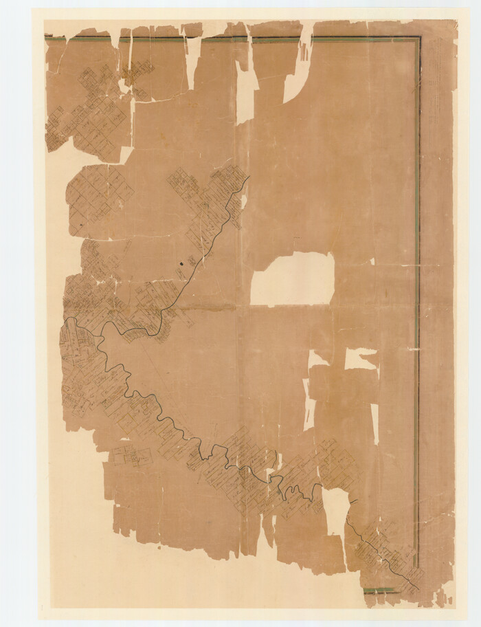
Print $40.00
- Digital $50.00
[Travis District]
1840
Size: 54.7 x 42.0 inches
88739
[Travis District]
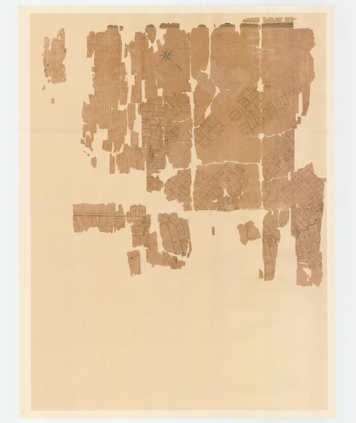
Print $40.00
- Digital $50.00
[Travis District]
1840
Size: 54.7 x 46.0 inches
88740
[Surveys in the Travis District along the Colorado River]
Print $2.00
- Digital $50.00
[Surveys in the Travis District along the Colorado River]
1840
Size: 8.0 x 10.2 inches
115
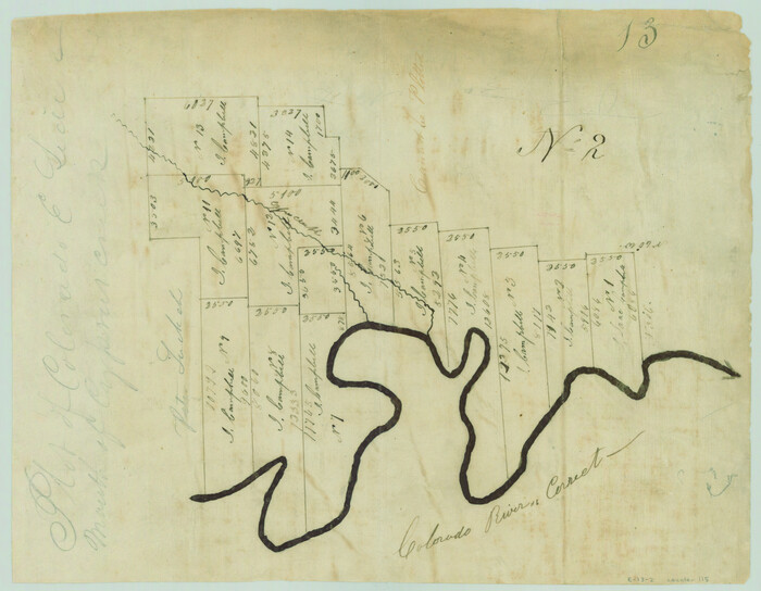
[Surveys in the Travis District along the Colorado River]
Print $2.00
- Digital $50.00
[Surveys in the Travis District along the Colorado River]
1840
Size: 8.9 x 6.3 inches
117
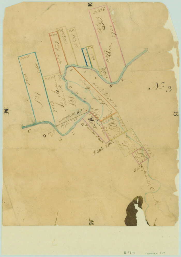
[Surveys along the Colorado River]
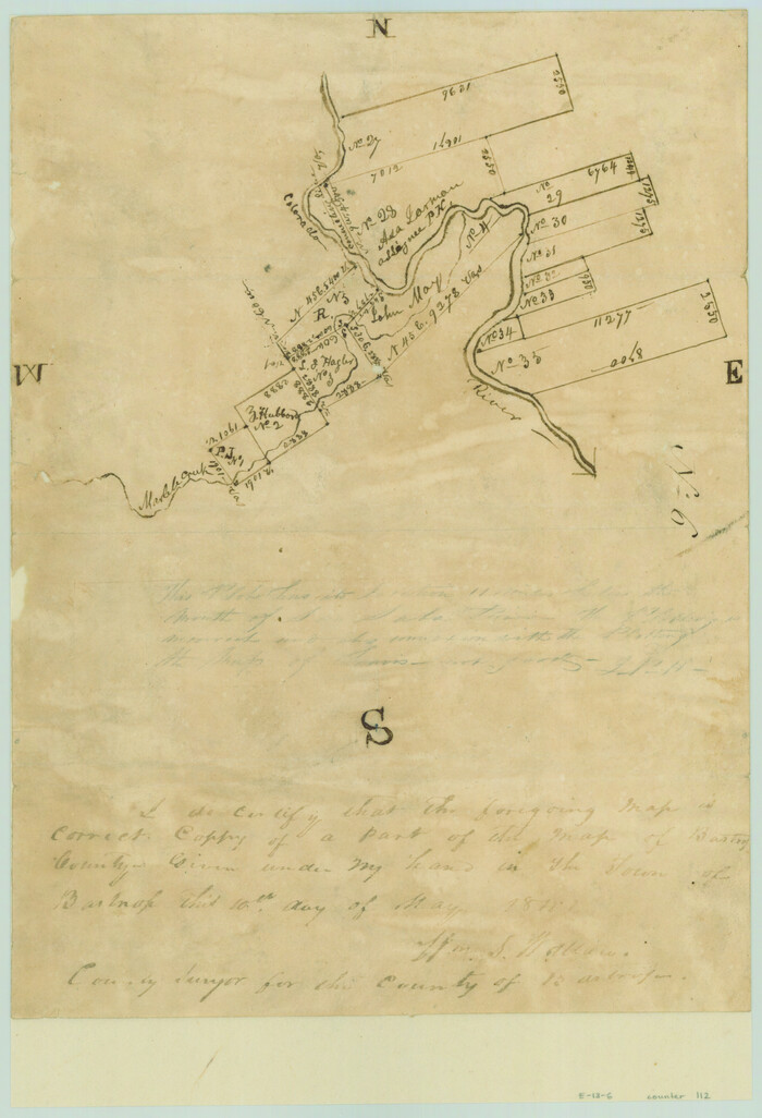
Print $2.00
- Digital $50.00
[Surveys along the Colorado River]
1841
Size: 12.2 x 8.3 inches
112
[Sketch from Burnet Co. to Baylor Co. tying center of counties to county site]
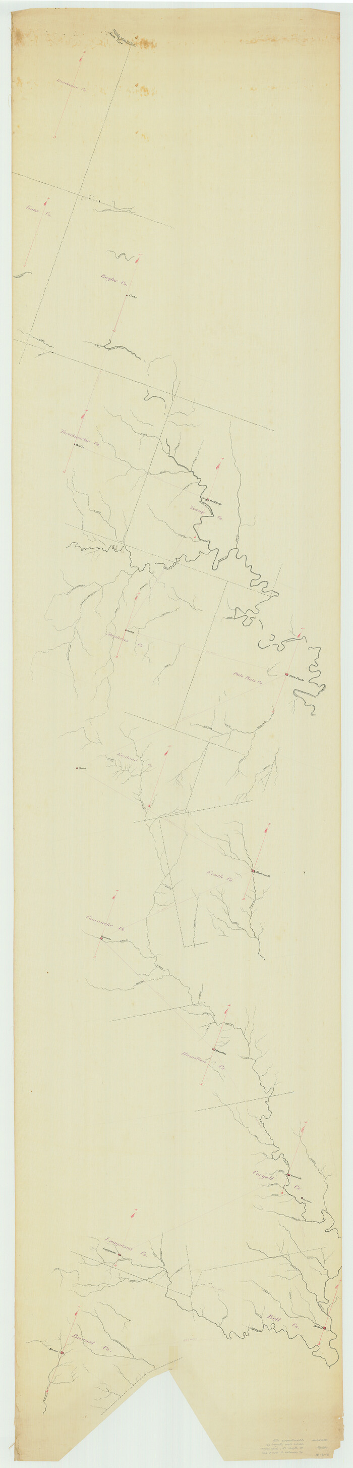
Print $40.00
- Digital $50.00
[Sketch from Burnet Co. to Baylor Co. tying center of counties to county site]
1900
Size: 132.6 x 31.9 inches
1699
Water-Shed of the Colorado River

Print $40.00
- Digital $50.00
Water-Shed of the Colorado River
1925
Size: 37.1 x 79.8 inches
65261
Mills County Working Sketch 9

Print $20.00
- Digital $50.00
Mills County Working Sketch 9
1915
Size: 13.3 x 13.7 inches
71039
Mills County Working Sketch 28

Print $40.00
- Digital $50.00
Mills County Working Sketch 28
2006
Size: 42.0 x 67.4 inches
85385
Mills County Sketch File 6

Print $4.00
- Digital $50.00
Mills County Sketch File 6
Size: 9.0 x 9.8 inches
31655
Mills County Sketch File 11

Print $6.00
- Digital $50.00
Mills County Sketch File 11
1876
Size: 10.6 x 13.0 inches
31659
Map of San Gabriel & Lampassas [sic] Surveys
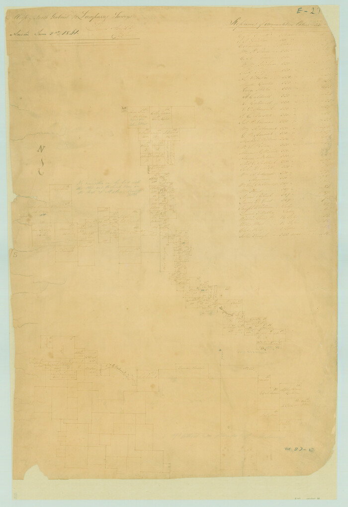
Print $20.00
- Digital $50.00
Map of San Gabriel & Lampassas [sic] Surveys
1841
Size: 29.0 x 20.0 inches
58
Map of Lampasas County, Texas

Print $20.00
- Digital $50.00
Map of Lampasas County, Texas
1879
Size: 23.4 x 28.4 inches
560
Map of Lampasas County

Print $20.00
- Digital $50.00
Map of Lampasas County
1856
Size: 19.7 x 25.3 inches
3792
Map of Lampasas County

Print $20.00
- Digital $50.00
Map of Lampasas County
1864
Size: 20.5 x 24.8 inches
3793
Map of Lampasas County

Print $20.00
- Digital $50.00
Map of Lampasas County
1876
Size: 18.7 x 24.4 inches
3794
Map of Lampasas County

Print $40.00
- Digital $50.00
Map of Lampasas County
1900
Size: 47.1 x 60.2 inches
62971
Map of Lampasas Co.

Print $20.00
- Digital $50.00
Map of Lampasas Co.
1888
Size: 34.4 x 42.4 inches
5080
Map of City of Lampasas, Texas

Print $20.00
- Digital $50.00
Map of City of Lampasas, Texas
1935
Size: 26.1 x 17.6 inches
4827
Lampasas River, City of Lampasas, Lampasas Sheet/Sulphur & Burleson Creeks

Print $20.00
- Digital $50.00
Lampasas River, City of Lampasas, Lampasas Sheet/Sulphur & Burleson Creeks
1937
Size: 33.4 x 19.3 inches
16956
Lampasas County Working Sketch Graphic Index

Print $20.00
- Digital $50.00
Lampasas County Working Sketch Graphic Index
1972
Size: 34.6 x 42.0 inches
76614
Lampasas County Working Sketch 9

Print $40.00
- Digital $50.00
Lampasas County Working Sketch 9
1963
Size: 32.9 x 56.3 inches
70286
Lampasas County Working Sketch 8

Print $20.00
- Digital $50.00
Lampasas County Working Sketch 8
1958
Size: 36.4 x 37.1 inches
70285
Lampasas County Working Sketch 7

Print $20.00
- Digital $50.00
Lampasas County Working Sketch 7
1951
Size: 30.7 x 36.3 inches
70284
Lampasas County Working Sketch 6

Print $20.00
- Digital $50.00
Lampasas County Working Sketch 6
1950
Size: 29.5 x 20.6 inches
70283
Lampasas County Working Sketch 5

Print $20.00
- Digital $50.00
Lampasas County Working Sketch 5
1947
Size: 25.6 x 31.8 inches
70282
Lampasas County Working Sketch 4

Print $20.00
- Digital $50.00
Lampasas County Working Sketch 4
1941
Size: 23.1 x 16.8 inches
70281
Lampasas County Working Sketch 3

Print $20.00
- Digital $50.00
Lampasas County Working Sketch 3
1941
Size: 25.0 x 14.6 inches
70280
[Travis District]
Print $40.00
- Digital $50.00
[Travis District]
1840
-
Size
54.7 x 42.0 inches
-
Map/Doc
88739
-
Creation Date
1840
[Travis District]
Print $40.00
- Digital $50.00
[Travis District]
1840
-
Size
54.7 x 46.0 inches
-
Map/Doc
88740
-
Creation Date
1840
[Surveys in the Travis District along the Colorado River]
Print $2.00
- Digital $50.00
[Surveys in the Travis District along the Colorado River]
1840
-
Size
8.0 x 10.2 inches
-
Map/Doc
115
-
Creation Date
1840
[Surveys in the Travis District along the Colorado River]
Print $2.00
- Digital $50.00
[Surveys in the Travis District along the Colorado River]
1840
-
Size
8.9 x 6.3 inches
-
Map/Doc
117
-
Creation Date
1840
[Surveys along the Colorado River]
Print $2.00
- Digital $50.00
[Surveys along the Colorado River]
1841
-
Size
12.2 x 8.3 inches
-
Map/Doc
112
-
Creation Date
1841
[Sketch from Burnet Co. to Baylor Co. tying center of counties to county site]
Print $40.00
- Digital $50.00
[Sketch from Burnet Co. to Baylor Co. tying center of counties to county site]
1900
-
Size
132.6 x 31.9 inches
-
Map/Doc
1699
-
Creation Date
1900
Water-Shed of the Colorado River
Print $40.00
- Digital $50.00
Water-Shed of the Colorado River
1925
-
Size
37.1 x 79.8 inches
-
Map/Doc
65261
-
Creation Date
1925
Texas Hill Country Trail Region

Texas Hill Country Trail Region
2017
-
Size
18.2 x 24.3 inches
-
Map/Doc
96871
-
Creation Date
2017
Texas Hill Country Trail Region

Texas Hill Country Trail Region
-
Size
18.1 x 24.2 inches
-
Map/Doc
96872
Mills County Working Sketch 9
Print $20.00
- Digital $50.00
Mills County Working Sketch 9
1915
-
Size
13.3 x 13.7 inches
-
Map/Doc
71039
-
Creation Date
1915
Mills County Working Sketch 28
Print $40.00
- Digital $50.00
Mills County Working Sketch 28
2006
-
Size
42.0 x 67.4 inches
-
Map/Doc
85385
-
Creation Date
2006
Mills County Sketch File 6
Print $4.00
- Digital $50.00
Mills County Sketch File 6
-
Size
9.0 x 9.8 inches
-
Map/Doc
31655
Mills County Sketch File 11
Print $6.00
- Digital $50.00
Mills County Sketch File 11
1876
-
Size
10.6 x 13.0 inches
-
Map/Doc
31659
-
Creation Date
1876
Map of San Gabriel & Lampassas [sic] Surveys
Print $20.00
- Digital $50.00
Map of San Gabriel & Lampassas [sic] Surveys
1841
-
Size
29.0 x 20.0 inches
-
Map/Doc
58
-
Creation Date
1841
Map of Lampasas County, Texas
Print $20.00
- Digital $50.00
Map of Lampasas County, Texas
1879
-
Size
23.4 x 28.4 inches
-
Map/Doc
560
-
Creation Date
1879
Map of Lampasas County
Print $20.00
- Digital $50.00
Map of Lampasas County
1856
-
Size
19.7 x 25.3 inches
-
Map/Doc
3792
-
Creation Date
1856
Map of Lampasas County
Print $20.00
- Digital $50.00
Map of Lampasas County
1864
-
Size
20.5 x 24.8 inches
-
Map/Doc
3793
-
Creation Date
1864
Map of Lampasas County
Print $20.00
- Digital $50.00
Map of Lampasas County
1876
-
Size
18.7 x 24.4 inches
-
Map/Doc
3794
-
Creation Date
1876
Map of Lampasas County
Print $40.00
- Digital $50.00
Map of Lampasas County
1900
-
Size
47.1 x 60.2 inches
-
Map/Doc
62971
-
Creation Date
1900
Map of Lampasas Co.
Print $20.00
- Digital $50.00
Map of Lampasas Co.
1888
-
Size
34.4 x 42.4 inches
-
Map/Doc
5080
-
Creation Date
1888
Map of City of Lampasas, Texas
Print $20.00
- Digital $50.00
Map of City of Lampasas, Texas
1935
-
Size
26.1 x 17.6 inches
-
Map/Doc
4827
-
Creation Date
1935
Lampasas River, City of Lampasas, Lampasas Sheet/Sulphur & Burleson Creeks
Print $20.00
- Digital $50.00
Lampasas River, City of Lampasas, Lampasas Sheet/Sulphur & Burleson Creeks
1937
-
Size
33.4 x 19.3 inches
-
Map/Doc
16956
-
Creation Date
1937
Lampasas County Working Sketch Graphic Index
Print $20.00
- Digital $50.00
Lampasas County Working Sketch Graphic Index
1972
-
Size
34.6 x 42.0 inches
-
Map/Doc
76614
-
Creation Date
1972
Lampasas County Working Sketch 9
Print $40.00
- Digital $50.00
Lampasas County Working Sketch 9
1963
-
Size
32.9 x 56.3 inches
-
Map/Doc
70286
-
Creation Date
1963
Lampasas County Working Sketch 8
Print $20.00
- Digital $50.00
Lampasas County Working Sketch 8
1958
-
Size
36.4 x 37.1 inches
-
Map/Doc
70285
-
Creation Date
1958
Lampasas County Working Sketch 7
Print $20.00
- Digital $50.00
Lampasas County Working Sketch 7
1951
-
Size
30.7 x 36.3 inches
-
Map/Doc
70284
-
Creation Date
1951
Lampasas County Working Sketch 6
Print $20.00
- Digital $50.00
Lampasas County Working Sketch 6
1950
-
Size
29.5 x 20.6 inches
-
Map/Doc
70283
-
Creation Date
1950
Lampasas County Working Sketch 5
Print $20.00
- Digital $50.00
Lampasas County Working Sketch 5
1947
-
Size
25.6 x 31.8 inches
-
Map/Doc
70282
-
Creation Date
1947
Lampasas County Working Sketch 4
Print $20.00
- Digital $50.00
Lampasas County Working Sketch 4
1941
-
Size
23.1 x 16.8 inches
-
Map/Doc
70281
-
Creation Date
1941
Lampasas County Working Sketch 3
Print $20.00
- Digital $50.00
Lampasas County Working Sketch 3
1941
-
Size
25.0 x 14.6 inches
-
Map/Doc
70280
-
Creation Date
1941