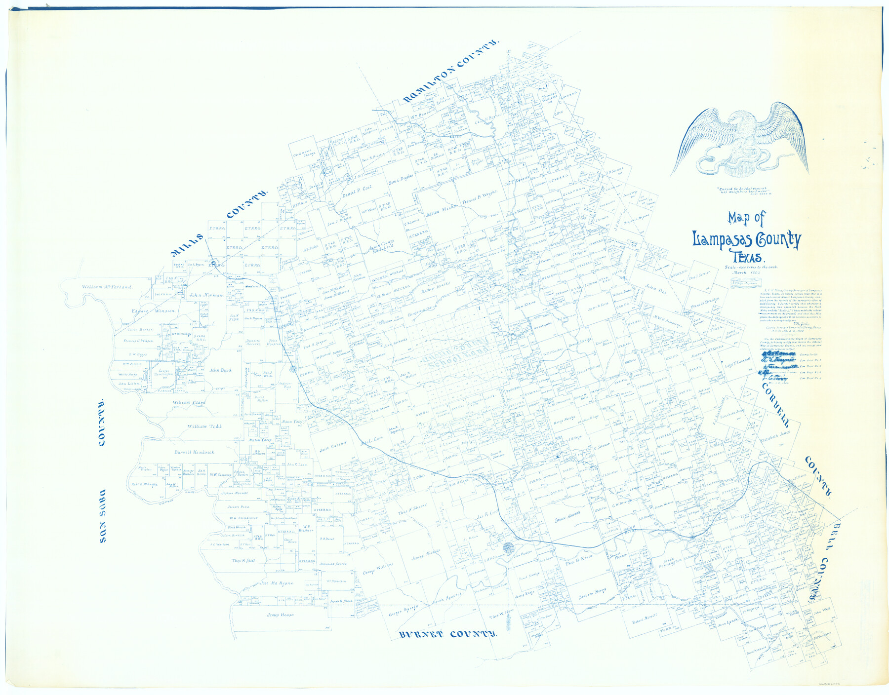
Map of Lampasas County
-
Map/Doc
62971
-
Collection
General Map Collection
-
Object Dates
1900 (Creation Date)
-
People and Organizations
Lampasas County (Publisher)
V.N. Zivley (Compiler)
V.N. Zivley (Draftsman)
V.N. Zivley (Surveyor/Engineer)
-
Counties
Lampasas
-
Subjects
County
-
Height x Width
47.1 x 60.2 inches
119.6 x 152.9 cm
-
Comments
Gift of Jerry Goodson.
For information only. -
Features
Donaldson Creek
Fall Creek
Lucy's Creek
Salt Creek
GC&SF
South Lucys Creek
Copperas Cove
Lynchs Creek
Colorado River
Hughs Branch [of Donaldson Creek]
Lometa
Izora
Kempner
Sulphur Fork [of Lampasas River]
Lampasas
Yancy Creek
Mesquite Creek
Burnt Branch [of Lampasas River]
Rocky Creek
Stavely Branch [of Lampasas River]
Dunn Branch of [Lampasas River]
Bennetts Creek
Turkey Creek
Atherton
South Sims' Creek
Antelope Gap
Elliots Creek
Boggy Branch [of Sims Creek]
Kinchelow Branch [of Sims Creek]
Lampasas River
Edgar Branch [of Sims Creek]
Sims' Creek
[ ]ck Branch [of Lampasas River]
Bear Branch [of Lampasas River]
Patterson Creek
Antelope Creek
Cottenwood [sic] Creek
Emerys Creek
Part of: General Map Collection
Flight Mission No. DQO-3K, Frame 38, Galveston County

Print $20.00
- Digital $50.00
Flight Mission No. DQO-3K, Frame 38, Galveston County
1952
Size 18.7 x 22.3 inches
Map/Doc 85079
Hutchinson County Working Sketch 29

Print $20.00
- Digital $50.00
Hutchinson County Working Sketch 29
1978
Size 26.5 x 22.1 inches
Map/Doc 66389
El Paso County Working Sketch 8

Print $20.00
- Digital $50.00
El Paso County Working Sketch 8
1952
Size 23.9 x 22.5 inches
Map/Doc 69030
Sutton County Working Sketch 51

Print $20.00
- Digital $50.00
Sutton County Working Sketch 51
1955
Size 12.1 x 27.7 inches
Map/Doc 62394
Frio County Working Sketch 15

Print $20.00
- Digital $50.00
Frio County Working Sketch 15
1961
Size 31.2 x 43.5 inches
Map/Doc 69289
Williamson County Working Sketch 15

Print $20.00
- Digital $50.00
Williamson County Working Sketch 15
1982
Size 22.3 x 28.4 inches
Map/Doc 72575
Flight Mission No. DQO-7K, Frame 99, Galveston County

Print $20.00
- Digital $50.00
Flight Mission No. DQO-7K, Frame 99, Galveston County
1952
Size 18.7 x 22.5 inches
Map/Doc 85114
Presidio County Working Sketch 84

Print $20.00
- Digital $50.00
Presidio County Working Sketch 84
1970
Size 20.7 x 17.8 inches
Map/Doc 71761
Bandera County Sketch File 6

Print $4.00
- Digital $50.00
Bandera County Sketch File 6
1877
Size 8.0 x 12.7 inches
Map/Doc 14005
Map of the Central States to illustrate Olney's school geography

Print $20.00
- Digital $50.00
Map of the Central States to illustrate Olney's school geography
1844
Size 12.1 x 19.0 inches
Map/Doc 93539
Wichita County

Print $20.00
- Digital $50.00
Wichita County
1924
Size 32.1 x 39.1 inches
Map/Doc 16924
Pecos County Rolled Sketch 127

Print $20.00
- Digital $50.00
Pecos County Rolled Sketch 127
Size 20.7 x 23.9 inches
Map/Doc 7267
You may also like
Lee County Working Sketch 13

Print $20.00
- Digital $50.00
Lee County Working Sketch 13
1981
Size 33.4 x 35.7 inches
Map/Doc 70392
Harrison County Working Sketch 15

Print $20.00
- Digital $50.00
Harrison County Working Sketch 15
1961
Size 25.7 x 18.0 inches
Map/Doc 66035
Fractional Township No. 8 South Range No. 21 East of the Indian Meridian, Indian Territory

Print $20.00
- Digital $50.00
Fractional Township No. 8 South Range No. 21 East of the Indian Meridian, Indian Territory
1897
Size 19.2 x 24.2 inches
Map/Doc 75238
Travis County Sketch File 65

Print $4.00
- Digital $50.00
Travis County Sketch File 65
1948
Size 9.1 x 9.1 inches
Map/Doc 38438
Bailey County Sketch File B

Print $40.00
- Digital $50.00
Bailey County Sketch File B
Size 14.5 x 20.4 inches
Map/Doc 10891
Parker County Sketch File 49

Print $6.00
- Digital $50.00
Parker County Sketch File 49
Size 10.6 x 8.8 inches
Map/Doc 33618
[Sketch for Mineral Application 16700 - Pecos River Bed]
![2807, [Sketch for Mineral Application 16700 - Pecos River Bed], General Map Collection](https://historictexasmaps.com/wmedia_w700/maps/2807.tif.jpg)
Print $20.00
- Digital $50.00
[Sketch for Mineral Application 16700 - Pecos River Bed]
1927
Size 32.9 x 15.3 inches
Map/Doc 2807
Cherokee County Working Sketch 14

Print $40.00
- Digital $50.00
Cherokee County Working Sketch 14
1957
Size 44.9 x 61.1 inches
Map/Doc 67969
Zapata County Rolled Sketch 19

Print $20.00
- Digital $50.00
Zapata County Rolled Sketch 19
1955
Size 29.0 x 20.9 inches
Map/Doc 8316
Terrell County Sketch File 18

Print $8.00
- Digital $50.00
Terrell County Sketch File 18
1908
Size 9.1 x 4.4 inches
Map/Doc 37941
Erath County Working Sketch 22

Print $20.00
- Digital $50.00
Erath County Working Sketch 22
1965
Size 29.8 x 36.8 inches
Map/Doc 69103
Wilson County Working Sketch 3

Print $20.00
- Digital $50.00
Wilson County Working Sketch 3
1952
Size 33.6 x 33.2 inches
Map/Doc 72583