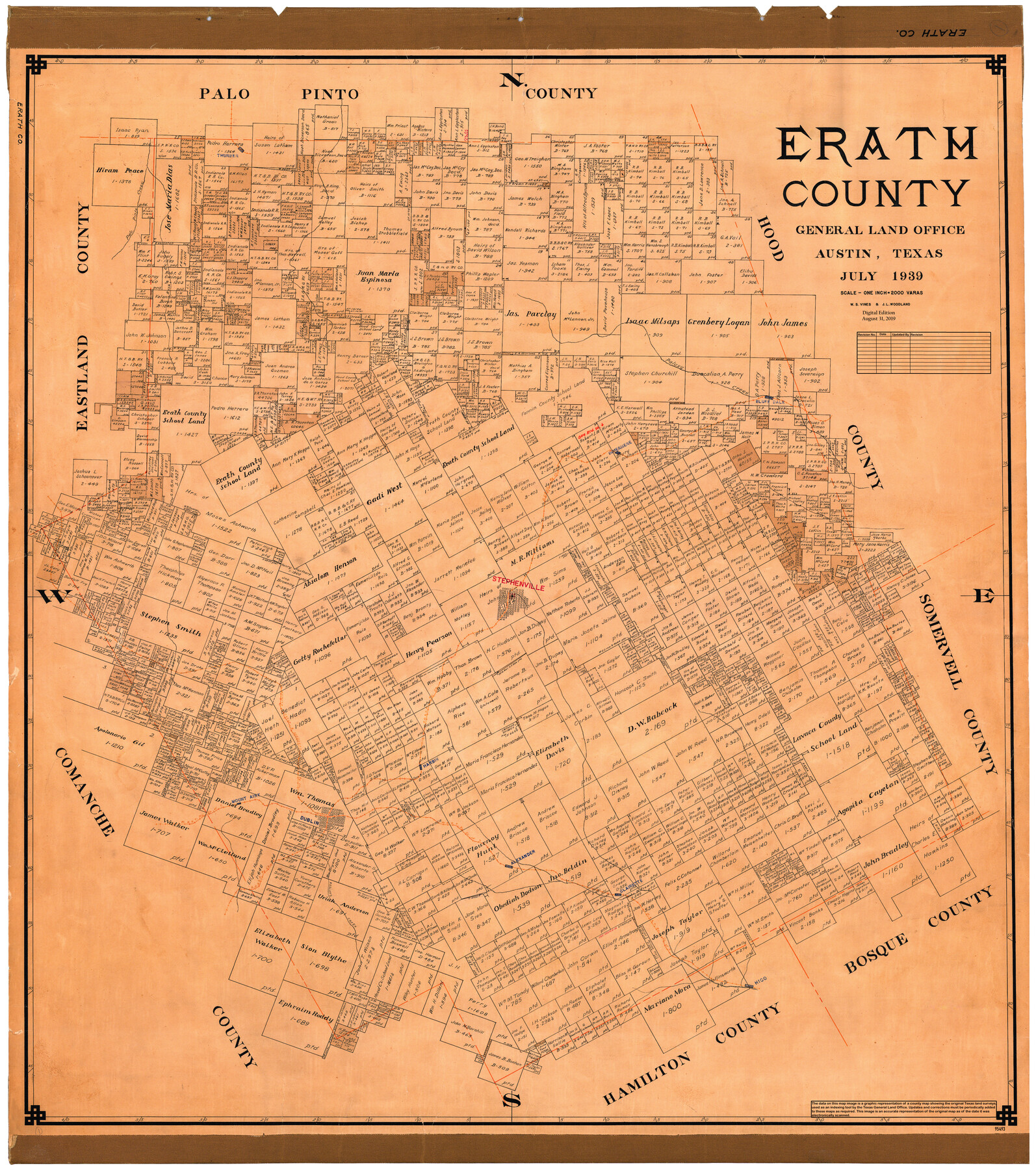
Erath County
General Land Office Official County Map
-
Map/Doc
95493
-
Collection
General Map Collection
-
Object Dates
1939 (Creation Date)
2019/8/31 (Revision Date)
-
People and Organizations
W.S. Vines (Draftsman)
J.L. Woodland (Draftsman)
Cheyenne Betancourt (Draftsman)
-
Counties
Erath
-
Subjects
County OCM
-
Height x Width
49.5 x 43.9 inches
125.7 x 111.5 cm
-
Medium
digital image
-
Scale
1" = 2000 varas
Part of: General Map Collection
Harris County Working Sketch 114

Print $20.00
- Digital $50.00
Harris County Working Sketch 114
1983
Size 37.6 x 29.0 inches
Map/Doc 66006
La Salle County Sketch File 30

Print $22.00
- Digital $50.00
La Salle County Sketch File 30
1880
Size 12.6 x 8.2 inches
Map/Doc 29565
Runnels County

Print $20.00
- Digital $50.00
Runnels County
1933
Size 43.7 x 31.1 inches
Map/Doc 16801
Ward County Sketch File 5

Print $5.00
- Digital $50.00
Ward County Sketch File 5
1873
Size 11.0 x 17.0 inches
Map/Doc 39619
Callahan County Sketch File 9

Print $40.00
- Digital $50.00
Callahan County Sketch File 9
1880
Size 16.8 x 14.3 inches
Map/Doc 35871
Llano County Working Sketch 1

Print $20.00
- Digital $50.00
Llano County Working Sketch 1
1938
Size 19.5 x 19.2 inches
Map/Doc 70619
El Paso County

Print $40.00
- Digital $50.00
El Paso County
1881
Size 51.5 x 15.7 inches
Map/Doc 89057
Freestone County Sketch File 25

Print $18.00
- Digital $50.00
Freestone County Sketch File 25
1952
Size 11.3 x 8.6 inches
Map/Doc 23087
Flight Mission No. CRK-5P, Frame 163, Refugio County

Print $20.00
- Digital $50.00
Flight Mission No. CRK-5P, Frame 163, Refugio County
1956
Size 18.4 x 22.2 inches
Map/Doc 86944
Fannin County Rolled Sketch 22

Print $20.00
- Digital $50.00
Fannin County Rolled Sketch 22
Size 19.1 x 20.7 inches
Map/Doc 5875
Edwards County Working Sketch 74

Print $20.00
- Digital $50.00
Edwards County Working Sketch 74
1959
Size 23.6 x 38.4 inches
Map/Doc 68950
Callahan County Working Sketch 14

Print $20.00
- Digital $50.00
Callahan County Working Sketch 14
2010
Size 25.8 x 23.7 inches
Map/Doc 89273
You may also like
Pecos County Rolled Sketch 157

Print $233.00
- Digital $50.00
Pecos County Rolled Sketch 157
1962
Size 10.5 x 15.3 inches
Map/Doc 48558
Val Verde County Sketch File 11

Print $8.00
- Digital $50.00
Val Verde County Sketch File 11
1972
Size 11.3 x 8.9 inches
Map/Doc 39110
Gillespie County Working Sketch Graphic Index

Print $20.00
- Digital $50.00
Gillespie County Working Sketch Graphic Index
1945
Size 38.0 x 47.4 inches
Map/Doc 76553
Glasscock County Working Sketch 8

Print $20.00
- Digital $50.00
Glasscock County Working Sketch 8
Size 42.7 x 10.3 inches
Map/Doc 62189
Galveston County Rolled Sketch 31

Print $20.00
- Digital $50.00
Galveston County Rolled Sketch 31
1979
Size 28.4 x 39.8 inches
Map/Doc 5965
Intracoastal Waterway - Gibbstown to Port Arthur

Print $20.00
- Digital $50.00
Intracoastal Waterway - Gibbstown to Port Arthur
1961
Size 26.6 x 38.7 inches
Map/Doc 69833
Supreme Court of the United States, October Term, 1924, No. 13, Original - The State of Oklahoma, Complainant vs. The State of Texas, Defendant, The United States, Intervener

Print $20.00
- Digital $50.00
Supreme Court of the United States, October Term, 1924, No. 13, Original - The State of Oklahoma, Complainant vs. The State of Texas, Defendant, The United States, Intervener
1924
Size 26.5 x 38.5 inches
Map/Doc 75131
San Patricio County Rolled Sketch 50

Print $29.00
- Digital $50.00
San Patricio County Rolled Sketch 50
1988
Size 18.2 x 23.5 inches
Map/Doc 7736
Kimble County Sketch File A1

Print $4.00
- Digital $50.00
Kimble County Sketch File A1
Size 8.8 x 13.4 inches
Map/Doc 28961
Map of the Missouri Pacific Central Branch U.P.R.R. St. Louis, Iron Mountain & Southern International & Great Northern and Texas and Pacific Railways

Print $20.00
- Digital $50.00
Map of the Missouri Pacific Central Branch U.P.R.R. St. Louis, Iron Mountain & Southern International & Great Northern and Texas and Pacific Railways
1890
Size 28.7 x 24.4 inches
Map/Doc 97505
Outer Continental Shelf Leasing Maps (Texas Offshore Operations)

Print $20.00
- Digital $50.00
Outer Continental Shelf Leasing Maps (Texas Offshore Operations)
Size 29.9 x 21.7 inches
Map/Doc 75857
Hemphill County Working Sketch 37

Print $20.00
- Digital $50.00
Hemphill County Working Sketch 37
1981
Size 28.6 x 24.0 inches
Map/Doc 66132