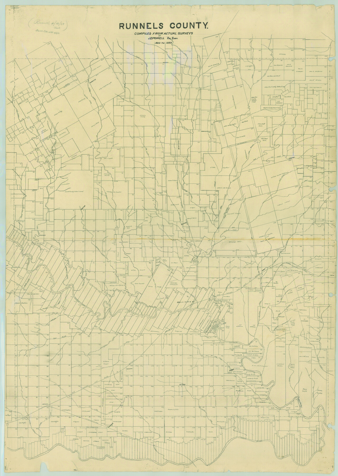
Runnels County
-
Map/Doc
16801
-
Collection
General Map Collection
-
Object Dates
1933/4/16 (Creation Date)
-
People and Organizations
Runnels County (Publisher)
J.E. Powell (Compiler)
J.E. Powell (Surveyor/Engineer)
-
Counties
Runnels
-
Subjects
County
-
Height x Width
43.7 x 31.1 inches
111.0 x 79.0 cm
-
Comments
Compiled 1903 to 1933.
"Received in office April 18, 1933".
Help Save Texas History - Adopt Me! -
Features
Olfen
Willow Creek
Bottle Creek
Lowake
Concho River
Dead Man Bluff
Brushy Bluff
Fuzzy Creek
Little Concho River
Spring Creek
Long Branch [of Elm Creek]
Rocky Creek
Grape Creek
Pony
Buffalo Bluff
Pony Creek
Red Bank Creek
Indian Creek
Rowena
CCSS&LV
Talpa
Marie
Mule Creek
Miles
Maverick
Norton
Wingate
Stony Creek
Drasco
Winters
Hatchel
Ballinger
Benoit
Crews
Tokeen
Valley Creek
Mud Creek
Flat Creek
Antelope Creek
Mustang Creek
Gap Creek
Long Branch [of Colorado River]
Little Coyote Creek
Dry Hollow Creek
Eagle Branch of Elm Creek
Oak Creek
Wagon Tire Creek
Sheep Hollow Creek
Elm Creek
Pecan Springs Branch [of Mustang Creek]
Bluff Creek
Salt Branch of Bluff Creek
Butternut Creek
Sand Branch of Colorado River
Spur Creek
Cow Creek
Rough Hollow Creek
Colorado River
Wire Hollow Creek
Live Oak Creek
GC&SF
Coyote Creek
Los Arroyo
Bull Hollow Creek
Mesquite Creek
Juniper Creek
Quarry Creek
Hog Creek
A&S
Part of: General Map Collection
Ward County Rolled Sketch 24F

Print $40.00
- Digital $50.00
Ward County Rolled Sketch 24F
Size 30.5 x 65.2 inches
Map/Doc 78232
Flight Mission No. CRC-3R, Frame 211, Chambers County

Print $20.00
- Digital $50.00
Flight Mission No. CRC-3R, Frame 211, Chambers County
1956
Size 18.6 x 22.2 inches
Map/Doc 84866
Falls County Sketch File 33

Print $4.00
- Digital $50.00
Falls County Sketch File 33
1873
Size 10.3 x 8.3 inches
Map/Doc 22441
Hays County Boundary File 1

Print $14.00
- Digital $50.00
Hays County Boundary File 1
Size 9.5 x 5.2 inches
Map/Doc 54586
Val Verde County Working Sketch 32

Print $20.00
- Digital $50.00
Val Verde County Working Sketch 32
1938
Size 41.5 x 24.2 inches
Map/Doc 72167

Guadalupe County Working Sketch 4

Print $20.00
- Digital $50.00
Guadalupe County Working Sketch 4
1939
Size 17.7 x 10.8 inches
Map/Doc 63313
Ward County Working Sketch 14

Print $20.00
- Digital $50.00
Ward County Working Sketch 14
1947
Size 30.3 x 28.8 inches
Map/Doc 72320
Map of Starr County

Print $20.00
- Digital $50.00
Map of Starr County
1896
Size 43.7 x 26.9 inches
Map/Doc 4050
Walker County Working Sketch 17

Print $20.00
- Digital $50.00
Walker County Working Sketch 17
1982
Size 19.9 x 20.8 inches
Map/Doc 72297
Tyler County Sketch File A

Print $5.00
- Digital $50.00
Tyler County Sketch File A
1849
Size 9.9 x 15.1 inches
Map/Doc 38603
Jeff Davis County Texas

Print $20.00
- Digital $50.00
Jeff Davis County Texas
Size 15.9 x 21.3 inches
Map/Doc 4573
You may also like
Stephens County Working Sketch 8

Print $20.00
- Digital $50.00
Stephens County Working Sketch 8
1920
Size 21.0 x 28.7 inches
Map/Doc 63951
Map of Texas and Pacific Ry. Company's Surveys in the 80 Mile Reserve

Print $40.00
- Digital $50.00
Map of Texas and Pacific Ry. Company's Surveys in the 80 Mile Reserve
1885
Size 44.0 x 51.6 inches
Map/Doc 83557
Duval County Rolled Sketch DCR

Print $40.00
- Digital $50.00
Duval County Rolled Sketch DCR
1931
Size 41.8 x 93.5 inches
Map/Doc 8804
Houston County Sketch File 38

Print $8.00
- Digital $50.00
Houston County Sketch File 38
Size 12.8 x 8.3 inches
Map/Doc 26821
Harrison County Sketch File 6

Print $4.00
- Digital $50.00
Harrison County Sketch File 6
Size 12.9 x 8.1 inches
Map/Doc 26044
Colorado County Rolled Sketch 6

Print $20.00
- Digital $50.00
Colorado County Rolled Sketch 6
1976
Size 12.9 x 20.3 inches
Map/Doc 5533
Shelby County Sketch File 8

Print $4.00
- Digital $50.00
Shelby County Sketch File 8
Size 10.1 x 7.9 inches
Map/Doc 36607
Map of XIT Lands, vicinity of Farwell, Texas

Print $20.00
- Digital $50.00
Map of XIT Lands, vicinity of Farwell, Texas
Size 19.6 x 30.8 inches
Map/Doc 91654
Flight Mission No. DAG-23K, Frame 164, Matagorda County

Print $20.00
- Digital $50.00
Flight Mission No. DAG-23K, Frame 164, Matagorda County
1953
Size 18.6 x 22.3 inches
Map/Doc 86502
Brewster County Working Sketch 32

Print $20.00
- Digital $50.00
Brewster County Working Sketch 32
1943
Size 28.3 x 28.3 inches
Map/Doc 67566
Atascosa County Sketch File 10

Print $4.00
- Digital $50.00
Atascosa County Sketch File 10
Size 12.1 x 7.7 inches
Map/Doc 13765
Flight Mission No. BQR-3K, Frame 159, Brazoria County

Print $20.00
- Digital $50.00
Flight Mission No. BQR-3K, Frame 159, Brazoria County
1952
Size 18.6 x 22.3 inches
Map/Doc 83986