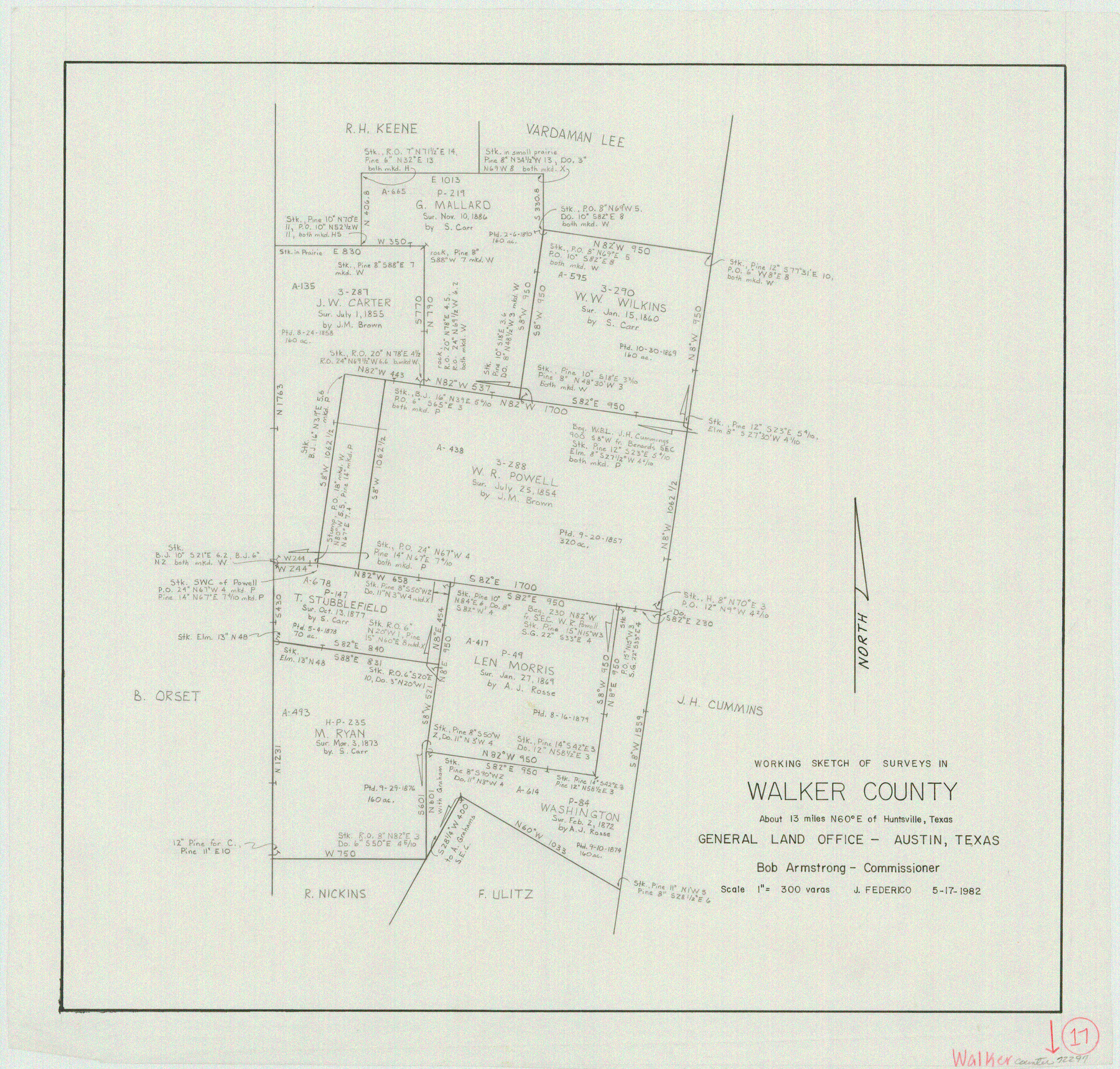
Walker County Working Sketch 17
-
Map/Doc
72297
-
Collection
General Map Collection
-
Object Dates
5/17/1982 (Creation Date)
-
People and Organizations
Jeff Federico (Draftsman)
-
Counties
Walker
-
Subjects
Surveying Working Sketch
-
Height x Width
19.9 x 20.8 inches
50.6 x 52.8 cm
-
Scale
1" = 300 varas
Part of: General Map Collection
Bexar County Working Sketch 4

Print $20.00
- Digital $50.00
Bexar County Working Sketch 4
1941
Size 19.4 x 21.7 inches
Map/Doc 67320
Menard County Working Sketch 18

Print $20.00
- Digital $50.00
Menard County Working Sketch 18
1946
Size 30.6 x 31.0 inches
Map/Doc 70965
Brewster County Working Sketch 102

Print $20.00
- Digital $50.00
Brewster County Working Sketch 102
1980
Size 40.0 x 43.3 inches
Map/Doc 67702
Fannin County Sketch File 9

Print $20.00
- Digital $50.00
Fannin County Sketch File 9
Size 20.7 x 16.0 inches
Map/Doc 11470
Sterling County Sketch File 11

Print $40.00
- Digital $50.00
Sterling County Sketch File 11
1929
Size 14.2 x 17.2 inches
Map/Doc 37148
Flight Mission No. CLL-3N, Frame 18, Willacy County

Print $20.00
- Digital $50.00
Flight Mission No. CLL-3N, Frame 18, Willacy County
1954
Size 18.4 x 22.1 inches
Map/Doc 87084
Parker County Working Sketch 13

Print $20.00
- Digital $50.00
Parker County Working Sketch 13
1978
Map/Doc 71463
Erath County Sketch File 5

Print $8.00
- Digital $50.00
Erath County Sketch File 5
Size 13.0 x 8.4 inches
Map/Doc 22263
Matagorda Bay Oil Area, Matagorda, Calhoun & Jackson Cos.

Print $40.00
- Digital $50.00
Matagorda Bay Oil Area, Matagorda, Calhoun & Jackson Cos.
1927
Size 34.9 x 66.8 inches
Map/Doc 2934
Anderson County Boundary File 9

Print $40.00
- Digital $50.00
Anderson County Boundary File 9
Size 19.7 x 58.3 inches
Map/Doc 49758
Irion County Working Sketch 11

Print $20.00
- Digital $50.00
Irion County Working Sketch 11
1959
Size 43.6 x 30.6 inches
Map/Doc 66420

You may also like
Terrell County Rolled Sketch 38

Print $20.00
- Digital $50.00
Terrell County Rolled Sketch 38
Size 22.7 x 18.0 inches
Map/Doc 7942
Menard County Boundary File 3a

Print $4.00
- Digital $50.00
Menard County Boundary File 3a
Size 10.6 x 8.1 inches
Map/Doc 57074
J. De Cordova's Map of the State of Texas Compiled from the records of the General Land Office of the State

Print $20.00
- Digital $50.00
J. De Cordova's Map of the State of Texas Compiled from the records of the General Land Office of the State
1849
Size 33.7 x 36.1 inches
Map/Doc 94026
Jeff Davis County Boundary File 1

Print $18.00
- Digital $50.00
Jeff Davis County Boundary File 1
Size 8.8 x 8.6 inches
Map/Doc 55492
Shelby County Sketch File 9

Print $4.00
- Digital $50.00
Shelby County Sketch File 9
1858
Size 9.4 x 8.2 inches
Map/Doc 36609
Chart of Aransas Harbor

Print $20.00
Chart of Aransas Harbor
1859
Size 14.2 x 17.4 inches
Map/Doc 76292
Texas-United States Boundary Line 3

Print $40.00
- Digital $50.00
Texas-United States Boundary Line 3
Size 54.6 x 10.5 inches
Map/Doc 74979
Subdivision of Halsell Cattle Company's Sod House Pasture Situated in Lamb County, Texas

Print $20.00
- Digital $50.00
Subdivision of Halsell Cattle Company's Sod House Pasture Situated in Lamb County, Texas
Size 37.3 x 28.2 inches
Map/Doc 92169
Railroad and County Map of Texas

Print $20.00
- Digital $50.00
Railroad and County Map of Texas
1887
Size 18.0 x 23.9 inches
Map/Doc 93959
Presidio County Rolled Sketch 123

Print $40.00
- Digital $50.00
Presidio County Rolled Sketch 123
Size 49.3 x 38.2 inches
Map/Doc 9798
[Northwest part of County showing surveys along Spring Creek, Harvey Creek, and Red Hollow Creek]
![90909, [Northwest part of County showing surveys along Spring Creek, Harvey Creek, and Red Hollow Creek], Twichell Survey Records](https://historictexasmaps.com/wmedia_w700/maps/90909-1.tif.jpg)
Print $20.00
- Digital $50.00
[Northwest part of County showing surveys along Spring Creek, Harvey Creek, and Red Hollow Creek]
Size 18.5 x 14.4 inches
Map/Doc 90909
Map of survey 189, T. C. R.R. Co. in Travis County, Texas

Print $20.00
- Digital $50.00
Map of survey 189, T. C. R.R. Co. in Travis County, Texas
1915
Size 18.5 x 15.2 inches
Map/Doc 663