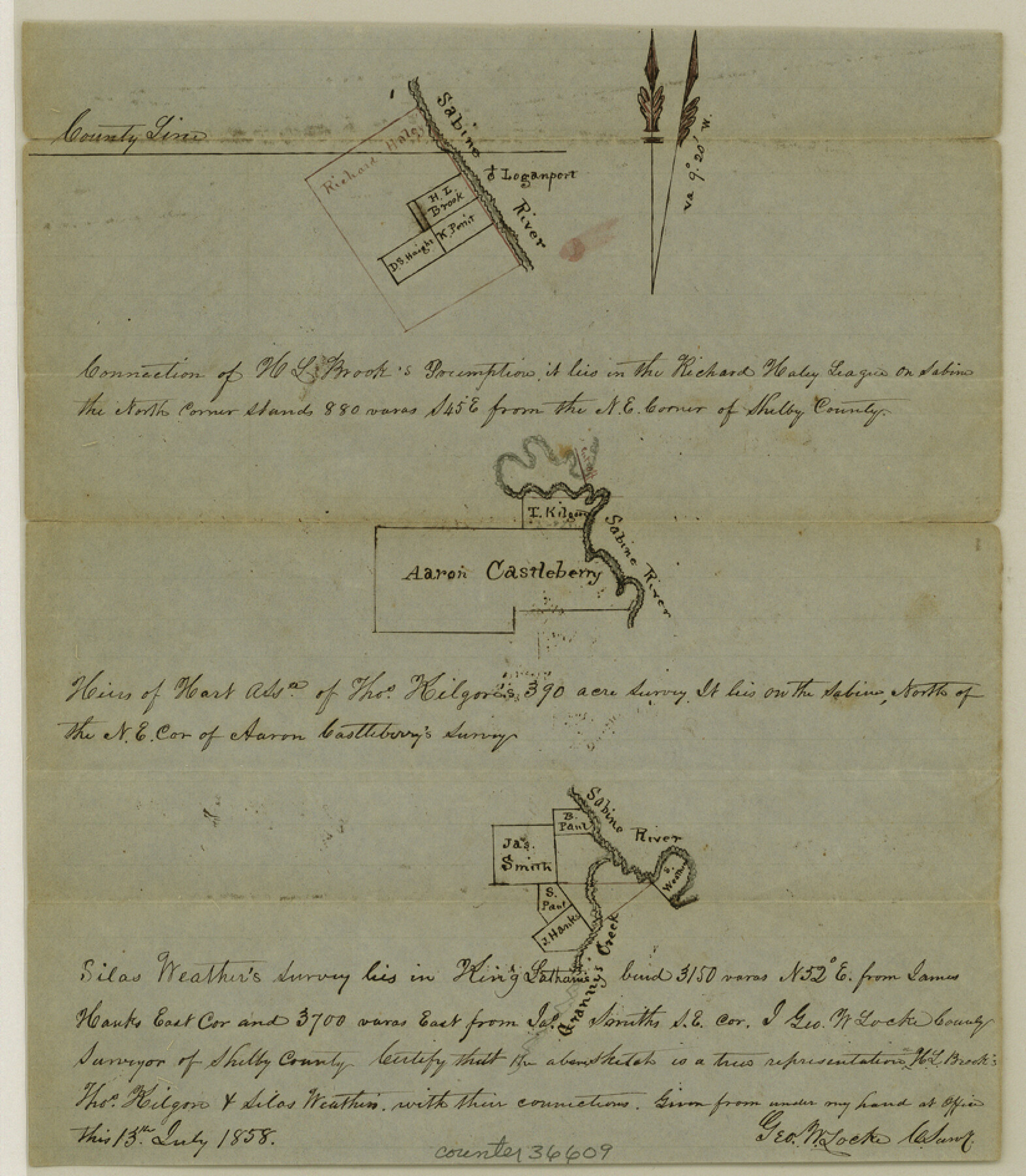
Shelby County Sketch File 9
[Three small sketches of three areas along the Sabine River from Panola County to Grannies Creek]
-
Map/Doc
36609
-
Collection
General Map Collection
-
Object Dates
7/13/1858 (Creation Date)
9/10/1858 (File Date)
-
People and Organizations
George W. Locke (Surveyor/Engineer)
-
Counties
Shelby Panola
-
Subjects
Surveying Sketch File
-
Height x Width
9.4 x 8.2 inches
23.9 x 20.8 cm
-
Medium
paper, manuscript
-
Features
Sabine River
Granny's Creek
Part of: General Map Collection
Collin County Working Sketch 6

Print $20.00
- Digital $50.00
Collin County Working Sketch 6
1996
Size 11.2 x 42.2 inches
Map/Doc 68100
[Right of Way Map, Belton Branch of the M.K.&T. RR.]
![64229, [Right of Way Map, Belton Branch of the M.K.&T. RR.], General Map Collection](https://historictexasmaps.com/wmedia_w700/maps/64229.tif.jpg)
Print $20.00
- Digital $50.00
[Right of Way Map, Belton Branch of the M.K.&T. RR.]
1896
Size 22.1 x 7.3 inches
Map/Doc 64229
Johnson County

Print $20.00
- Digital $50.00
Johnson County
1943
Size 39.8 x 37.0 inches
Map/Doc 77332
Randall County Rolled Sketch 9B

Print $20.00
- Digital $50.00
Randall County Rolled Sketch 9B
1985
Size 45.0 x 34.5 inches
Map/Doc 9810
Galveston County NRC Article 33.136 Sketch 5

Print $20.00
- Digital $50.00
Galveston County NRC Article 33.136 Sketch 5
2001
Size 23.5 x 19.1 inches
Map/Doc 61587
Map of the country adjacent to the left bank of the Rio Grande below Matamoros

Print $20.00
- Digital $50.00
Map of the country adjacent to the left bank of the Rio Grande below Matamoros
1847
Size 18.4 x 27.4 inches
Map/Doc 72869
McMullen County Working Sketch 34

Print $20.00
- Digital $50.00
McMullen County Working Sketch 34
1959
Size 25.9 x 26.0 inches
Map/Doc 70735
Kimble County Working Sketch 48

Print $20.00
- Digital $50.00
Kimble County Working Sketch 48
1951
Size 23.2 x 22.1 inches
Map/Doc 70116
Flight Mission No. DQO-2K, Frame 161, Galveston County

Print $20.00
- Digital $50.00
Flight Mission No. DQO-2K, Frame 161, Galveston County
1952
Size 18.7 x 22.4 inches
Map/Doc 85050
Trinity County Sketch File 37

Print $4.00
- Digital $50.00
Trinity County Sketch File 37
1921
Size 11.3 x 8.8 inches
Map/Doc 38591
Tarrant County Sketch File 19

Print $4.00
- Digital $50.00
Tarrant County Sketch File 19
Size 9.7 x 8.1 inches
Map/Doc 37721
University Lands Hudspeth County, Texas, Blocks A to N

Print $40.00
- Digital $50.00
University Lands Hudspeth County, Texas, Blocks A to N
1935
Size 38.6 x 55.4 inches
Map/Doc 2447
You may also like
Bailey County Rolled Sketch R and C

Print $51.00
- Digital $50.00
Bailey County Rolled Sketch R and C
1913
Size 10.1 x 16.0 inches
Map/Doc 42350
Grayson County Working Sketch 4

Print $20.00
- Digital $50.00
Grayson County Working Sketch 4
1939
Size 27.6 x 41.0 inches
Map/Doc 63243
[FT. W. & R. G. Ry. Right of Way Map, Winchell to Brady, McCulloch County, Texas]
![61414, [FT. W. & R. G. Ry. Right of Way Map, Winchell to Brady, McCulloch County, Texas], General Map Collection](https://historictexasmaps.com/wmedia_w700/maps/61414.tif.jpg)
Print $40.00
- Digital $50.00
[FT. W. & R. G. Ry. Right of Way Map, Winchell to Brady, McCulloch County, Texas]
1918
Size 38.2 x 122.0 inches
Map/Doc 61414
Flight Mission No. DAH-9M, Frame 161, Orange County

Print $20.00
- Digital $50.00
Flight Mission No. DAH-9M, Frame 161, Orange County
1953
Size 18.6 x 22.4 inches
Map/Doc 86860
Texas Coast Country along the line of the Sunset Route

Texas Coast Country along the line of the Sunset Route
1907
Map/Doc 96713
[Map of resurvey of H. & G.N. RR. Co. Blk. B2]
![89941, [Map of resurvey of H. & G.N. RR. Co. Blk. B2], Twichell Survey Records](https://historictexasmaps.com/wmedia_w700/maps/89941-1.tif.jpg)
Print $20.00
- Digital $50.00
[Map of resurvey of H. & G.N. RR. Co. Blk. B2]
1888
Size 36.6 x 37.7 inches
Map/Doc 89941
Ector County Rolled Sketch 9

Print $20.00
- Digital $50.00
Ector County Rolled Sketch 9
1940
Size 39.1 x 43.0 inches
Map/Doc 8837
Jackson County Sketch File 14

Print $40.00
- Digital $50.00
Jackson County Sketch File 14
Size 22.2 x 9.8 inches
Map/Doc 27660
Ector County Rolled Sketch RE

Print $20.00
- Digital $50.00
Ector County Rolled Sketch RE
1928
Size 41.2 x 38.7 inches
Map/Doc 8833
Chart of soundings through the different channels in Aransas and Matagorda Bays as taken in 1855 by Capt. R. B. Marey, U. S. A. [Inset: Harbour of Lamar and Live-Oak Pt.]
![72978, Chart of soundings through the different channels in Aransas and Matagorda Bays as taken in 1855 by Capt. R. B. Marey, U. S. A. [Inset: Harbour of Lamar and Live-Oak Pt.], General Map Collection](https://historictexasmaps.com/wmedia_w700/maps/72978.tif.jpg)
Print $20.00
- Digital $50.00
Chart of soundings through the different channels in Aransas and Matagorda Bays as taken in 1855 by Capt. R. B. Marey, U. S. A. [Inset: Harbour of Lamar and Live-Oak Pt.]
Size 28.4 x 18.3 inches
Map/Doc 72978
Karnes County Working Sketch 9

Print $20.00
- Digital $50.00
Karnes County Working Sketch 9
1962
Size 37.1 x 28.9 inches
Map/Doc 66657
Right of Way and Track Map Houston & Texas Central R.R. operated by the T. and N. O. R.R. Co., Fort Worth Branch

Print $40.00
- Digital $50.00
Right of Way and Track Map Houston & Texas Central R.R. operated by the T. and N. O. R.R. Co., Fort Worth Branch
1918
Size 31.3 x 57.1 inches
Map/Doc 64539