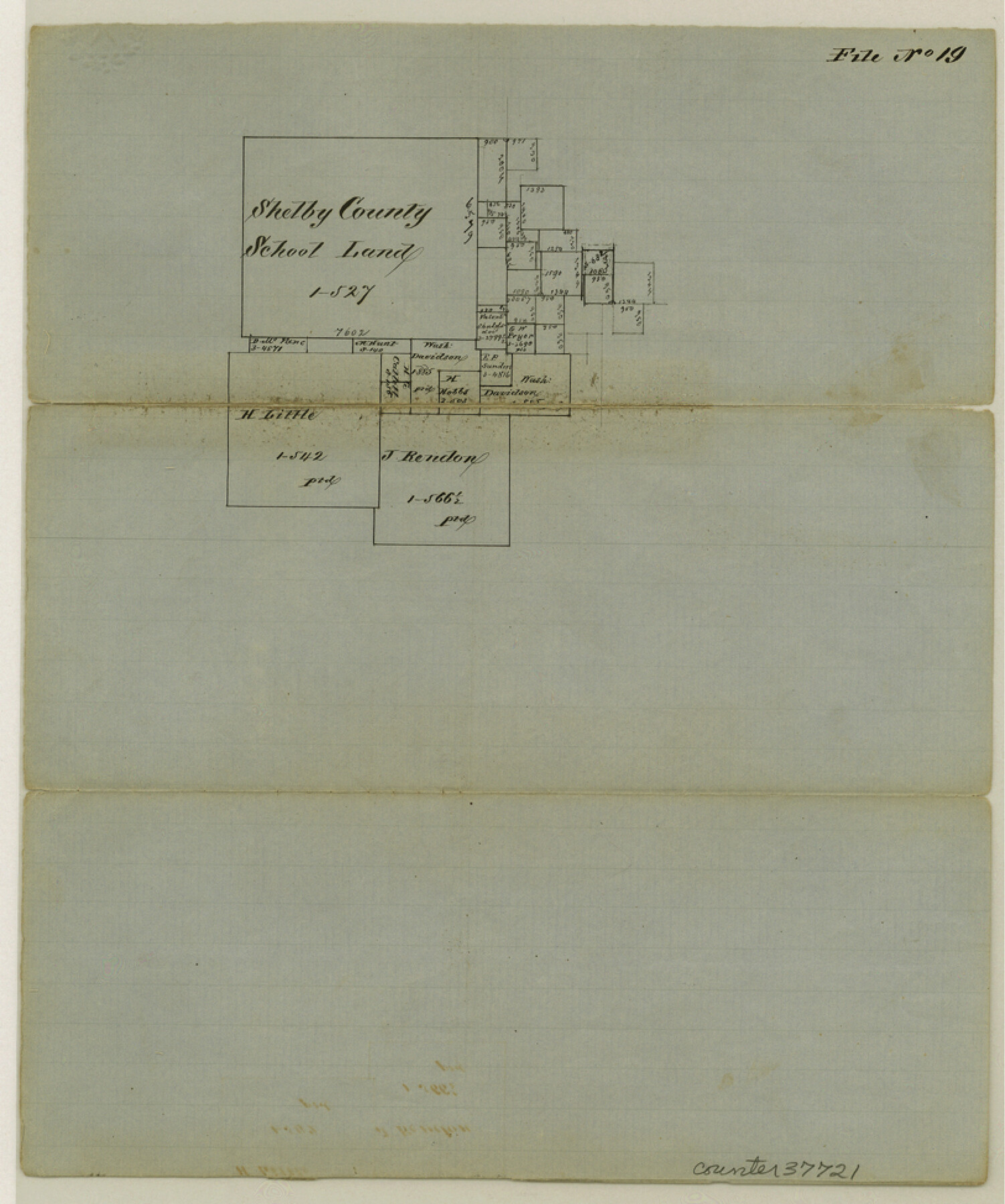
Tarrant County Sketch File 19
[Office sketch of the Shelby County School Land league and surveys to the south and east]
-
Map/Doc
37721
-
Collection
General Map Collection
-
Counties
Tarrant
-
Subjects
Surveying Sketch File
-
Height x Width
9.7 x 8.1 inches
24.6 x 20.6 cm
-
Medium
paper, manuscript
-
Features
Caddo Creek
Part of: General Map Collection
Frio County Working Sketch 15

Print $20.00
- Digital $50.00
Frio County Working Sketch 15
1961
Size 31.2 x 43.5 inches
Map/Doc 69289
Galveston Bay Entrance - Galveston and Texas City Harbors

Print $40.00
- Digital $50.00
Galveston Bay Entrance - Galveston and Texas City Harbors
Size 38.3 x 54.8 inches
Map/Doc 78271
Jefferson County Sketch File 43

Print $20.00
- Digital $50.00
Jefferson County Sketch File 43
1957
Size 26.6 x 19.6 inches
Map/Doc 11877
Jasper County Sketch File 25

Print $16.00
- Digital $50.00
Jasper County Sketch File 25
1941
Size 14.2 x 8.7 inches
Map/Doc 27826
Flight Mission No. CGI-1N, Frame 218, Cameron County

Print $20.00
- Digital $50.00
Flight Mission No. CGI-1N, Frame 218, Cameron County
1955
Size 18.6 x 22.1 inches
Map/Doc 84527
[County table portion of 1879 State of Texas map by Pressler & Langermann]
![3102, [County table portion of 1879 State of Texas map by Pressler & Langermann], General Map Collection](https://historictexasmaps.com/wmedia_w700/maps/3102-1.tif.jpg)
Print $20.00
- Digital $50.00
[County table portion of 1879 State of Texas map by Pressler & Langermann]
1879
Size 15.0 x 23.6 inches
Map/Doc 3102
Brown County Sketch File 29

Print $6.00
- Digital $50.00
Brown County Sketch File 29
1924
Size 14.3 x 8.9 inches
Map/Doc 16628
Webb County Rolled Sketch 39

Print $20.00
- Digital $50.00
Webb County Rolled Sketch 39
1941
Size 21.3 x 18.4 inches
Map/Doc 8194
Edwards County Working Sketch 131

Print $20.00
- Digital $50.00
Edwards County Working Sketch 131
1984
Size 21.0 x 18.6 inches
Map/Doc 69007
Collin County Boundary File 4 and 4a

Print $160.00
- Digital $50.00
Collin County Boundary File 4 and 4a
Size 11.9 x 8.5 inches
Map/Doc 51691
McMullen County Sketch File 45

Print $10.00
- Digital $50.00
McMullen County Sketch File 45
1943
Size 14.2 x 8.9 inches
Map/Doc 31429
Hartley County Working Sketch 7

Print $20.00
- Digital $50.00
Hartley County Working Sketch 7
1971
Size 20.1 x 25.1 inches
Map/Doc 66057
You may also like
Taylor County Working Sketch 8

Print $40.00
- Digital $50.00
Taylor County Working Sketch 8
1953
Size 73.2 x 43.1 inches
Map/Doc 69618
Brown County Rolled Sketch 2

Print $20.00
- Digital $50.00
Brown County Rolled Sketch 2
1984
Size 42.4 x 25.2 inches
Map/Doc 5349
Marion County Rolled Sketch JB

Print $40.00
- Digital $50.00
Marion County Rolled Sketch JB
Size 51.9 x 23.1 inches
Map/Doc 9488
Bastrop County Sketch File 6

Print $4.00
- Digital $50.00
Bastrop County Sketch File 6
1875
Size 8.8 x 7.8 inches
Map/Doc 14050
Wichita County Sketch File 12

Print $6.00
- Digital $50.00
Wichita County Sketch File 12
1881
Size 10.2 x 8.3 inches
Map/Doc 40074
Cottle County Boundary File 1

Print $22.00
- Digital $50.00
Cottle County Boundary File 1
Size 8.8 x 3.8 inches
Map/Doc 51944
Flight Mission No. DCL-7C, Frame 149, Kenedy County

Print $20.00
- Digital $50.00
Flight Mission No. DCL-7C, Frame 149, Kenedy County
1943
Size 18.7 x 22.5 inches
Map/Doc 86106
[Map of Texas showing Frisco Lines]
![95796, [Map of Texas showing Frisco Lines], Cobb Digital Map Collection](https://historictexasmaps.com/wmedia_w700/maps/95796.tif.jpg)
Print $20.00
- Digital $50.00
[Map of Texas showing Frisco Lines]
1910
Size 19.8 x 19.2 inches
Map/Doc 95796
Falls County Sketch File 2a

Print $2.00
- Digital $50.00
Falls County Sketch File 2a
1856
Size 8.4 x 10.9 inches
Map/Doc 22334
Moore County Working Sketch 10

Print $20.00
- Digital $50.00
Moore County Working Sketch 10
1951
Size 34.9 x 31.5 inches
Map/Doc 71192
[San Antonio & Aransas Pass Railway Co.]
![64260, [San Antonio & Aransas Pass Railway Co.], General Map Collection](https://historictexasmaps.com/wmedia_w700/maps/64260.tif.jpg)
Print $20.00
- Digital $50.00
[San Antonio & Aransas Pass Railway Co.]
Size 18.5 x 29.4 inches
Map/Doc 64260
Map of South Louisiana and Louisiana Continental Shelf showing Natural Gas Pipe Lines

Print $40.00
- Digital $50.00
Map of South Louisiana and Louisiana Continental Shelf showing Natural Gas Pipe Lines
Size 40.0 x 56.0 inches
Map/Doc 75906