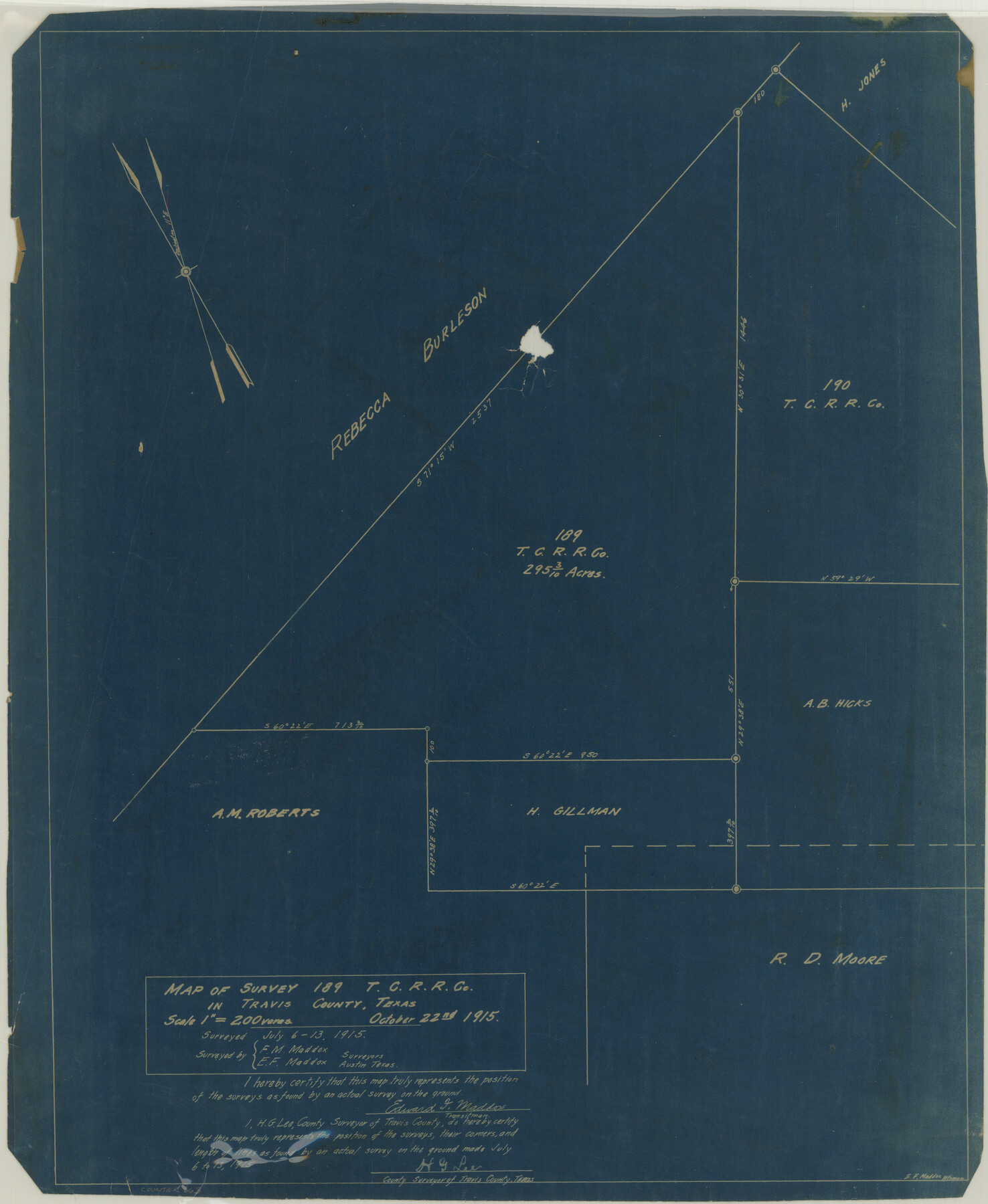
Map of survey 189, T. C. R.R. Co. in Travis County, Texas
-
Map/Doc
663
-
Collection
Maddox Collection
-
Object Dates
1915/10/22 (Creation Date)
1914/7/16 (Survey Date)
-
People and Organizations
H.G. Lee (Surveyor/Engineer)
E.F. Maddox (Draftsman)
Edward F. Maddox (Surveyor/Engineer)
F.M. Maddox (Surveyor/Engineer)
-
Counties
Travis Williamson
-
Height x Width
18.5 x 15.2 inches
47.0 x 38.6 cm
-
Medium
blueprint/diazo
-
Scale
1" = 200 varas
Part of: Maddox Collection
Map showing A. & N. W., Raymond Word #3, S.S. Hervey #496, and M. Farley #495 corrected to conform to the judgement in Cause #2888, Travis County District Court, State of Texas versus D. Sullivan, et al

Print $20.00
- Digital $50.00
Map showing A. & N. W., Raymond Word #3, S.S. Hervey #496, and M. Farley #495 corrected to conform to the judgement in Cause #2888, Travis County District Court, State of Texas versus D. Sullivan, et al
1915
Size 18.5 x 30.0 inches
Map/Doc 75812
Martin County, Texas

Print $20.00
- Digital $50.00
Martin County, Texas
1870
Size 22.9 x 18.0 inches
Map/Doc 391
Map of Lavaca County, Texas

Print $20.00
- Digital $50.00
Map of Lavaca County, Texas
1879
Size 22.8 x 25.0 inches
Map/Doc 561
Sketch H, Dickens County, Texas

Print $20.00
- Digital $50.00
Sketch H, Dickens County, Texas
1902
Size 16.0 x 14.3 inches
Map/Doc 4365
Plat of Surveys in Hidalgo Co.

Print $20.00
- Digital $50.00
Plat of Surveys in Hidalgo Co.
Size 18.2 x 9.3 inches
Map/Doc 405
[S. C. Vineyard and Adjacent Surveys, Aransas County, Texas]
![82558, [S. C. Vineyard and Adjacent Surveys, Aransas County, Texas], Maddox Collection](https://historictexasmaps.com/wmedia_w700/maps/82558.tif.jpg)
Print $20.00
- Digital $50.00
[S. C. Vineyard and Adjacent Surveys, Aransas County, Texas]
Size 24.7 x 18.6 inches
Map/Doc 82558
[Sketch of surveys in Knox County]
![555, [Sketch of surveys in Knox County], Maddox Collection](https://historictexasmaps.com/wmedia_w700/maps/555.tif.jpg)
Print $20.00
- Digital $50.00
[Sketch of surveys in Knox County]
Size 27.1 x 31.1 inches
Map/Doc 555
[Surveying Sketch of Jesse McGee, Jas McKim, W. S. Kennard, et al in Sabine and Newton Counties, Texas]
![5066, [Surveying Sketch of Jesse McGee, Jas McKim, W. S. Kennard, et al in Sabine and Newton Counties, Texas], Maddox Collection](https://historictexasmaps.com/wmedia_w700/maps/5066.tif.jpg)
Print $20.00
- Digital $50.00
[Surveying Sketch of Jesse McGee, Jas McKim, W. S. Kennard, et al in Sabine and Newton Counties, Texas]
1916
Size 32.0 x 37.5 inches
Map/Doc 5066
Angelina County, Texas

Print $20.00
- Digital $50.00
Angelina County, Texas
1879
Size 21.8 x 28.0 inches
Map/Doc 687
Map of the O-X Ranch in Cottle County, Texas

Print $20.00
- Digital $50.00
Map of the O-X Ranch in Cottle County, Texas
1916
Size 30.4 x 35.7 inches
Map/Doc 4439
[Surveying Sketch of John Knight, Champion Choate, A.M. Lejarza, et al in Hardin County, Texas - Exhibit "G"]
![75822, [Surveying Sketch of John Knight, Champion Choate, A.M. Lejarza, et al in Hardin County, Texas - Exhibit "G"], Maddox Collection](https://historictexasmaps.com/wmedia_w700/maps/75822.tif.jpg)
Print $20.00
- Digital $50.00
[Surveying Sketch of John Knight, Champion Choate, A.M. Lejarza, et al in Hardin County, Texas - Exhibit "G"]
Size 18.3 x 23.5 inches
Map/Doc 75822
Sketch of Crosby Co.

Print $20.00
- Digital $50.00
Sketch of Crosby Co.
1884
Size 14.8 x 12.5 inches
Map/Doc 506
You may also like

Terry County Working Sketch Graphic Index

Print $20.00
- Digital $50.00
Terry County Working Sketch Graphic Index
1970
Size 41.2 x 33.8 inches
Map/Doc 76712
Dimmit County Working Sketch 58

Print $20.00
- Digital $50.00
Dimmit County Working Sketch 58
2017
Size 24.2 x 36.2 inches
Map/Doc 94121
Hays County Working Sketch Graphic Index

Print $20.00
- Digital $50.00
Hays County Working Sketch Graphic Index
1946
Size 43.7 x 40.9 inches
Map/Doc 76573
Ward County Rolled Sketch 14

Print $20.00
- Digital $50.00
Ward County Rolled Sketch 14
1940
Size 18.5 x 26.2 inches
Map/Doc 8157
Presidio County Rolled Sketch 129

Print $20.00
- Digital $50.00
Presidio County Rolled Sketch 129
1989
Size 27.0 x 46.0 inches
Map/Doc 7399
Brewster County Working Sketch 71a

Print $40.00
- Digital $50.00
Brewster County Working Sketch 71a
1962
Size 43.5 x 56.0 inches
Map/Doc 67869
Amended Map of Wildorado Situated in Oldham County, Texas on Sections 14 & 15 Block Z3

Print $20.00
- Digital $50.00
Amended Map of Wildorado Situated in Oldham County, Texas on Sections 14 & 15 Block Z3
Size 14.9 x 18.4 inches
Map/Doc 92095

Val Verde County Sketch File Z14

Print $20.00
- Digital $50.00
Val Verde County Sketch File Z14
1899
Size 22.1 x 20.6 inches
Map/Doc 12556
Right of Way and Track Map, The Missouri, Kansas and Texas Ry. of Texas operated by the Missouri, Kansas and Texas Ry. of Texas, Henrietta Division

Print $40.00
- Digital $50.00
Right of Way and Track Map, The Missouri, Kansas and Texas Ry. of Texas operated by the Missouri, Kansas and Texas Ry. of Texas, Henrietta Division
1918
Size 25.1 x 56.4 inches
Map/Doc 64074
Mason County Working Sketch 1

Print $3.00
- Digital $50.00
Mason County Working Sketch 1
Size 10.7 x 16.2 inches
Map/Doc 70837