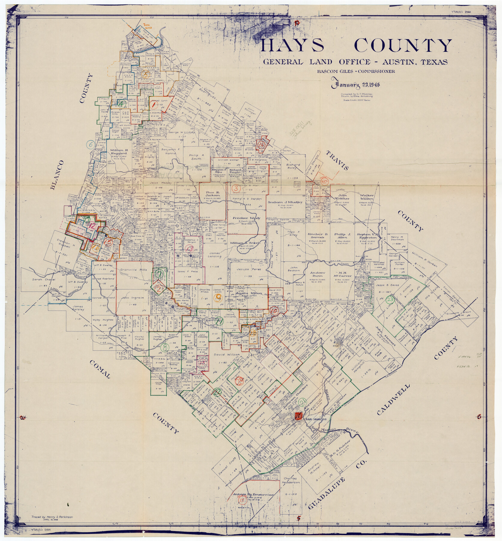
Hays County Working Sketch Graphic Index
-
Map/Doc
76573
-
Collection
General Map Collection
-
Object Dates
1/23/1946 (Creation Date)
-
People and Organizations
G.C. Morriss (Compiler)
Eltea Armstrong (Draftsman)
-
Counties
Hays
-
Subjects
County Surveying Working Sketch
-
Height x Width
43.7 x 40.9 inches
111.0 x 103.9 cm
-
Scale
1" = 2000 varas
-
Comments
Please note that Hays County Working Sketch 6 is missing and therefore no longer available.
Part of: General Map Collection
Coryell County Sketch File 21

Print $52.00
- Digital $50.00
Coryell County Sketch File 21
1940
Size 14.3 x 8.8 inches
Map/Doc 19381
Map of Fort Worth & Denver City Railway

Print $40.00
- Digital $50.00
Map of Fort Worth & Denver City Railway
1880
Size 25.3 x 50.3 inches
Map/Doc 64416
Sketches of Surveys in Jefferson County

Print $2.00
- Digital $50.00
Sketches of Surveys in Jefferson County
1841
Size 7.5 x 7.0 inches
Map/Doc 326
Cameron County Sketch File 3

Print $42.00
- Digital $50.00
Cameron County Sketch File 3
1930
Size 11.1 x 8.8 inches
Map/Doc 17023
Crockett County Sketch File F

Print $20.00
- Digital $50.00
Crockett County Sketch File F
1907
Size 26.3 x 15.7 inches
Map/Doc 11240
Map of The Surveyed Part of Peters Colony Texas

Print $40.00
- Digital $50.00
Map of The Surveyed Part of Peters Colony Texas
1852
Size 54.1 x 42.3 inches
Map/Doc 1965
Matagorda County Sketch File 7a

Print $8.00
- Digital $50.00
Matagorda County Sketch File 7a
1890
Size 14.2 x 8.9 inches
Map/Doc 30740
Angelina County Working Sketch 45

Print $20.00
- Digital $50.00
Angelina County Working Sketch 45
1976
Size 25.8 x 29.7 inches
Map/Doc 67128
Liberty County Working Sketch 51

Print $20.00
- Digital $50.00
Liberty County Working Sketch 51
1955
Size 17.5 x 38.5 inches
Map/Doc 70511
Pecos County Working Sketch 25

Print $20.00
- Digital $50.00
Pecos County Working Sketch 25
1929
Size 28.9 x 21.1 inches
Map/Doc 71496
Parker County Sketch File 11

Print $4.00
- Digital $50.00
Parker County Sketch File 11
1859
Size 12.8 x 8.1 inches
Map/Doc 33542
Wharton County Rolled Sketch 8

Print $20.00
- Digital $50.00
Wharton County Rolled Sketch 8
Size 24.4 x 39.2 inches
Map/Doc 8232
You may also like
Map of Carson County

Print $20.00
- Digital $50.00
Map of Carson County
1898
Size 41.2 x 33.8 inches
Map/Doc 4750
Kendall County Working Sketch 8

Print $20.00
- Digital $50.00
Kendall County Working Sketch 8
1951
Size 24.5 x 25.0 inches
Map/Doc 66680
[Blocks JK, JK4, JD, A1, and A2]
![90748, [Blocks JK, JK4, JD, A1, and A2], Twichell Survey Records](https://historictexasmaps.com/wmedia_w700/maps/90748-1.tif.jpg)
Print $20.00
- Digital $50.00
[Blocks JK, JK4, JD, A1, and A2]
Size 12.5 x 28.8 inches
Map/Doc 90748
Reagan County

Print $20.00
- Digital $50.00
Reagan County
1903
Size 45.6 x 36.2 inches
Map/Doc 16794
Hartley County Sketch File 1a

Print $4.00
- Digital $50.00
Hartley County Sketch File 1a
1890
Size 7.8 x 8.2 inches
Map/Doc 26083
Jeff Davis County Working Sketch 17

Print $3.00
- Digital $50.00
Jeff Davis County Working Sketch 17
1955
Size 10.9 x 9.0 inches
Map/Doc 66512
Flight Mission No. DIX-7P, Frame 91, Aransas County

Print $20.00
- Digital $50.00
Flight Mission No. DIX-7P, Frame 91, Aransas County
1956
Size 18.7 x 22.4 inches
Map/Doc 83885
Nacogdoches Co.

Print $40.00
- Digital $50.00
Nacogdoches Co.
1905
Size 50.7 x 42.0 inches
Map/Doc 10787

Flight Mission No. DCL-7C, Frame 142, Kenedy County

Print $20.00
- Digital $50.00
Flight Mission No. DCL-7C, Frame 142, Kenedy County
1943
Size 18.6 x 22.5 inches
Map/Doc 86099

Jackson County Rolled Sketch 3A

Print $20.00
- Digital $50.00
Jackson County Rolled Sketch 3A
1913
Size 23.2 x 22.6 inches
Map/Doc 6337