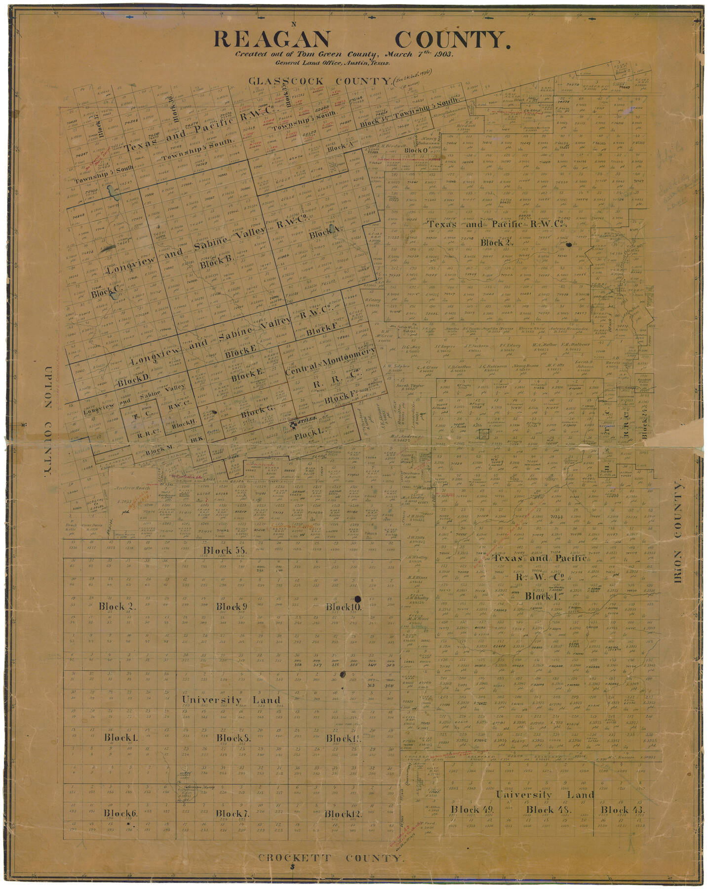
Reagan County
-
Map/Doc
16794
-
Collection
General Map Collection
-
Object Dates
3/7/1903 (Creation Date)
-
People and Organizations
Texas General Land Office (Publisher)
Ed. Schutze (Compiler)
-
Counties
Reagan
-
Subjects
County
-
Height x Width
45.6 x 36.2 inches
115.8 x 92.0 cm
-
Comments
Note on back: "Compiled by E. Schutze evidently about same time of East Tom Green Co. which was in 1892, Legg 5/12/05".
Help Save Texas History - Adopt Me! -
Features
Correll Creek
Stiles
Centralia Station
P&G
Grierson Spring
Concho River
Part of: General Map Collection
Motley County Sketch File 7a (N)

Print $40.00
- Digital $50.00
Motley County Sketch File 7a (N)
1895
Size 13.5 x 14.4 inches
Map/Doc 32014
Leon County Working Sketch 24

Print $20.00
- Digital $50.00
Leon County Working Sketch 24
1967
Size 23.3 x 29.0 inches
Map/Doc 70423
[Surveys in Austin's Colony along the west bank of the San Jacinto River]
![79, [Surveys in Austin's Colony along the west bank of the San Jacinto River], General Map Collection](https://historictexasmaps.com/wmedia_w700/maps/79-1.tif.jpg)
Print $20.00
- Digital $50.00
[Surveys in Austin's Colony along the west bank of the San Jacinto River]
1831
Size 25.0 x 22.0 inches
Map/Doc 79
[Surveys in the Bexar District along the Cibolo Creek]
![3168, [Surveys in the Bexar District along the Cibolo Creek], General Map Collection](https://historictexasmaps.com/wmedia_w700/maps/3168.tif.jpg)
Print $2.00
- Digital $50.00
[Surveys in the Bexar District along the Cibolo Creek]
1846
Size 5.1 x 6.7 inches
Map/Doc 3168
Calhoun County Rolled Sketch 26

Print $20.00
- Digital $50.00
Calhoun County Rolled Sketch 26
1941
Size 10.9 x 39.9 inches
Map/Doc 5374
Van Zandt County Boundary File 1

Print $32.00
- Digital $50.00
Van Zandt County Boundary File 1
Size 13.0 x 8.5 inches
Map/Doc 59626
Hardin County Sketch File 54

Print $20.00
- Digital $50.00
Hardin County Sketch File 54
1924
Size 16.6 x 17.9 inches
Map/Doc 11635
Crane County Sketch File 3a

Print $20.00
- Digital $50.00
Crane County Sketch File 3a
Size 20.8 x 13.0 inches
Map/Doc 11205
Liberty County Working Sketch 67

Print $20.00
- Digital $50.00
Liberty County Working Sketch 67
1971
Size 35.3 x 44.5 inches
Map/Doc 70527
Plan of the City of Galveston, Texas

Print $20.00
- Digital $50.00
Plan of the City of Galveston, Texas
1845
Size 18.4 x 27.8 inches
Map/Doc 62970
Flight Mission No. CRC-6R, Frame 11, Chambers County

Print $20.00
- Digital $50.00
Flight Mission No. CRC-6R, Frame 11, Chambers County
1956
Size 18.6 x 22.3 inches
Map/Doc 84965
Crockett County Sketch File 70

Print $40.00
- Digital $50.00
Crockett County Sketch File 70
1931
Size 15.0 x 17.4 inches
Map/Doc 11232
You may also like
Brewster County Sketch File N-7

Print $40.00
- Digital $50.00
Brewster County Sketch File N-7
1914
Size 16.7 x 13.9 inches
Map/Doc 15608
Bexar County Sketch File 47

Print $40.00
- Digital $50.00
Bexar County Sketch File 47
1896
Size 9.9 x 19.6 inches
Map/Doc 10925
Glasscock County

Print $20.00
- Digital $50.00
Glasscock County
1933
Size 46.2 x 38.6 inches
Map/Doc 95508

Flight Mission No. DCL-7C, Frame 31, Kenedy County

Print $20.00
- Digital $50.00
Flight Mission No. DCL-7C, Frame 31, Kenedy County
1943
Size 15.4 x 15.2 inches
Map/Doc 86023
[Dennis Corwin's Map of Survey for R. N. Graham]
![75781, [Dennis Corwin's Map of Survey for R. N. Graham], Maddox Collection](https://historictexasmaps.com/wmedia_w700/maps/75781-1.tif.jpg)
Print $2.00
- Digital $50.00
[Dennis Corwin's Map of Survey for R. N. Graham]
Size 11.1 x 8.4 inches
Map/Doc 75781
The Wonderful Lower Rio Grande Valley

Print $20.00
- Digital $50.00
The Wonderful Lower Rio Grande Valley
1909
Size 21.6 x 22.9 inches
Map/Doc 95798
San Patricio County NRC Article 33.136 Sketch 3

Print $3.00
- Digital $50.00
San Patricio County NRC Article 33.136 Sketch 3
Size 17.0 x 11.0 inches
Map/Doc 94694
Brazoria County Sketch File 55

Print $80.00
- Digital $50.00
Brazoria County Sketch File 55
1899
Size 14.9 x 55.0 inches
Map/Doc 10327
Presidio County Working Sketch 129

Print $20.00
- Digital $50.00
Presidio County Working Sketch 129
1988
Size 24.0 x 24.7 inches
Map/Doc 71807
Eastland County Working Sketch 7

Print $3.00
- Digital $50.00
Eastland County Working Sketch 7
1918
Size 15.6 x 10.7 inches
Map/Doc 68788
Parker County

Print $20.00
- Digital $50.00
Parker County
1942
Size 47.7 x 38.9 inches
Map/Doc 95609