Van Zandt County Boundary File 1
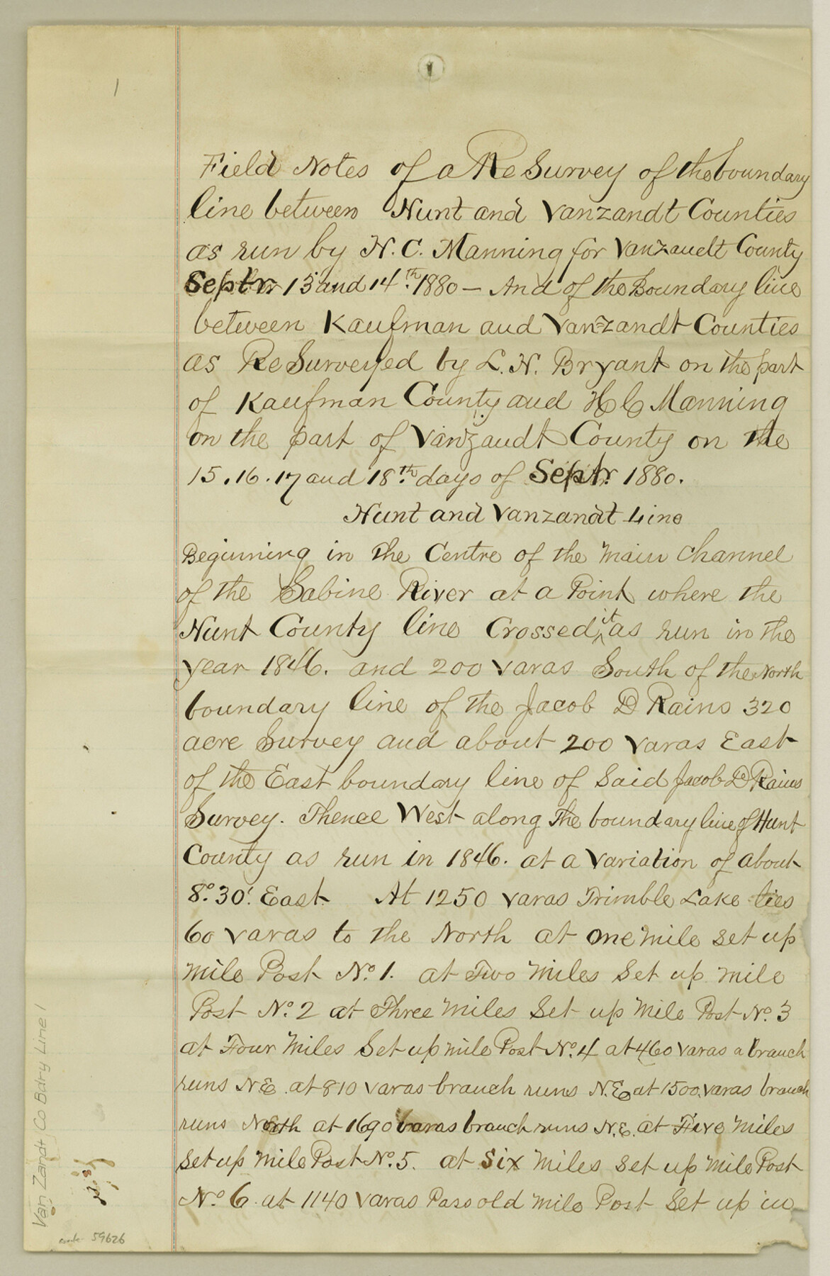
Field Notes of a ReSurvey of the boundary line between Hunt and Van Zandt Counties as run by H. C. Manning for Van Zandt County
-
Map/Doc
59626
-
Collection
General Map Collection
-
Counties
Van Zandt
-
Subjects
County Boundaries
-
Height x Width
13.0 x 8.5 inches
33.0 x 21.6 cm
Part of: General Map Collection
Flight Mission No. CUG-2P, Frame 24, Kleberg County

Print $20.00
- Digital $50.00
Flight Mission No. CUG-2P, Frame 24, Kleberg County
1956
Size 18.4 x 22.3 inches
Map/Doc 86188
Sherman County Rolled Sketch 13

Print $20.00
- Digital $50.00
Sherman County Rolled Sketch 13
1951
Size 14.3 x 30.7 inches
Map/Doc 7791
Culberson County Working Sketch 13

Print $20.00
- Digital $50.00
Culberson County Working Sketch 13
1922
Size 25.7 x 21.3 inches
Map/Doc 68465
Flight Mission No. DQN-2K, Frame 45, Calhoun County

Print $20.00
- Digital $50.00
Flight Mission No. DQN-2K, Frame 45, Calhoun County
1953
Size 18.4 x 22.2 inches
Map/Doc 84250
Edwards County Sketch File 16a

Print $24.00
- Digital $50.00
Edwards County Sketch File 16a
1903
Size 14.3 x 8.8 inches
Map/Doc 21720
Flight Mission No. DQO-3K, Frame 27, Galveston County

Print $20.00
- Digital $50.00
Flight Mission No. DQO-3K, Frame 27, Galveston County
1952
Size 18.7 x 22.5 inches
Map/Doc 85068
Controlled Mosaic by Jack Amman Photogrammetric Engineers, Inc - Sheet 33

Print $20.00
- Digital $50.00
Controlled Mosaic by Jack Amman Photogrammetric Engineers, Inc - Sheet 33
1954
Size 20.0 x 24.0 inches
Map/Doc 83486
Jim Hogg County Rolled Sketch 3

Print $20.00
- Digital $50.00
Jim Hogg County Rolled Sketch 3
1912
Size 28.2 x 20.2 inches
Map/Doc 6439
Pecos County Working Sketch Graphic Index - south part

Print $20.00
- Digital $50.00
Pecos County Working Sketch Graphic Index - south part
1976
Size 35.3 x 43.2 inches
Map/Doc 76665
[Sketch for Mineral Application 26501 - Sabine River, T. A. Oldhausen]
![2833, [Sketch for Mineral Application 26501 - Sabine River, T. A. Oldhausen], General Map Collection](https://historictexasmaps.com/wmedia_w700/maps/2833.tif.jpg)
Print $20.00
- Digital $50.00
[Sketch for Mineral Application 26501 - Sabine River, T. A. Oldhausen]
1931
Size 24.4 x 36.3 inches
Map/Doc 2833
Wheeler County Working Sketch 6

Print $40.00
- Digital $50.00
Wheeler County Working Sketch 6
1972
Size 49.8 x 47.4 inches
Map/Doc 72495
Controlled Mosaic by Jack Amman Photogrammetric Engineers, Inc - Sheet 26

Print $20.00
- Digital $50.00
Controlled Mosaic by Jack Amman Photogrammetric Engineers, Inc - Sheet 26
1954
Size 20.0 x 24.0 inches
Map/Doc 83477
You may also like
Crockett County Rolled Sketch 39

Print $20.00
- Digital $50.00
Crockett County Rolled Sketch 39
1935
Size 30.3 x 43.0 inches
Map/Doc 8705
Map of the Denison & South Eastern Rwy. showing the Location & Land Lines of the First Twenty-One Miles

Print $40.00
- Digital $50.00
Map of the Denison & South Eastern Rwy. showing the Location & Land Lines of the First Twenty-One Miles
1878
Size 24.1 x 70.4 inches
Map/Doc 64023
Kimble County Boundary File 3a

Print $36.00
- Digital $50.00
Kimble County Boundary File 3a
Size 8.8 x 8.2 inches
Map/Doc 64859
Right-of-Way and Track Map, Houston and Brazos Valley Ry. Co. operated by the Houston and Brazos Valley Ry. Co.

Print $40.00
- Digital $50.00
Right-of-Way and Track Map, Houston and Brazos Valley Ry. Co. operated by the Houston and Brazos Valley Ry. Co.
1918
Size 24.9 x 56.5 inches
Map/Doc 64607
Map of Hardin County, Texas

Print $20.00
- Digital $50.00
Map of Hardin County, Texas
1895
Size 22.1 x 20.9 inches
Map/Doc 499
General Highway Map, Jones County, Texas

Print $20.00
General Highway Map, Jones County, Texas
1961
Size 18.2 x 24.5 inches
Map/Doc 79546
Polk County Working Sketch 14

Print $20.00
- Digital $50.00
Polk County Working Sketch 14
1945
Size 32.3 x 37.7 inches
Map/Doc 71629
Hardin County Sketch File 3

Print $4.00
- Digital $50.00
Hardin County Sketch File 3
Size 7.7 x 4.6 inches
Map/Doc 25086
Working Sketch in Hutchinson County

Print $20.00
- Digital $50.00
Working Sketch in Hutchinson County
1922
Size 16.9 x 13.6 inches
Map/Doc 91251
Terry County Rolled Sketch 10

Print $20.00
- Digital $50.00
Terry County Rolled Sketch 10
2001
Size 25.2 x 23.8 inches
Map/Doc 76414
Real County Working Sketch 17

Print $20.00
- Digital $50.00
Real County Working Sketch 17
1941
Size 18.8 x 24.3 inches
Map/Doc 71909
Flight Mission No. DAG-24K, Frame 153, Matagorda County

Print $20.00
- Digital $50.00
Flight Mission No. DAG-24K, Frame 153, Matagorda County
1953
Size 17.3 x 18.8 inches
Map/Doc 86567