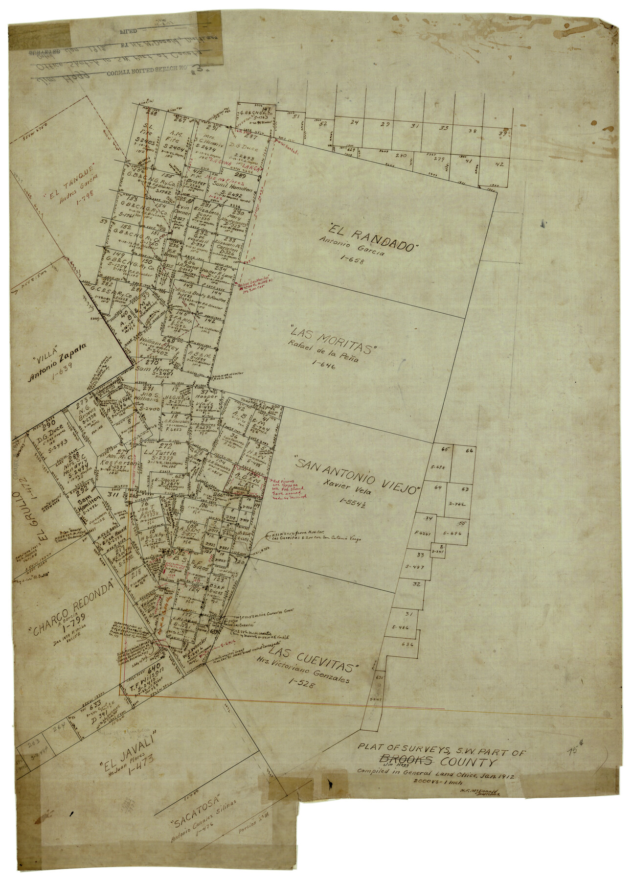
Jim Hogg County Rolled Sketch 3
Plat of surveys, SW part of Jim Hogg County
-
Map/Doc
6439
-
Collection
General Map Collection
-
Object Dates
1/1912 (Creation Date)
-
People and Organizations
H.F. McDonald (Draftsman)
-
Counties
Jim Hogg Starr Zapata
-
Subjects
Surveying Rolled Sketch
-
Height x Width
28.2 x 20.2 inches
71.6 x 51.3 cm
-
Medium
linen, manuscript
-
Scale
1" = 2000 varas
Part of: General Map Collection
Kimble County Working Sketch 97

Print $20.00
- Digital $50.00
Kimble County Working Sketch 97
2012
Size 42.8 x 36.6 inches
Map/Doc 93388
Leon County Working Sketch 13

Print $20.00
- Digital $50.00
Leon County Working Sketch 13
1956
Size 23.0 x 22.7 inches
Map/Doc 70412
Jefferson County Sketch File 43

Print $20.00
- Digital $50.00
Jefferson County Sketch File 43
1957
Size 26.6 x 19.6 inches
Map/Doc 11877
Jim Hogg County Boundary File 3

Print $4.00
- Digital $50.00
Jim Hogg County Boundary File 3
Size 8.8 x 11.2 inches
Map/Doc 55529
Hays County Working Sketch 10

Print $20.00
- Digital $50.00
Hays County Working Sketch 10
1949
Size 23.4 x 25.8 inches
Map/Doc 66084
Pecos County Rolled Sketch 184

Print $20.00
- Digital $50.00
Pecos County Rolled Sketch 184
1977
Size 44.4 x 30.0 inches
Map/Doc 7303
S. M. S. Flat Top Ranch

Print $6.00
- Digital $50.00
S. M. S. Flat Top Ranch
1955
Size 23.2 x 32.8 inches
Map/Doc 2102
La Salle County Boundary File 57b

Print $20.00
- Digital $50.00
La Salle County Boundary File 57b
Size 25.6 x 20.6 inches
Map/Doc 56258
El Paso County Rolled Sketch VD

Print $40.00
- Digital $50.00
El Paso County Rolled Sketch VD
1915
Size 18.4 x 67.4 inches
Map/Doc 8862
Trinity River, Owen Crossing Sheet/Elm Fork of Trinity River

Print $20.00
- Digital $50.00
Trinity River, Owen Crossing Sheet/Elm Fork of Trinity River
1914
Size 29.1 x 31.4 inches
Map/Doc 65201

San Patricio County Rolled Sketch 27A

Print $40.00
- Digital $50.00
San Patricio County Rolled Sketch 27A
Size 50.4 x 38.5 inches
Map/Doc 9891
You may also like
Edwards County Working Sketch 119

Print $20.00
- Digital $50.00
Edwards County Working Sketch 119
1975
Size 38.8 x 38.7 inches
Map/Doc 68995
Flight Mission No. DQN-2K, Frame 88, Calhoun County

Print $20.00
- Digital $50.00
Flight Mission No. DQN-2K, Frame 88, Calhoun County
1953
Size 18.6 x 22.3 inches
Map/Doc 84278
Presidio County Working Sketch 124

Print $20.00
- Digital $50.00
Presidio County Working Sketch 124
1984
Size 30.8 x 24.3 inches
Map/Doc 71802
Map of the Country Between the Frontiers of Arkansas and New Mexico embracing the section explored in 1849, 51, and 52

Print $40.00
Map of the Country Between the Frontiers of Arkansas and New Mexico embracing the section explored in 1849, 51, and 52
1852
Size 29.6 x 62.1 inches
Map/Doc 76219
Upton County Sketch File 10

Print $18.00
- Digital $50.00
Upton County Sketch File 10
1919
Size 13.5 x 8.7 inches
Map/Doc 38839
Flight Mission No. CRC-3R, Frame 164, Chambers County

Print $20.00
- Digital $50.00
Flight Mission No. CRC-3R, Frame 164, Chambers County
1956
Size 18.7 x 22.3 inches
Map/Doc 84846
Brazoria County NRC Article 33.136 Sketch 28

Print $24.00
Brazoria County NRC Article 33.136 Sketch 28
2025
Map/Doc 97473
Map of North America designed to accompany Smith's Geography for Schools

Print $20.00
- Digital $50.00
Map of North America designed to accompany Smith's Geography for Schools
1850
Size 12.0 x 9.9 inches
Map/Doc 93883
Flight Mission No. BQR-3K, Frame 161, Brazoria County

Print $20.00
- Digital $50.00
Flight Mission No. BQR-3K, Frame 161, Brazoria County
1952
Size 18.7 x 22.4 inches
Map/Doc 83988
Gray County Boundary File 5

Print $6.00
- Digital $50.00
Gray County Boundary File 5
Size 11.9 x 9.4 inches
Map/Doc 53893
Wheeler County Sketch File 3

Print $24.00
- Digital $50.00
Wheeler County Sketch File 3
1881
Size 12.9 x 8.4 inches
Map/Doc 39998
Runnels County Rolled Sketch 37

Print $20.00
- Digital $50.00
Runnels County Rolled Sketch 37
Size 37.8 x 38.2 inches
Map/Doc 9870