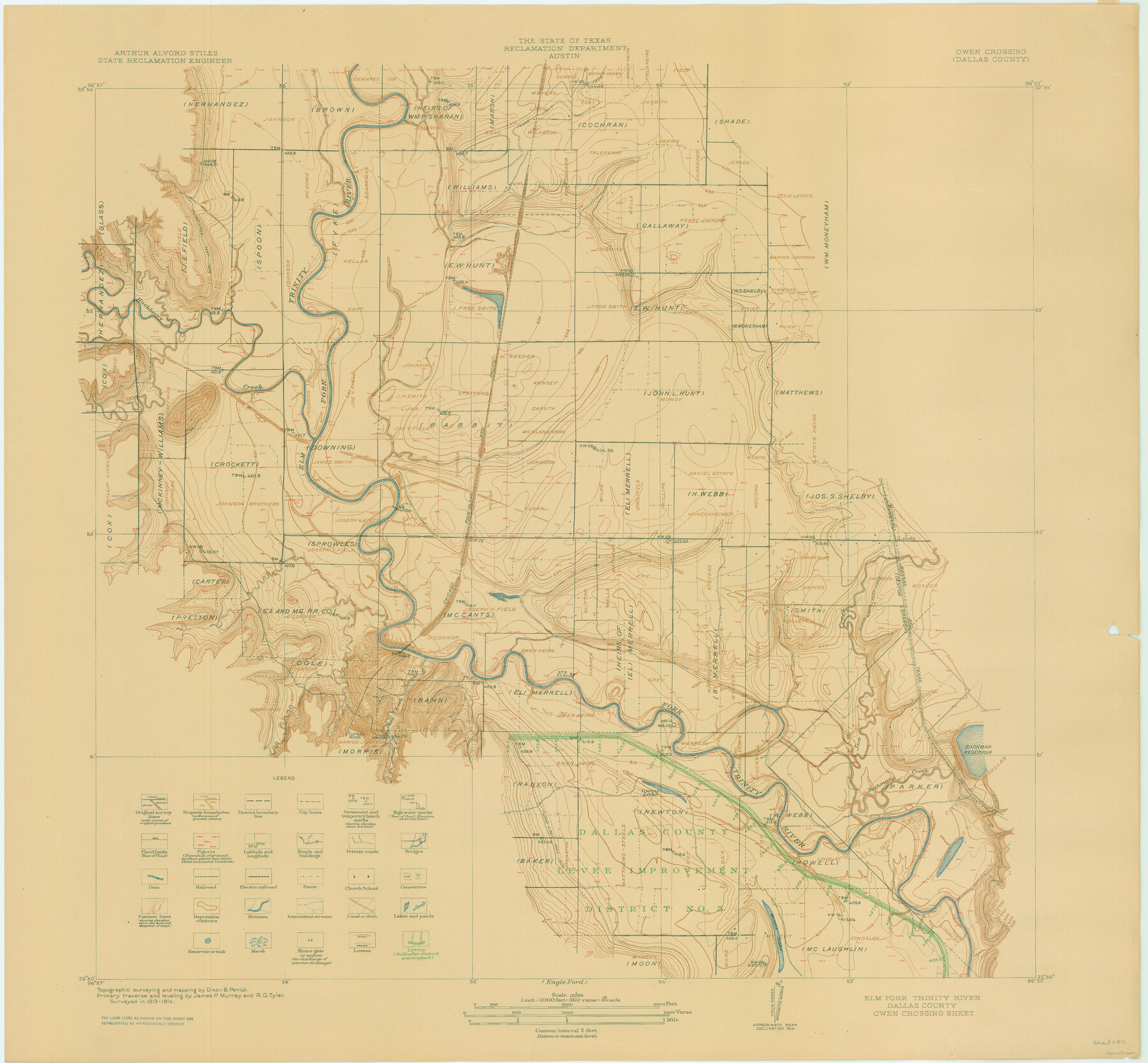
Trinity River, Owen Crossing Sheet/Elm Fork of Trinity River
-
Map/Doc
65201
-
Collection
General Map Collection
-
Object Dates
1914 (Creation Date)
-
People and Organizations
Texas State Reclamation Department (Publisher)
Dixon B. Penick (Surveyor/Engineer)
James P. Murray (Surveyor/Engineer)
R.G. Tyler (Surveyor/Engineer)
-
Counties
Dallas
-
Subjects
River Surveys Topographic
-
Height x Width
29.1 x 31.4 inches
73.9 x 79.8 cm
-
Comments
Owens Crossing Sheet located north of the Eagle Ford Sheet.
Part of: General Map Collection
Brewster County Sketch File N-13

Print $8.00
- Digital $50.00
Brewster County Sketch File N-13
1935
Size 14.3 x 8.7 inches
Map/Doc 15625
Flight Mission No. BRE-1P, Frame 66, Nueces County

Print $20.00
- Digital $50.00
Flight Mission No. BRE-1P, Frame 66, Nueces County
1956
Size 18.5 x 22.4 inches
Map/Doc 86648
W. M. Kuykendall Ranch, Matagorda County, Texas

Print $20.00
- Digital $50.00
W. M. Kuykendall Ranch, Matagorda County, Texas
1926
Size 24.3 x 39.6 inches
Map/Doc 3028
Hudspeth County Rolled Sketch 23

Print $40.00
- Digital $50.00
Hudspeth County Rolled Sketch 23
Size 43.7 x 70.3 inches
Map/Doc 9207
Flight Mission No. CRC-2R, Frame 60, Chambers County

Print $20.00
- Digital $50.00
Flight Mission No. CRC-2R, Frame 60, Chambers County
1956
Size 18.4 x 22.3 inches
Map/Doc 84731
Engineer's Office, Department of the Gulf Map No. 59, Texas prepared by order of Maj. Gen. N. P. Banks under direction of Capt. P. C. Hains, U. S. Engr. & Chief Engr., Dept. of the Gulf

Print $20.00
- Digital $50.00
Engineer's Office, Department of the Gulf Map No. 59, Texas prepared by order of Maj. Gen. N. P. Banks under direction of Capt. P. C. Hains, U. S. Engr. & Chief Engr., Dept. of the Gulf
1865
Size 18.3 x 27.5 inches
Map/Doc 72719
Medina County

Print $40.00
- Digital $50.00
Medina County
1915
Size 50.1 x 42.1 inches
Map/Doc 66924
Kleberg County Rolled Sketch 10-19

Print $20.00
- Digital $50.00
Kleberg County Rolled Sketch 10-19
1952
Size 38.2 x 36.7 inches
Map/Doc 9379
Flight Mission No. CRE-1R, Frame 63, Jackson County

Print $20.00
- Digital $50.00
Flight Mission No. CRE-1R, Frame 63, Jackson County
1956
Size 18.6 x 18.9 inches
Map/Doc 85326

Matagorda County Working Sketch 14

Print $40.00
- Digital $50.00
Matagorda County Working Sketch 14
1950
Size 42.9 x 50.5 inches
Map/Doc 70872
Cooke County Sketch File 14

Print $4.00
- Digital $50.00
Cooke County Sketch File 14
Size 10.3 x 8.2 inches
Map/Doc 19248
You may also like

Liberty County Working Sketch Graphic Index - west part

Print $20.00
- Digital $50.00
Liberty County Working Sketch Graphic Index - west part
1977
Size 45.7 x 34.5 inches
Map/Doc 76619
Runnels County Sketch File 33

Print $20.00
Runnels County Sketch File 33
1892
Size 19.1 x 23.1 inches
Map/Doc 12264
Map of the River Sabine from its Mouth on the Gulf of Mexico in the Sea to Logan's Ferry in Latitude 31° 58' 25" North

Print $20.00
Map of the River Sabine from its Mouth on the Gulf of Mexico in the Sea to Logan's Ferry in Latitude 31° 58' 25" North
1840
Size 35.5 x 9.1 inches
Map/Doc 79294
Rusk County Sketch File 45

Print $8.00
Rusk County Sketch File 45
1959
Size 11.3 x 8.8 inches
Map/Doc 35591
Oldham County Working Sketch Graphic Index

Print $40.00
- Digital $50.00
Oldham County Working Sketch Graphic Index
1925
Size 42.2 x 51.7 inches
Map/Doc 76657
[Blocks M18, M23, I, Z, and Block 47, Sections 16 - 28]
![91175, [Blocks M18, M23, I, Z, and Block 47, Sections 16 - 28], Twichell Survey Records](https://historictexasmaps.com/wmedia_w700/maps/91175-1.tif.jpg)
Print $20.00
- Digital $50.00
[Blocks M18, M23, I, Z, and Block 47, Sections 16 - 28]
Size 18.9 x 24.3 inches
Map/Doc 91175
Live Oak County Sketch File 14

Print $4.00
- Digital $50.00
Live Oak County Sketch File 14
1882
Size 13.3 x 8.8 inches
Map/Doc 30278
Van Zandt County Sketch File 35

Print $4.00
- Digital $50.00
Van Zandt County Sketch File 35
1862
Size 12.7 x 8.2 inches
Map/Doc 39474
Zapata County Working Sketch 13

Print $20.00
- Digital $50.00
Zapata County Working Sketch 13
1962
Size 28.7 x 29.6 inches
Map/Doc 62064

Dallas County Boundary File 7 and 7a and 7b

Print $26.00
- Digital $50.00
Dallas County Boundary File 7 and 7a and 7b
Size 11.2 x 8.6 inches
Map/Doc 52278