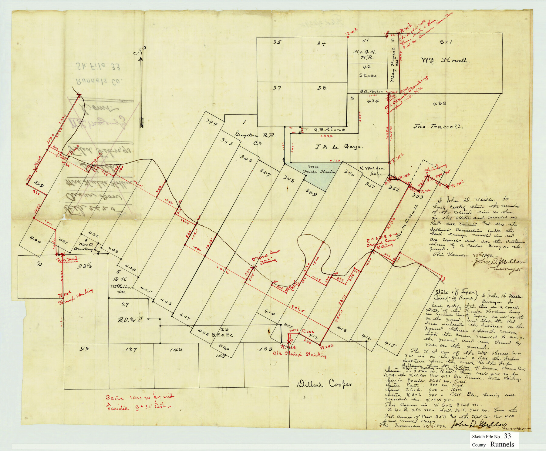
Runnels County Sketch File 33
[Sketch showing connections of surveys on either side of the Colorado River west of Ballinger]
-
Map/Doc
12264
-
Collection
General Map Collection
-
Object Dates
11/10/1892 (Creation Date)
2/10/1893 (File Date)
-
People and Organizations
John D. Miller (Surveyor/Engineer)
-
Counties
Runnels
-
Subjects
Surveying Sketch File
-
Height x Width
19.1 x 23.1 inches
48.5 x 58.7 cm
-
Medium
paper, manuscript
-
Scale
1" = 1000 varas
-
Features
Colorado River
Part of: General Map Collection
Flight Mission No. DQO-8K, Frame 58, Galveston County

Print $20.00
- Digital $50.00
Flight Mission No. DQO-8K, Frame 58, Galveston County
1952
Size 18.7 x 22.3 inches
Map/Doc 85165
Jasper County Sketch File 18

Print $32.00
- Digital $50.00
Jasper County Sketch File 18
1890
Size 12.6 x 7.9 inches
Map/Doc 27808
Brazoria County Working Sketch Graphic Index

Print $20.00
- Digital $50.00
Brazoria County Working Sketch Graphic Index
1947
Size 41.0 x 38.1 inches
Map/Doc 76471
Dawson County Sketch File 14

Print $4.00
- Digital $50.00
Dawson County Sketch File 14
Size 11.5 x 7.5 inches
Map/Doc 20547
Part of the boundary between the Republic of Texas and the United States, North of Sabine River, from the 72nd Mile Mound to Red River (Sheet No. 3)

Print $20.00
- Digital $50.00
Part of the boundary between the Republic of Texas and the United States, North of Sabine River, from the 72nd Mile Mound to Red River (Sheet No. 3)
1842
Size 33.8 x 26.2 inches
Map/Doc 4670
Origins of Exports and Destination of Imports at Houston during 1921

Print $20.00
- Digital $50.00
Origins of Exports and Destination of Imports at Houston during 1921
1921
Size 13.6 x 19.6 inches
Map/Doc 97170
Dimmit County Rolled Sketch 19

Print $20.00
- Digital $50.00
Dimmit County Rolled Sketch 19
1990
Size 45.4 x 41.7 inches
Map/Doc 8799
Kleberg County

Print $20.00
- Digital $50.00
Kleberg County
1913
Size 26.7 x 32.8 inches
Map/Doc 66894
Flight Mission No. CRC-3R, Frame 40, Chambers County

Print $20.00
- Digital $50.00
Flight Mission No. CRC-3R, Frame 40, Chambers County
1956
Size 18.6 x 22.3 inches
Map/Doc 84813
Rusk County Sketch File 34

Print $20.00
Rusk County Sketch File 34
1949
Size 33.4 x 28.2 inches
Map/Doc 10597

Bosque County Sketch File 22

Print $4.00
- Digital $50.00
Bosque County Sketch File 22
1863
Size 13.8 x 8.5 inches
Map/Doc 14804
You may also like
Flight Mission No. DAG-24K, Frame 147, Matagorda County

Print $20.00
- Digital $50.00
Flight Mission No. DAG-24K, Frame 147, Matagorda County
1953
Size 17.1 x 15.7 inches
Map/Doc 86561
Map of Padre Island Showing Location of Zoning Districts

Print $20.00
- Digital $50.00
Map of Padre Island Showing Location of Zoning Districts
1971
Size 26.2 x 18.5 inches
Map/Doc 4811
Connected Map of Austin's Colony (1892 tracing)

Print $40.00
- Digital $50.00
Connected Map of Austin's Colony (1892 tracing)
1837
Size 90.8 x 46.7 inches
Map/Doc 93358

Jack County Sketch File 12

Print $9.00
- Digital $50.00
Jack County Sketch File 12
Size 5.6 x 8.3 inches
Map/Doc 27533
Flight Mission No. CUG-1P, Frame 109, Kleberg County

Print $20.00
- Digital $50.00
Flight Mission No. CUG-1P, Frame 109, Kleberg County
1956
Size 18.6 x 22.3 inches
Map/Doc 86159
[Part of H. & G. N. Blocks 11 and 12]
![91565, [Part of H. & G. N. Blocks 11 and 12], Twichell Survey Records](https://historictexasmaps.com/wmedia_w700/maps/91565-1.tif.jpg)
Print $20.00
- Digital $50.00
[Part of H. & G. N. Blocks 11 and 12]
Size 21.5 x 16.7 inches
Map/Doc 91565
Galveston County Boundary File 32

Print $52.00
- Digital $50.00
Galveston County Boundary File 32
Size 16.7 x 13.6 inches
Map/Doc 53658
San Antonio & Surrounding Area

San Antonio & Surrounding Area
1997
Size 36.4 x 46.3 inches
Map/Doc 96867
Guadalupe County Sketch File 7b

Print $4.00
- Digital $50.00
Guadalupe County Sketch File 7b
Size 7.3 x 10.9 inches
Map/Doc 24670
Flight Mission No. BRE-2P, Frame 47, Nueces County

Print $20.00
- Digital $50.00
Flight Mission No. BRE-2P, Frame 47, Nueces County
1956
Size 18.6 x 22.6 inches
Map/Doc 86749
Oaklawn Subdivision

Print $20.00
- Digital $50.00
Oaklawn Subdivision
Size 17.6 x 22.4 inches
Map/Doc 92410