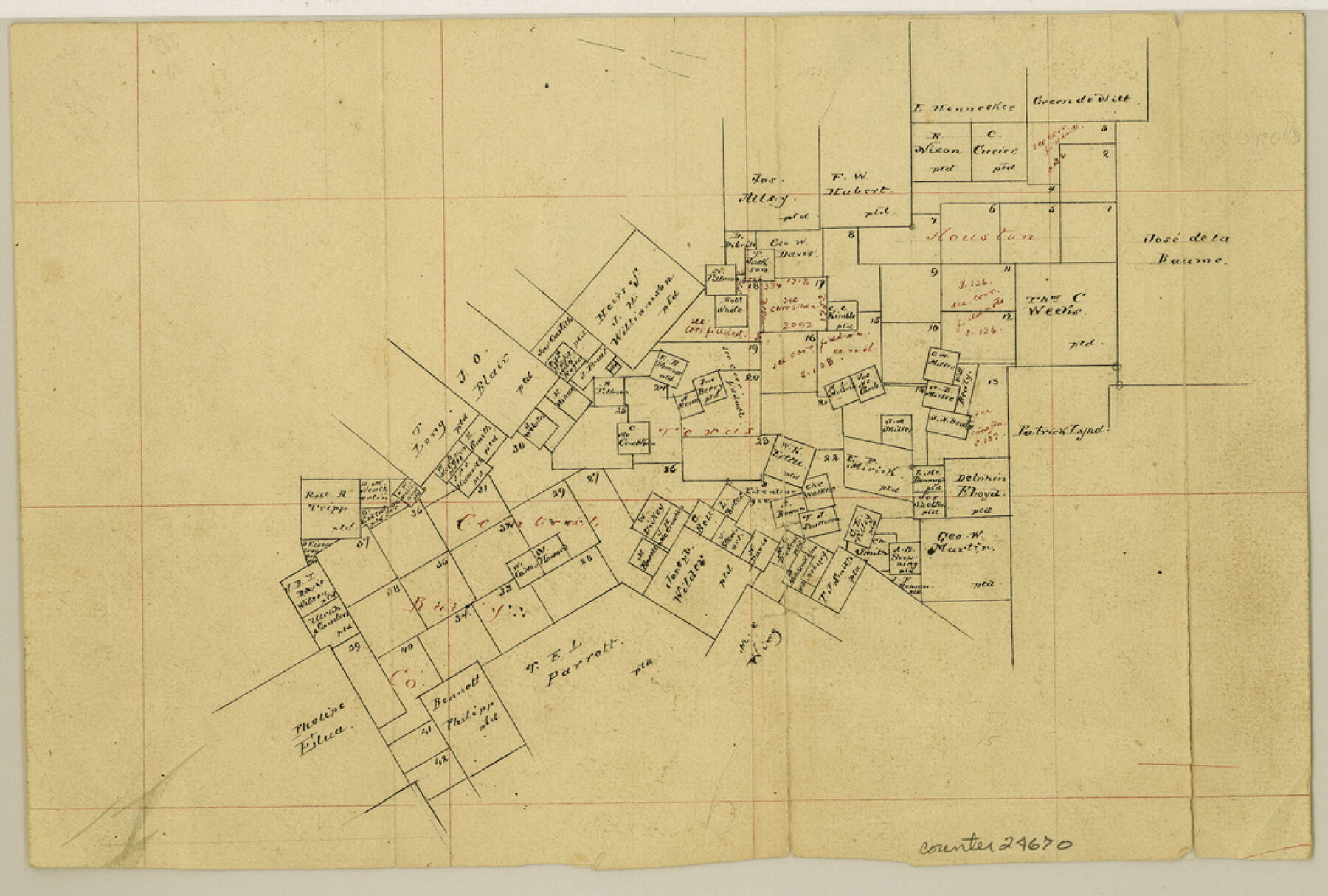
Guadalupe County Sketch File 7b
[Sketch of H. & T. C. RR. Co. surveys]
-
Map/Doc
24670
-
Collection
General Map Collection
-
Object Dates
1873/7/7 (File Date)
-
Counties
Guadalupe Wilson
-
Subjects
Surveying Sketch File
-
Height x Width
7.3 x 10.9 inches
18.5 x 27.7 cm
-
Medium
paper, manuscript
-
Scale
1:4000
Part of: General Map Collection
Shackelford County Working Sketch 7

Print $20.00
- Digital $50.00
Shackelford County Working Sketch 7
1963
Size 22.4 x 23.3 inches
Map/Doc 63847

[Sketch for Mineral Application 17237 / Mineral File 11855 - Neches River, Joe A. Sanders]
![65687, [Sketch for Mineral Application 17237 / Mineral File 11855 - Neches River, Joe A. Sanders], General Map Collection](https://historictexasmaps.com/wmedia_w700/maps/65687.tif.jpg)
Print $40.00
- Digital $50.00
[Sketch for Mineral Application 17237 / Mineral File 11855 - Neches River, Joe A. Sanders]
1927
Size 78.5 x 31.2 inches
Map/Doc 65687
[Map of Texas and Pacific Blocks from Brazos River westward through Palo Pinto, Stephens, Shackelford, Jones, Callahan, Taylor, Fisher, Nolan and Mitchell Counties]
![93456, [Map of Texas and Pacific Blocks from Brazos River westward through Palo Pinto, Stephens, Shackelford, Jones, Callahan, Taylor, Fisher, Nolan and Mitchell Counties], General Map Collection](https://historictexasmaps.com/wmedia_w700/maps/93456-1.tif.jpg)
Print $20.00
- Digital $50.00
[Map of Texas and Pacific Blocks from Brazos River westward through Palo Pinto, Stephens, Shackelford, Jones, Callahan, Taylor, Fisher, Nolan and Mitchell Counties]
Size 22.0 x 18.5 inches
Map/Doc 93456
Map of Ellis County

Print $20.00
- Digital $50.00
Map of Ellis County
1871
Size 18.9 x 26.6 inches
Map/Doc 4493
Jasper County Sketch File 12a

Print $16.00
- Digital $50.00
Jasper County Sketch File 12a
1881
Size 13.0 x 8.4 inches
Map/Doc 27794
Texas, Matagorda Bay, Matagorda Peninsula, Cany Creek to Tiger Island Channel

Print $40.00
- Digital $50.00
Texas, Matagorda Bay, Matagorda Peninsula, Cany Creek to Tiger Island Channel
1933
Size 31.4 x 48.6 inches
Map/Doc 69991
Flight Mission No. CLL-1N, Frame 192, Willacy County

Print $20.00
- Digital $50.00
Flight Mission No. CLL-1N, Frame 192, Willacy County
1954
Size 18.5 x 22.2 inches
Map/Doc 87062
Val Verde Co.

Print $20.00
- Digital $50.00
Val Verde Co.
1908
Size 40.9 x 38.5 inches
Map/Doc 63101
[Surveys in Montgomery County along the west San Jacinto River]
![28, [Surveys in Montgomery County along the west San Jacinto River], General Map Collection](https://historictexasmaps.com/wmedia_w700/maps/28.tif.jpg)
Print $2.00
- Digital $50.00
[Surveys in Montgomery County along the west San Jacinto River]
1841
Size 12.9 x 8.1 inches
Map/Doc 28
Uvalde County Rolled Sketch 9

Print $20.00
- Digital $50.00
Uvalde County Rolled Sketch 9
1924
Size 16.6 x 24.6 inches
Map/Doc 8094
Maps of Gulf Intracoastal Waterway, Texas - Sabine River to the Rio Grande and connecting waterways including ship channels

Print $20.00
- Digital $50.00
Maps of Gulf Intracoastal Waterway, Texas - Sabine River to the Rio Grande and connecting waterways including ship channels
1966
Size 14.6 x 20.5 inches
Map/Doc 62000
You may also like
Marion County Working Sketch 41

Print $40.00
- Digital $50.00
Marion County Working Sketch 41
1996
Size 34.0 x 48.5 inches
Map/Doc 70817
Brewster County Rolled Sketch 107

Print $20.00
- Digital $50.00
Brewster County Rolled Sketch 107
Size 22.2 x 11.2 inches
Map/Doc 5259

Briscoe County Sketch File G

Print $40.00
- Digital $50.00
Briscoe County Sketch File G
1918
Size 17.7 x 22.4 inches
Map/Doc 11004
Flight Mission No. CGI-3N, Frame 105, Cameron County

Print $20.00
- Digital $50.00
Flight Mission No. CGI-3N, Frame 105, Cameron County
1954
Size 18.5 x 22.2 inches
Map/Doc 84585
Runnels County Working Sketch 11

Print $20.00
- Digital $50.00
Runnels County Working Sketch 11
1949
Size 24.6 x 25.2 inches
Map/Doc 63607
Map of lands owned by R.E. Montgomery in Martin and Andrews County, Texas

Print $20.00
- Digital $50.00
Map of lands owned by R.E. Montgomery in Martin and Andrews County, Texas
Size 20.0 x 24.5 inches
Map/Doc 75764
Wheeler County Sketch File 5

Print $40.00
- Digital $50.00
Wheeler County Sketch File 5
1887
Size 20.2 x 24.2 inches
Map/Doc 12675
[Sketch for Mineral Application 24072, San Jacinto River]
![65594, [Sketch for Mineral Application 24072, San Jacinto River], General Map Collection](https://historictexasmaps.com/wmedia_w700/maps/65594.tif.jpg)
Print $20.00
- Digital $50.00
[Sketch for Mineral Application 24072, San Jacinto River]
1929
Size 25.8 x 20.8 inches
Map/Doc 65594
Upton County Sketch File 34

Print $40.00
- Digital $50.00
Upton County Sketch File 34
1941
Size 16.2 x 12.2 inches
Map/Doc 38884
Flight Mission No. CLL-3N, Frame 43, Willacy County

Print $20.00
- Digital $50.00
Flight Mission No. CLL-3N, Frame 43, Willacy County
1954
Size 18.3 x 22.0 inches
Map/Doc 87101
T. & N. O. R.R. Jefferson Co. North

Print $20.00
- Digital $50.00
T. & N. O. R.R. Jefferson Co. North
1917
Size 13.4 x 33.5 inches
Map/Doc 64058