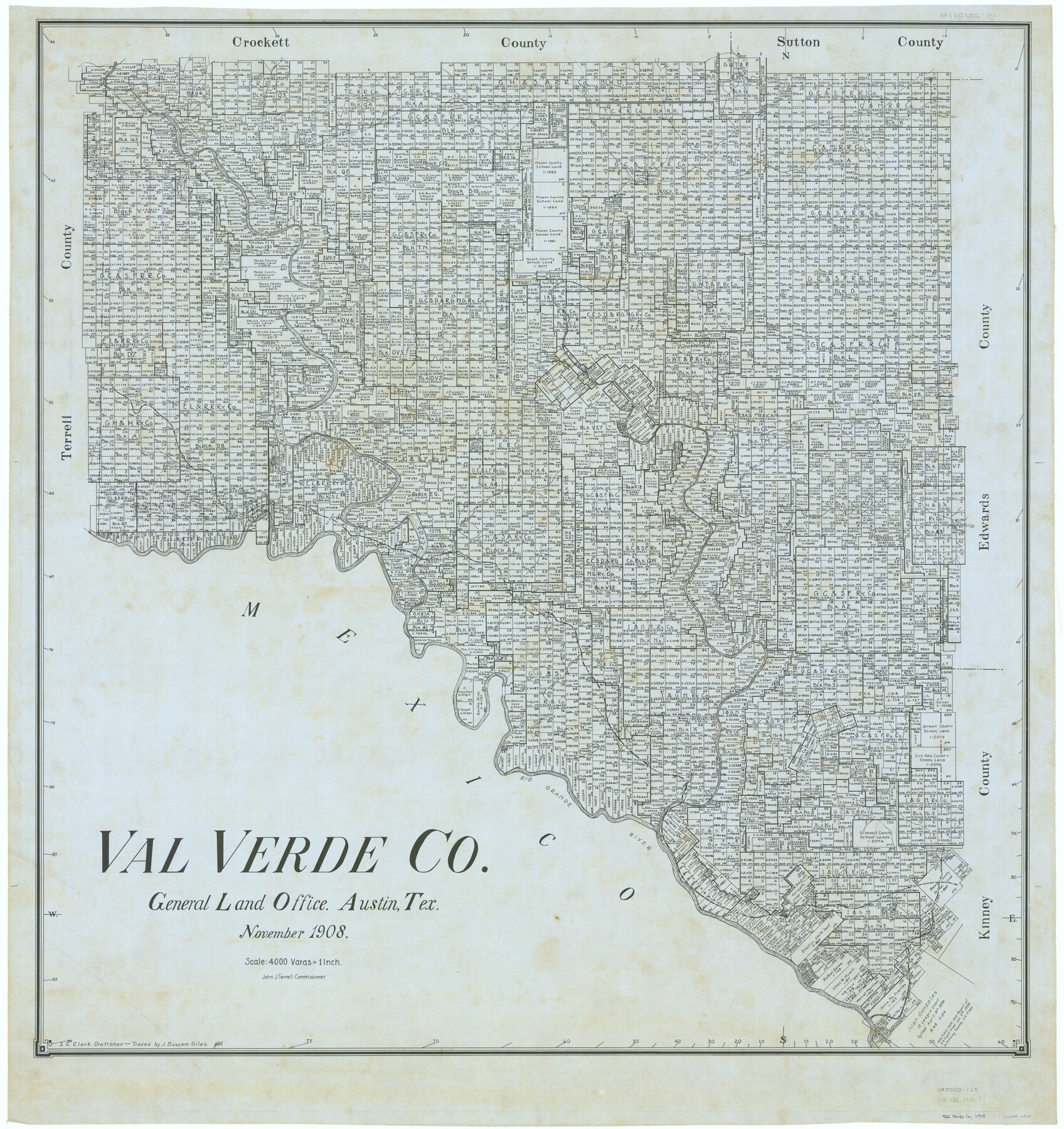
Val Verde Co.
-
Map/Doc
63101
-
Collection
General Map Collection
-
Object Dates
1908 (Creation Date)
-
People and Organizations
Texas General Land Office (Publisher)
S.C. Clark (Draftsman)
S.C. Clark (Compiler)
-
Counties
Val Verde
-
Subjects
County
-
Height x Width
40.9 x 38.5 inches
103.9 x 97.8 cm
-
Comments
Traced by J. Bascom Giles.
Part of: General Map Collection
Sketch K Showing the Progress of the Survey of the Columbia River, Oregon

Print $20.00
- Digital $50.00
Sketch K Showing the Progress of the Survey of the Columbia River, Oregon
1852
Size 9.8 x 12.7 inches
Map/Doc 97237
Donley County Sketch File 10

Print $8.00
- Digital $50.00
Donley County Sketch File 10
1889
Size 9.6 x 6.1 inches
Map/Doc 21240
Potter County Sketch File 23

Print $4.00
- Digital $50.00
Potter County Sketch File 23
Size 11.1 x 8.7 inches
Map/Doc 34421
Brooks County Boundary File 2

Print $8.00
- Digital $50.00
Brooks County Boundary File 2
Size 8.6 x 11.3 inches
Map/Doc 50839
Van Zandt County Rolled Sketch 3

Print $20.00
- Digital $50.00
Van Zandt County Rolled Sketch 3
1946
Size 23.6 x 36.7 inches
Map/Doc 8145

Brazoria County Sketch File 34

Print $4.00
- Digital $50.00
Brazoria County Sketch File 34
Size 14.3 x 8.9 inches
Map/Doc 15041
Leon County Sketch File 34

Print $10.00
- Digital $50.00
Leon County Sketch File 34
1962
Size 11.1 x 8.7 inches
Map/Doc 94787
Swisher County Sketch File 11

Print $58.00
- Digital $50.00
Swisher County Sketch File 11
1917
Size 9.1 x 8.3 inches
Map/Doc 37633
Rains County Working Sketch 2

Print $20.00
- Digital $50.00
Rains County Working Sketch 2
Size 14.0 x 12.2 inches
Map/Doc 71828
Jasper County Sketch File 31

Print $20.00
- Digital $50.00
Jasper County Sketch File 31
Size 21.6 x 24.7 inches
Map/Doc 11852
Chambers County Aerial Photograph Index Sheet 3

Print $20.00
- Digital $50.00
Chambers County Aerial Photograph Index Sheet 3
1956
Size 20.5 x 15.7 inches
Map/Doc 83684
You may also like
Clay County Sketch File 33

Print $4.00
- Digital $50.00
Clay County Sketch File 33
Size 12.0 x 7.6 inches
Map/Doc 18459
Crockett County Rolled Sketch 74

Print $20.00
- Digital $50.00
Crockett County Rolled Sketch 74
1949
Size 19.4 x 24.9 inches
Map/Doc 5615
Corpus Christi Bay

Print $20.00
- Digital $50.00
Corpus Christi Bay
1976
Size 36.2 x 47.8 inches
Map/Doc 73476
General Highway Map, Menard County, Texas

Print $20.00
General Highway Map, Menard County, Texas
1940
Size 18.5 x 24.8 inches
Map/Doc 79196
Angelina County Sketch File 23

Print $20.00
- Digital $50.00
Angelina County Sketch File 23
Size 13.5 x 8.1 inches
Map/Doc 13053
Flight Mission No. BRE-2P, Frame 107, Nueces County

Print $20.00
- Digital $50.00
Flight Mission No. BRE-2P, Frame 107, Nueces County
1956
Size 18.5 x 22.7 inches
Map/Doc 86792
Hopkins County Sketch File 23

Print $4.00
- Digital $50.00
Hopkins County Sketch File 23
1871
Size 12.6 x 8.4 inches
Map/Doc 26732
Real County Working Sketch 27

Print $20.00
- Digital $50.00
Real County Working Sketch 27
1947
Size 29.8 x 29.2 inches
Map/Doc 71919
Hidalgo County Sketch File 15

Print $12.00
- Digital $50.00
Hidalgo County Sketch File 15
1878
Size 10.1 x 7.9 inches
Map/Doc 26431
Somervell County Rolled Sketch B

Print $20.00
- Digital $50.00
Somervell County Rolled Sketch B
Size 18.8 x 19.9 inches
Map/Doc 7792
Dimmit County Boundary File 10a

Print $4.00
- Digital $50.00
Dimmit County Boundary File 10a
Size 14.0 x 8.5 inches
Map/Doc 52611
[Surveys along the boundary between Jasper and Jefferson Counties]
![99, [Surveys along the boundary between Jasper and Jefferson Counties], General Map Collection](https://historictexasmaps.com/wmedia_w700/maps/99.tif.jpg)
Print $3.00
- Digital $50.00
[Surveys along the boundary between Jasper and Jefferson Counties]
1841
Size 9.3 x 16.9 inches
Map/Doc 99