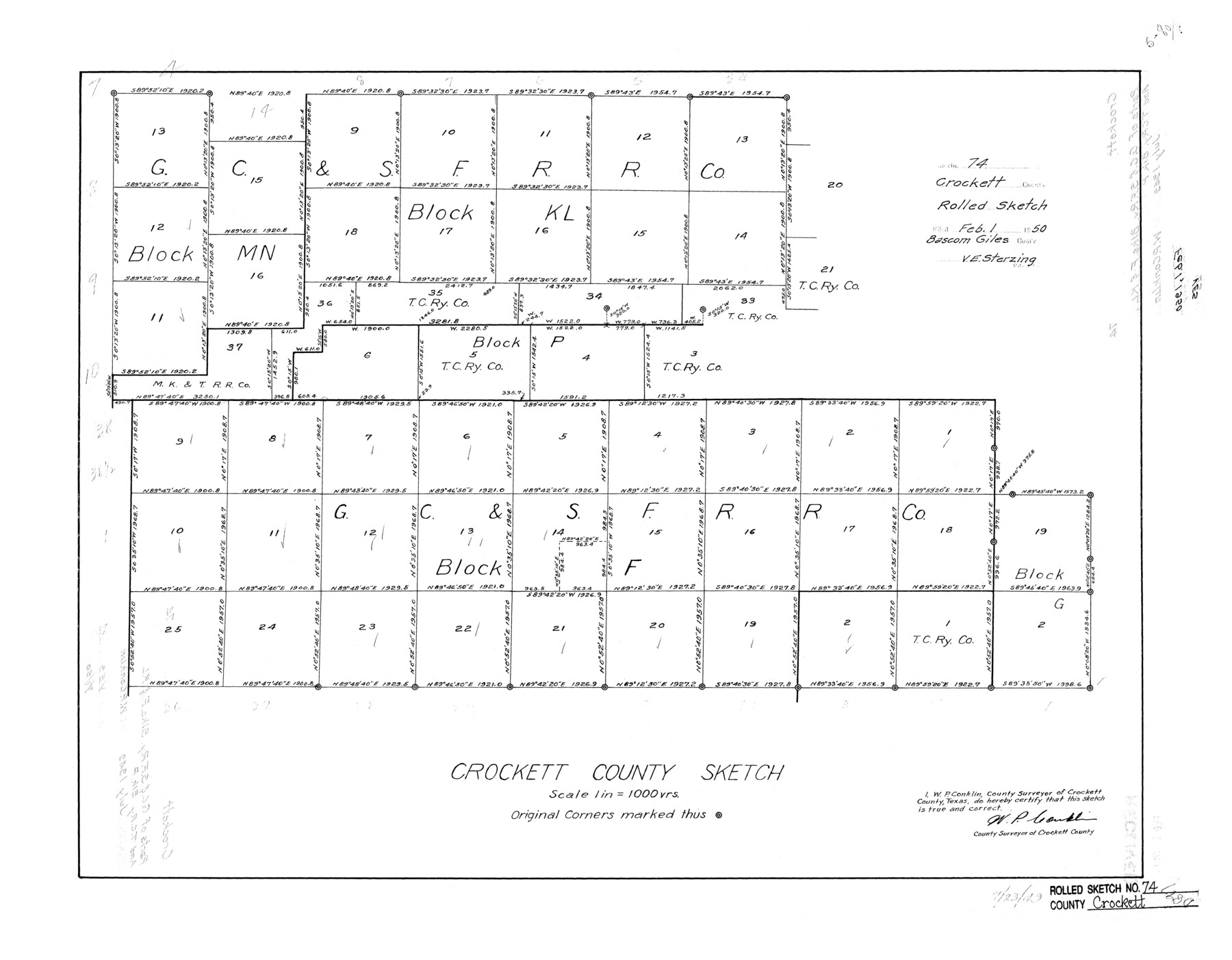
Crockett County Rolled Sketch 74
Crockett County Sketch
-
Map/Doc
5615
-
Collection
General Map Collection
-
Object Dates
1949 (Creation Date)
1950/2/1 (File Date)
-
People and Organizations
W.P. Conklin (Surveyor/Engineer)
-
Counties
Crockett
-
Subjects
Surveying Rolled Sketch
-
Height x Width
19.4 x 24.9 inches
49.3 x 63.2 cm
-
Scale
1" = 1000 varas
Part of: General Map Collection
[Surveys in Williamson County]
![78374, [Surveys in Williamson County], General Map Collection](https://historictexasmaps.com/wmedia_w700/maps/78374.tif.jpg)
Print $2.00
- Digital $50.00
[Surveys in Williamson County]
1846
Size 9.2 x 11.8 inches
Map/Doc 78374
Hockley County Sketch File 6

Print $20.00
- Digital $50.00
Hockley County Sketch File 6
Size 24.9 x 33.0 inches
Map/Doc 11769
Hall County Rolled Sketch 5

Print $20.00
- Digital $50.00
Hall County Rolled Sketch 5
1914
Size 30.2 x 37.1 inches
Map/Doc 6049
Walker County Working Sketch 4

Print $20.00
- Digital $50.00
Walker County Working Sketch 4
1934
Size 34.9 x 29.7 inches
Map/Doc 72284
Crockett County Rolled Sketch 78

Print $20.00
- Digital $50.00
Crockett County Rolled Sketch 78
1952
Size 20.5 x 19.5 inches
Map/Doc 5619
Map of Part of Texas Prison System, Blue Ridge State Farm near Camp No. 1 Showing Buildings and Property Lines

Print $20.00
- Digital $50.00
Map of Part of Texas Prison System, Blue Ridge State Farm near Camp No. 1 Showing Buildings and Property Lines
Size 20.3 x 25.4 inches
Map/Doc 62980
Map of Jasper County

Print $20.00
- Digital $50.00
Map of Jasper County
1839
Size 41.6 x 28.5 inches
Map/Doc 3711
Brewster County Sketch File NS-X

Print $42.00
- Digital $50.00
Brewster County Sketch File NS-X
1882
Size 20.1 x 10.5 inches
Map/Doc 15943
Kent County Rolled Sketch 3

Print $20.00
- Digital $50.00
Kent County Rolled Sketch 3
1950
Size 27.6 x 25.3 inches
Map/Doc 6474
Runnels County Rolled Sketch 40

Print $20.00
- Digital $50.00
Runnels County Rolled Sketch 40
Size 32.3 x 38.9 inches
Map/Doc 7528
Collingsworth County

Print $20.00
- Digital $50.00
Collingsworth County
1971
Size 42.5 x 36.2 inches
Map/Doc 73111
Kimble County Rolled Sketch 31

Print $20.00
- Digital $50.00
Kimble County Rolled Sketch 31
Size 21.1 x 27.4 inches
Map/Doc 6521
You may also like
The T. B. Duggan Subdivision of League 125 and N 3/5 of League 126, Coke County School Lands, Cochran County, Texas

Print $20.00
- Digital $50.00
The T. B. Duggan Subdivision of League 125 and N 3/5 of League 126, Coke County School Lands, Cochran County, Texas
1920
Size 14.9 x 21.5 inches
Map/Doc 90300
Roberts County

Print $20.00
- Digital $50.00
Roberts County
1878
Size 20.1 x 18.0 inches
Map/Doc 3991

Flight Mission No. BRA-7M, Frame 151, Jefferson County

Print $20.00
- Digital $50.00
Flight Mission No. BRA-7M, Frame 151, Jefferson County
1953
Size 18.7 x 22.6 inches
Map/Doc 85545
McCulloch County Working Sketch 18

Print $20.00
- Digital $50.00
McCulloch County Working Sketch 18
1997
Size 42.9 x 32.8 inches
Map/Doc 70693
Fort Bend County Working Sketch 8

Print $20.00
- Digital $50.00
Fort Bend County Working Sketch 8
1922
Size 24.9 x 17.6 inches
Map/Doc 69214
Flight Mission No. DCL-4C, Frame 7, Kenedy County

Print $20.00
- Digital $50.00
Flight Mission No. DCL-4C, Frame 7, Kenedy County
1943
Size 18.6 x 22.3 inches
Map/Doc 85808
Culberson County Working Sketch 73

Print $40.00
- Digital $50.00
Culberson County Working Sketch 73
1975
Size 48.7 x 33.4 inches
Map/Doc 68527
Lampasas County Sketch File B

Print $20.00
- Digital $50.00
Lampasas County Sketch File B
1886
Size 15.0 x 22.4 inches
Map/Doc 11977
Galveston County Sketch File 25

Print $2.00
- Digital $50.00
Galveston County Sketch File 25
1845
Size 8.1 x 9.1 inches
Map/Doc 23396
Hays County Rolled Sketch 23

Print $20.00
- Digital $50.00
Hays County Rolled Sketch 23
Size 20.1 x 19.4 inches
Map/Doc 6179
Flight Mission No. BRE-2P, Frame 110, Nueces County

Print $20.00
- Digital $50.00
Flight Mission No. BRE-2P, Frame 110, Nueces County
1956
Size 18.6 x 22.6 inches
Map/Doc 86796