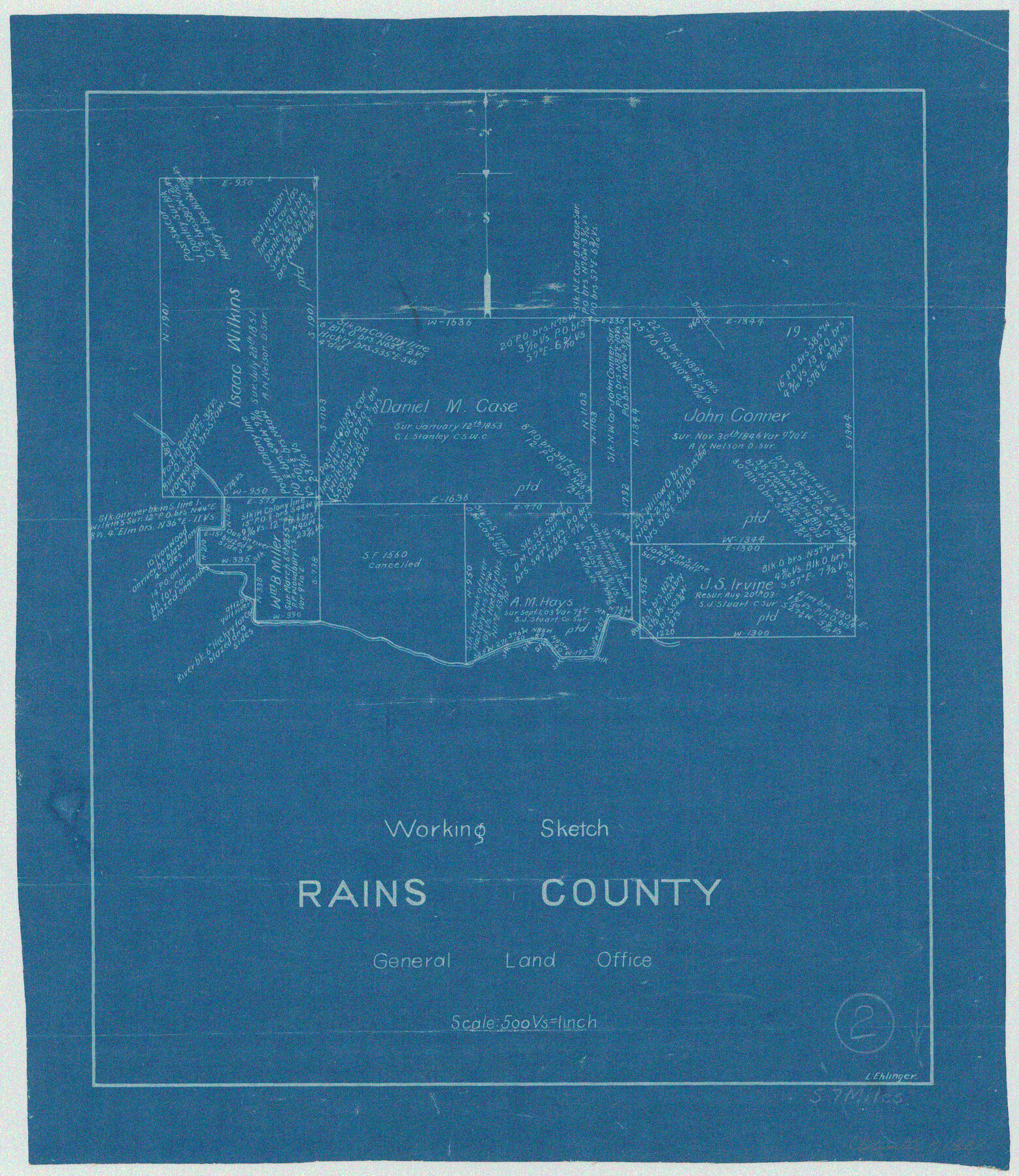
Rains County Working Sketch 2
-
Map/Doc
71828
-
Collection
General Map Collection
-
People and Organizations
L. Ehlinger (Draftsman)
-
Counties
Rains
-
Subjects
Surveying Working Sketch
-
Height x Width
14.0 x 12.2 inches
35.6 x 31.0 cm
-
Scale
1" = 500 varas
Part of: General Map Collection
Erath County Sketch File A2

Print $20.00
- Digital $50.00
Erath County Sketch File A2
Size 15.9 x 19.5 inches
Map/Doc 11464
Stonewall County Boundary File 4b

Print $18.00
- Digital $50.00
Stonewall County Boundary File 4b
Size 9.1 x 8.8 inches
Map/Doc 58993
Lamb County Sketch File B

Print $6.00
- Digital $50.00
Lamb County Sketch File B
1902
Size 11.2 x 8.8 inches
Map/Doc 29344
Brown County Sketch File 30

Print $27.00
- Digital $50.00
Brown County Sketch File 30
1924
Size 12.7 x 11.0 inches
Map/Doc 16631
Fisher County Sketch File 6a

Print $20.00
- Digital $50.00
Fisher County Sketch File 6a
Size 21.3 x 18.1 inches
Map/Doc 11476
Le Nouveau Mexique avec la partie Septentrionale de l'Ancien ou de la Nouvelle Espagne

Print $20.00
- Digital $50.00
Le Nouveau Mexique avec la partie Septentrionale de l'Ancien ou de la Nouvelle Espagne
1780
Size 10.0 x 14.4 inches
Map/Doc 97277
Texas Coordinate File 3

Print $40.00
- Digital $50.00
Texas Coordinate File 3
Size 36.1 x 49.1 inches
Map/Doc 75306
Newton County Working Sketch 32

Print $20.00
- Digital $50.00
Newton County Working Sketch 32
1955
Size 22.9 x 24.0 inches
Map/Doc 71278
Nueces County NRC Article 33.136 Sketch 17

Print $26.00
- Digital $50.00
Nueces County NRC Article 33.136 Sketch 17
2013
Size 18.0 x 24.0 inches
Map/Doc 94487
[Map of Block 97, Borden and Scurry Co (Exhibit A); Map of Southeastern part of Young Territory; Map of part of of Borden, Fisher, Kent, Mitchell, Scurry and Garza Cos. Showing the north boundary line of the T&P 80 mile reservation]
![65692, [Map of Block 97, Borden and Scurry Co (Exhibit A); Map of Southeastern part of Young Territory; Map of part of of Borden, Fisher, Kent, Mitchell, Scurry and Garza Cos. Showing the north boundary line of the T&P 80 mile reservation], General Map Collection](https://historictexasmaps.com/wmedia_w700/maps/65692-1.tif.jpg)
Print $20.00
- Digital $50.00
[Map of Block 97, Borden and Scurry Co (Exhibit A); Map of Southeastern part of Young Territory; Map of part of of Borden, Fisher, Kent, Mitchell, Scurry and Garza Cos. Showing the north boundary line of the T&P 80 mile reservation]
1873
Size 33.4 x 29.6 inches
Map/Doc 65692
Hunt County Sketch File 49

Print $4.00
- Digital $50.00
Hunt County Sketch File 49
1852
Size 7.3 x 8.9 inches
Map/Doc 27168
Flight Mission No. CRC-3R, Frame 211, Chambers County

Print $20.00
- Digital $50.00
Flight Mission No. CRC-3R, Frame 211, Chambers County
1956
Size 18.6 x 22.2 inches
Map/Doc 84866
You may also like
Map of Zapata County

Print $20.00
- Digital $50.00
Map of Zapata County
1863
Size 35.0 x 28.0 inches
Map/Doc 4175
Flight Mission No. BRA-7M, Frame 132, Jefferson County

Print $20.00
- Digital $50.00
Flight Mission No. BRA-7M, Frame 132, Jefferson County
1953
Size 18.5 x 19.6 inches
Map/Doc 85526
Hudspeth County Rolled Sketch 77

Print $20.00
- Digital $50.00
Hudspeth County Rolled Sketch 77
Size 25.2 x 38.0 inches
Map/Doc 6265
Knox County Boundary File 104

Print $10.00
- Digital $50.00
Knox County Boundary File 104
Size 9.2 x 7.4 inches
Map/Doc 65051
Flight Mission No. DCL-6C, Frame 123, Kenedy County

Print $20.00
- Digital $50.00
Flight Mission No. DCL-6C, Frame 123, Kenedy County
1943
Size 18.6 x 22.3 inches
Map/Doc 85953
Mason County Sketch File 1

Print $6.00
- Digital $50.00
Mason County Sketch File 1
1857
Size 11.0 x 8.2 inches
Map/Doc 30677
Gregg County Working Sketch 16

Print $20.00
- Digital $50.00
Gregg County Working Sketch 16
1944
Size 14.8 x 27.9 inches
Map/Doc 63283
General Highway Map, Andrews County, Gaines County, Texas

Print $20.00
General Highway Map, Andrews County, Gaines County, Texas
1940
Size 24.9 x 18.4 inches
Map/Doc 79002
[Surveys in Austin's Colony along the Brazos River and Oyster Creek]
![206, [Surveys in Austin's Colony along the Brazos River and Oyster Creek], General Map Collection](https://historictexasmaps.com/wmedia_w700/maps/206.tif.jpg)
Print $20.00
- Digital $50.00
[Surveys in Austin's Colony along the Brazos River and Oyster Creek]
1824
Size 23.1 x 17.2 inches
Map/Doc 206
Palo Pinto County

Print $20.00
- Digital $50.00
Palo Pinto County
1879
Size 24.8 x 18.4 inches
Map/Doc 3934
Karnes County Sketch File 4

Print $8.00
- Digital $50.00
Karnes County Sketch File 4
1852
Size 5.5 x 6.8 inches
Map/Doc 28550
Hudspeth County Working Sketch 21

Print $20.00
- Digital $50.00
Hudspeth County Working Sketch 21
1966
Size 22.8 x 41.6 inches
Map/Doc 66303