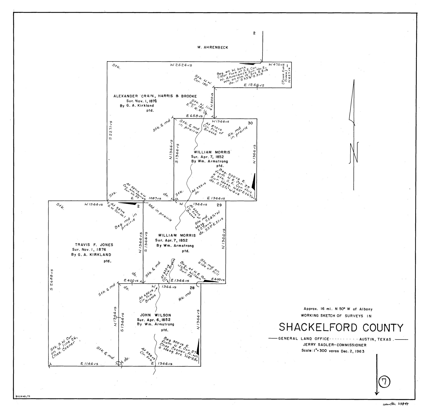
Shackelford County Working Sketch 7
-
Map/Doc
63847
-
Collection
General Map Collection
-
Object Dates
12/2/1963 (Creation Date)
-
People and Organizations
Roy Buckholts (Draftsman)
-
Counties
Shackelford
-
Subjects
Surveying Working Sketch
-
Height x Width
22.4 x 23.3 inches
56.9 x 59.2 cm
-
Scale
1" = 300 varas
Part of: General Map Collection
Marion County Sketch File 1a

Print $3.00
- Digital $50.00
Marion County Sketch File 1a
1867
Size 17.4 x 7.7 inches
Map/Doc 30559
Wood County Boundary File 4

Print $6.00
- Digital $50.00
Wood County Boundary File 4
Size 12.1 x 8.1 inches
Map/Doc 60167
El Paso County Working Sketch 7

Print $20.00
- Digital $50.00
El Paso County Working Sketch 7
1928
Size 25.7 x 16.9 inches
Map/Doc 69029
Flight Mission No. CLL-3N, Frame 40, Willacy County

Print $20.00
- Digital $50.00
Flight Mission No. CLL-3N, Frame 40, Willacy County
1954
Size 18.3 x 22.0 inches
Map/Doc 87098
Wilbarger County Sketch File 26

Print $4.00
- Digital $50.00
Wilbarger County Sketch File 26
1885
Size 14.3 x 8.6 inches
Map/Doc 40227
Red River County Sketch File 15

Print $4.00
- Digital $50.00
Red River County Sketch File 15
1863
Size 12.1 x 7.2 inches
Map/Doc 35137

Houston County Sketch File 6

Print $4.00
- Digital $50.00
Houston County Sketch File 6
1857
Size 12.0 x 4.7 inches
Map/Doc 26760
Travis County Boundary File 25

Print $8.00
- Digital $50.00
Travis County Boundary File 25
Size 9.0 x 6.4 inches
Map/Doc 59459
Howard County Rolled Sketch 2

Print $20.00
- Digital $50.00
Howard County Rolled Sketch 2
1905
Size 27.6 x 23.0 inches
Map/Doc 6232
Cooke County Working Sketch 24

Print $20.00
- Digital $50.00
Cooke County Working Sketch 24
1972
Size 22.1 x 24.4 inches
Map/Doc 68261
San Patricio County Working Sketch Graphic Index

Print $20.00
- Digital $50.00
San Patricio County Working Sketch Graphic Index
1939
Size 36.6 x 47.9 inches
Map/Doc 76692
You may also like
Hardeman County Sketch File 4

Print $6.00
- Digital $50.00
Hardeman County Sketch File 4
Size 9.3 x 8.2 inches
Map/Doc 24991
Montgomery County Working Sketch 46

Print $20.00
- Digital $50.00
Montgomery County Working Sketch 46
1957
Size 25.6 x 28.1 inches
Map/Doc 71153
Kinney County Sketch File 16a

Print $40.00
- Digital $50.00
Kinney County Sketch File 16a
Size 12.8 x 16.0 inches
Map/Doc 29133
San Patricio County Rolled Sketch 21

Print $20.00
- Digital $50.00
San Patricio County Rolled Sketch 21
1935
Size 25.9 x 24.7 inches
Map/Doc 7580

Flight Mission No. DQN-1K, Frame 125, Calhoun County

Print $20.00
- Digital $50.00
Flight Mission No. DQN-1K, Frame 125, Calhoun County
1953
Size 18.4 x 22.1 inches
Map/Doc 84191
Right of Way and Track Map of The Missouri, Kansas & Texas Railway of Texas

Print $40.00
- Digital $50.00
Right of Way and Track Map of The Missouri, Kansas & Texas Railway of Texas
1918
Size 25.2 x 106.9 inches
Map/Doc 64531
Val Verde County Rolled Sketch 61

Print $20.00
- Digital $50.00
Val Verde County Rolled Sketch 61
1938
Size 27.3 x 24.2 inches
Map/Doc 8128
[Map showing T&P Lands in El Paso County]
![88931, [Map showing T&P Lands in El Paso County], Library of Congress](https://historictexasmaps.com/wmedia_w700/maps/88931.tif.jpg)
Print $20.00
[Map showing T&P Lands in El Paso County]
Size 22.4 x 17.3 inches
Map/Doc 88931
United States - Gulf Coast Texas - Southern part of Laguna Madre

Print $20.00
- Digital $50.00
United States - Gulf Coast Texas - Southern part of Laguna Madre
1941
Size 26.5 x 18.3 inches
Map/Doc 72955
The Republic County of Liberty. Spring 1842

Print $20.00
The Republic County of Liberty. Spring 1842
2020
Size 19.9 x 21.7 inches
Map/Doc 96212
Presidio County Rolled Sketch 87

Print $20.00
- Digital $50.00
Presidio County Rolled Sketch 87
Size 26.4 x 38.2 inches
Map/Doc 7373