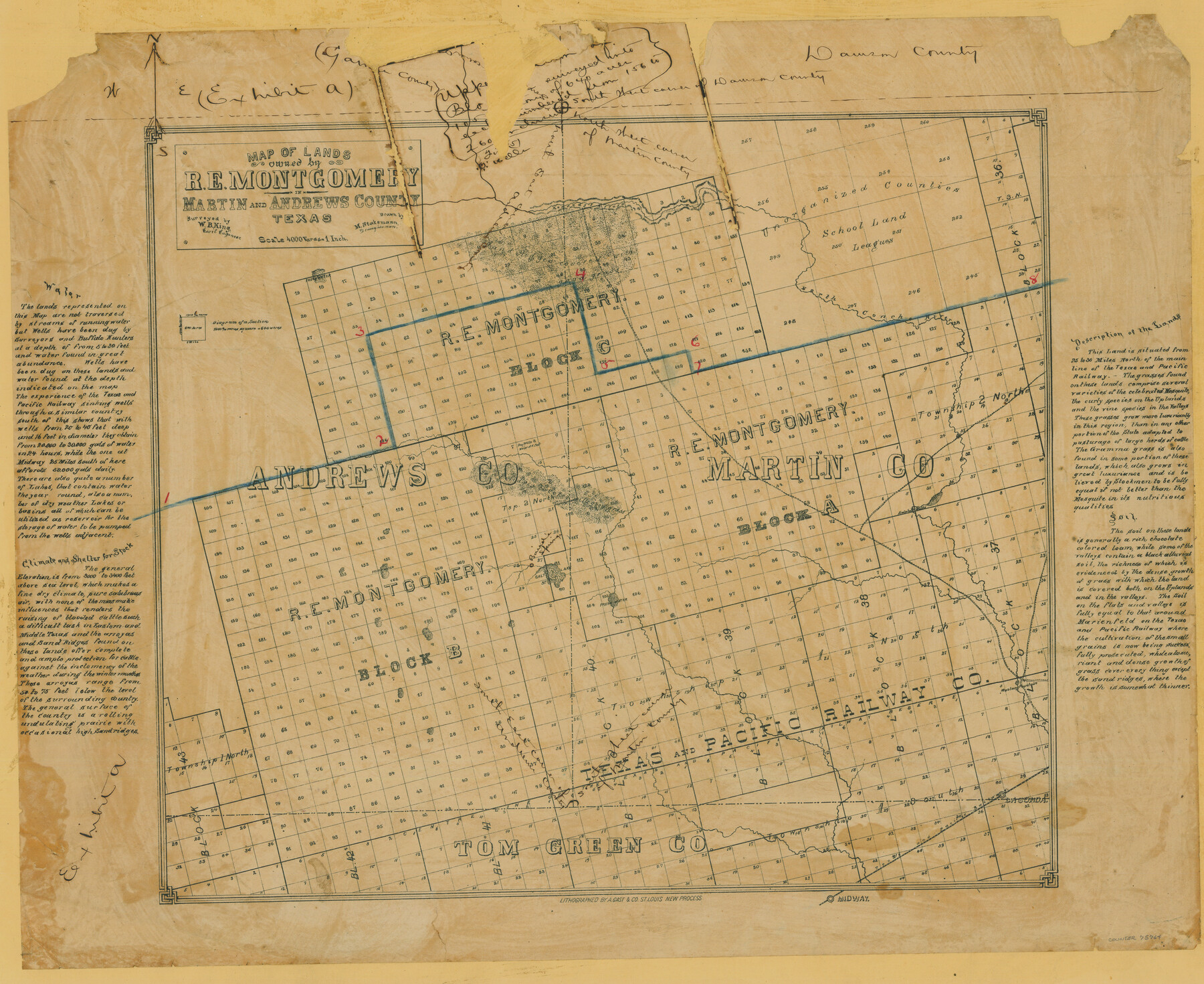
Map of lands owned by R.E. Montgomery in Martin and Andrews County, Texas
-
Map/Doc
75764
-
Collection
Maddox Collection
-
People and Organizations
M. Stakemann (Draftsman)
W.B. King (Surveyor/Engineer)
August Gast & Co. (Lithographer)
-
Counties
Andrews Martin Tom Green Ector Midland
-
Height x Width
20.0 x 24.5 inches
50.8 x 62.2 cm
-
Medium
paper, etching/engraving/lithograph
-
Scale
1" = 4000 varas
-
Comments
The map reflects Tom Green county, but the county lines have changed and currently that area is in Ector and Midland counties.
Includes handwritten text and notes.
"Lithographed by A. Gast & Co. St. Louis new process" -
Features
Kennedy's Arroyo
North Concho River
Mustang Fountain
Sulphur Wells
T&P
Baird's Springs
La Conda
Midway
Part of: Maddox Collection
[Sketch Showing Surveys Adjacent to Richmond, Fort Bend County, Texas]
![395, [Sketch Showing Surveys Adjacent to Richmond, Fort Bend County, Texas], Maddox Collection](https://historictexasmaps.com/wmedia_w700/maps/0395.tif.jpg)
Print $2.00
- Digital $50.00
[Sketch Showing Surveys Adjacent to Richmond, Fort Bend County, Texas]
Size 9.9 x 7.7 inches
Map/Doc 395
Map of a resurvey of the land involved in the suit of Lillian-Vineyard vs. O.M. O'Connor et al (Lamar townlots excepted)

Print $20.00
- Digital $50.00
Map of a resurvey of the land involved in the suit of Lillian-Vineyard vs. O.M. O'Connor et al (Lamar townlots excepted)
1911
Size 18.8 x 17.9 inches
Map/Doc 481
Map of Runnels County, Texas

Print $20.00
- Digital $50.00
Map of Runnels County, Texas
1879
Size 28.8 x 22.0 inches
Map/Doc 5035
[Surveying Sketch of Kendall County School Land, et al in Kerr County, Texas]
![5072, [Surveying Sketch of Kendall County School Land, et al in Kerr County, Texas], Maddox Collection](https://historictexasmaps.com/wmedia_w700/maps/5072-1.tif.jpg)
Print $3.00
- Digital $50.00
[Surveying Sketch of Kendall County School Land, et al in Kerr County, Texas]
Size 11.9 x 12.9 inches
Map/Doc 5072
Saline Ranch in Mason, Kimble and Menard Counties

Print $20.00
- Digital $50.00
Saline Ranch in Mason, Kimble and Menard Counties
1916
Size 28.6 x 27.4 inches
Map/Doc 75808
[Sketch of surveys north of "Las Animas" grant, Webb County]
![668, [Sketch of surveys north of "Las Animas" grant, Webb County], Maddox Collection](https://historictexasmaps.com/wmedia_w700/maps/668.tif.jpg)
Print $3.00
- Digital $50.00
[Sketch of surveys north of "Las Animas" grant, Webb County]
1908
Size 16.9 x 10.7 inches
Map/Doc 668
[Wm. B. Jaques assee. of José Pineda, Kimble County, Texas]
![540, [Wm. B. Jaques assee. of José Pineda, Kimble County, Texas], Maddox Collection](https://historictexasmaps.com/wmedia_w700/maps/0540.tif.jpg)
Print $3.00
- Digital $50.00
[Wm. B. Jaques assee. of José Pineda, Kimble County, Texas]
Size 16.1 x 11.2 inches
Map/Doc 540
Red River County, Texas

Print $20.00
- Digital $50.00
Red River County, Texas
1879
Size 29.3 x 21.9 inches
Map/Doc 598
Bosque County, Texas

Print $20.00
- Digital $50.00
Bosque County, Texas
1879
Size 25.1 x 29.9 inches
Map/Doc 420
[Sketch of San Antonio del Encinal, Hidalgo County, Texas]
![4457, [Sketch of San Antonio del Encinal, Hidalgo County, Texas], Maddox Collection](https://historictexasmaps.com/wmedia_w700/maps/4457-1.tif.jpg)
Print $20.00
- Digital $50.00
[Sketch of San Antonio del Encinal, Hidalgo County, Texas]
Size 12.1 x 27.1 inches
Map/Doc 4457
Sketch X, Hardin County

Print $20.00
- Digital $50.00
Sketch X, Hardin County
1904
Size 26.3 x 38.1 inches
Map/Doc 75823
Map of West Part of Galveston County, Texas

Print $20.00
- Digital $50.00
Map of West Part of Galveston County, Texas
1880
Size 28.6 x 21.9 inches
Map/Doc 716
You may also like
Zapata County Rolled Sketch 12A

Print $40.00
- Digital $50.00
Zapata County Rolled Sketch 12A
1917
Size 54.0 x 40.0 inches
Map/Doc 10165
Travis County Appraisal District Plat Map 2_0502

Print $20.00
- Digital $50.00
Travis County Appraisal District Plat Map 2_0502
Size 21.4 x 26.4 inches
Map/Doc 94236
Kent County Rolled Sketch 2

Print $20.00
- Digital $50.00
Kent County Rolled Sketch 2
1950
Size 22.6 x 40.8 inches
Map/Doc 6473
Flight Mission No. BRA-6M, Frame 142, Jefferson County

Print $20.00
- Digital $50.00
Flight Mission No. BRA-6M, Frame 142, Jefferson County
1953
Size 18.6 x 22.3 inches
Map/Doc 85443
Flight Mission No. DAG-2T, Frame 101, Matagorda County

Print $20.00
- Digital $50.00
Flight Mission No. DAG-2T, Frame 101, Matagorda County
1957
Size 18.6 x 18.3 inches
Map/Doc 86444
Capitol Syndicate Subdivision of Capitol Land Reservation Leagues Number 153, 154, 155, 156, 157, 158, 167, 168, 169, 170, 171, and 172 and Parts of Leagues 143, 144, 145, 146, 152, 159, 166, and 173

Print $20.00
- Digital $50.00
Capitol Syndicate Subdivision of Capitol Land Reservation Leagues Number 153, 154, 155, 156, 157, 158, 167, 168, 169, 170, 171, and 172 and Parts of Leagues 143, 144, 145, 146, 152, 159, 166, and 173
1908
Size 22.8 x 34.6 inches
Map/Doc 90735
Flight Mission No. CGI-4N, Frame 21, Cameron County

Print $20.00
- Digital $50.00
Flight Mission No. CGI-4N, Frame 21, Cameron County
1954
Size 18.5 x 22.2 inches
Map/Doc 84654
Karnes County Working Sketch 3

Print $20.00
- Digital $50.00
Karnes County Working Sketch 3
1943
Size 34.6 x 31.4 inches
Map/Doc 66651
Upton County Sketch File 43

Print $22.00
- Digital $50.00
Upton County Sketch File 43
1988
Size 11.4 x 8.8 inches
Map/Doc 38920
Presidio County Rolled Sketch 102

Print $20.00
- Digital $50.00
Presidio County Rolled Sketch 102
1957
Size 19.3 x 13.8 inches
Map/Doc 7385
Crosby County Sketch File 14a

Print $40.00
- Digital $50.00
Crosby County Sketch File 14a
Size 18.9 x 20.5 inches
Map/Doc 11249
Hudspeth County Working Sketch 56

Print $20.00
- Digital $50.00
Hudspeth County Working Sketch 56
1992
Size 40.7 x 31.1 inches
Map/Doc 66341