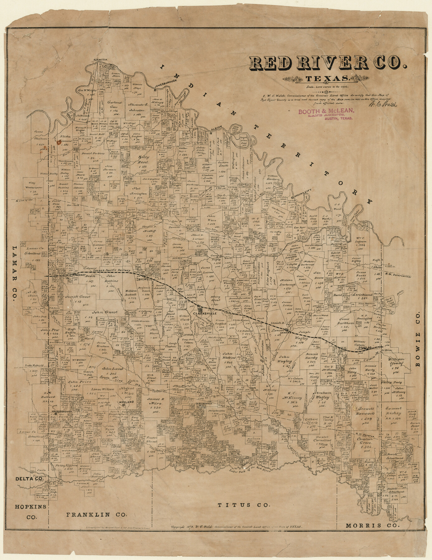
Red River County, Texas
-
Map/Doc
598
-
Collection
Maddox Collection
-
Object Dates
1879 (Creation Date)
-
People and Organizations
General Land Office (Publisher)
W.C. Walsh (GLO Commissioner)
August Gast & Co. (Lithographer)
-
Counties
Red River
-
Subjects
County
-
Height x Width
29.3 x 21.9 inches
74.4 x 55.6 cm
-
Medium
paper, etching/engraving/lithograph
-
Scale
1" = 4000 varas
-
Comments
Conservation funded in 2011 by Friends of the Texas General Land Office.
-
Features
Halesborough
Kicapoo [sic] Creek
Douglas
Shawney [sic] Village Creek
Heeltop Creek
Garvinsville
White Oak Creek
Slapham Creek
Baggy Creek
Cuthand Creek
Wayland
Annona
Big Mustang Creek
Little Mustang Creek
Maple Creek
Big Slough
Elm Creek
Caney Creek
Shawney [sic] Lake
Sulfur Fork of the Red River
Brushy Creek
Cedar Creek
White Oak Fork [of Pecan Bayou]
Jonesborough
Hasted's Lake
Pine Creek
Albion
Slingland Lake
Mound City
Mill Creek
Little Pine Creek
North Fork [of Pecan Bayou]
Pecan Bayou
Kiamitia
Little Creek
Clarksville
Bagwell
Bennet
Guest Creek
Cat Creek
Ward Creek
Bruton Creek
Bland Creek
Grugg Creek
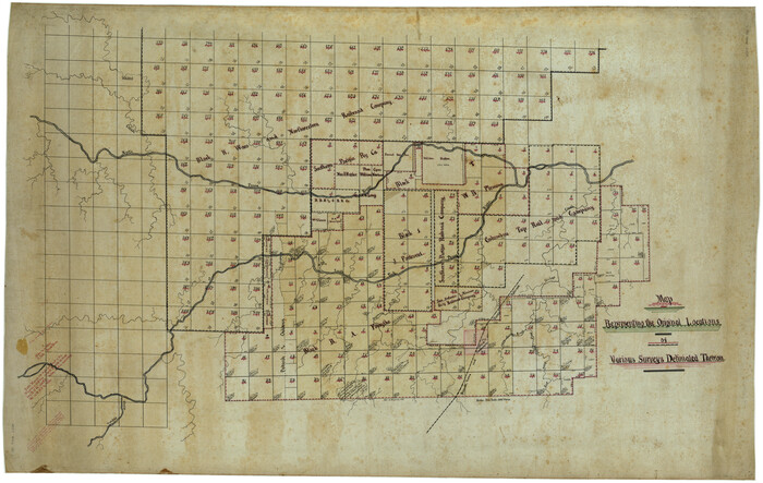
Part of: Maddox Collection
Map Representing the Original Locations of Various Surveys Deliniated Thereon
Print $40.00
- Digital $50.00
Map Representing the Original Locations of Various Surveys Deliniated Thereon
1890
Size 40.8 x 62.0 inches
Map/Doc 469
Working Sketch in Dickens and Crosby Cos.

Print $20.00
- Digital $50.00
Working Sketch in Dickens and Crosby Cos.
1910
Size 36.1 x 24.8 inches
Map/Doc 10771
Lynn County, Texas

Print $20.00
- Digital $50.00
Lynn County, Texas
1883
Size 19.0 x 18.3 inches
Map/Doc 739
[Sketch of Plans and Bill of Material for 38' x 40' Texas Highway Dept. Warehouse]
![450, [Sketch of Plans and Bill of Material for 38' x 40' Texas Highway Dept. Warehouse], Maddox Collection](https://historictexasmaps.com/wmedia_w700/maps/450.tif.jpg)
Print $20.00
- Digital $50.00
[Sketch of Plans and Bill of Material for 38' x 40' Texas Highway Dept. Warehouse]
Size 23.7 x 22.8 inches
Map/Doc 450
Victoria County, Texas

Print $20.00
- Digital $50.00
Victoria County, Texas
1879
Size 26.5 x 22.8 inches
Map/Doc 511
Map Showing Survey and Subdivision of the Wendlandt Property in Outlot 4, Division "Z"

Print $3.00
- Digital $50.00
Map Showing Survey and Subdivision of the Wendlandt Property in Outlot 4, Division "Z"
1910
Size 10.8 x 17.7 inches
Map/Doc 508
Haskell County

Print $20.00
- Digital $50.00
Haskell County
1888
Size 41.4 x 33.9 inches
Map/Doc 399
Wendlandt's Subdivision of part of Outlot 4, Division "Z"

Print $20.00
- Digital $50.00
Wendlandt's Subdivision of part of Outlot 4, Division "Z"
1910
Size 18.0 x 13.6 inches
Map/Doc 83428
Survey in South Austin for Mr. R.N. Graham

Print $20.00
- Digital $50.00
Survey in South Austin for Mr. R.N. Graham
Map/Doc 93795
Map of Colorado County, Texas

Print $20.00
- Digital $50.00
Map of Colorado County, Texas
Size 28.6 x 23.5 inches
Map/Doc 700
Sketch of Block B, GH & H RR & Blk C, CT RR Co, with surrounding & conflicting surveys in Knox & Baylor Counties

Print $20.00
- Digital $50.00
Sketch of Block B, GH & H RR & Blk C, CT RR Co, with surrounding & conflicting surveys in Knox & Baylor Counties
Size 24.9 x 17.9 inches
Map/Doc 75784
[Sketch Showing G. H. & H. R.R. Co. Block 3B and A. B. & M. Block M16, Hutchinson County, Texas]
![75813, [Sketch Showing G. H. & H. R.R. Co. Block 3B and A. B. & M. Block M16, Hutchinson County, Texas], Maddox Collection](https://historictexasmaps.com/wmedia_w700/maps/75813.tif.jpg)
Print $20.00
- Digital $50.00
[Sketch Showing G. H. & H. R.R. Co. Block 3B and A. B. & M. Block M16, Hutchinson County, Texas]
Size 20.7 x 21.5 inches
Map/Doc 75813
You may also like
Map of Mason County

Print $20.00
- Digital $50.00
Map of Mason County
1879
Size 22.9 x 18.8 inches
Map/Doc 4593
West Part of Liberty Co.

Print $20.00
- Digital $50.00
West Part of Liberty Co.
1977
Size 43.5 x 32.9 inches
Map/Doc 77353
Flight Mission No. DIX-10P, Frame 78, Aransas County

Print $20.00
- Digital $50.00
Flight Mission No. DIX-10P, Frame 78, Aransas County
1956
Size 18.8 x 22.4 inches
Map/Doc 83939
Outer Continental Shelf Leasing Maps (Louisiana Offshore Operations)

Print $20.00
- Digital $50.00
Outer Continental Shelf Leasing Maps (Louisiana Offshore Operations)
1954
Size 21.2 x 16.3 inches
Map/Doc 76103
Map of Independence Area, Washington County, Texas

Print $20.00
- Digital $50.00
Map of Independence Area, Washington County, Texas
1935
Size 24.0 x 19.1 inches
Map/Doc 91989
Nautical Chart 885-SC Intracoastal Waterway - Ellender to Galveston Bay, Louisiana-Texas

Print $40.00
- Digital $50.00
Nautical Chart 885-SC Intracoastal Waterway - Ellender to Galveston Bay, Louisiana-Texas
1972
Size 16.4 x 60.1 inches
Map/Doc 69835
Intracoastal Waterway - Gibbstown to Port Arthur

Print $20.00
- Digital $50.00
Intracoastal Waterway - Gibbstown to Port Arthur
1957
Size 27.1 x 38.8 inches
Map/Doc 69829
Cass County Working Sketch 19

Print $20.00
- Digital $50.00
Cass County Working Sketch 19
1959
Size 27.2 x 29.3 inches
Map/Doc 67922
Van Zandt County Sketch File 39

Print $6.00
- Digital $50.00
Van Zandt County Sketch File 39
1871
Size 10.8 x 13.4 inches
Map/Doc 39484
Flight Mission No. CRC-1R, Frame 39, Chambers County

Print $20.00
- Digital $50.00
Flight Mission No. CRC-1R, Frame 39, Chambers County
1956
Size 18.8 x 22.4 inches
Map/Doc 84707
Trinity County Sketch File 5b

Print $4.00
- Digital $50.00
Trinity County Sketch File 5b
1855
Size 12.6 x 8.0 inches
Map/Doc 38506
Right of Way and Track Map International & Gt Northern Ry. operated by the International & Gt. Northern Ry. Co., San Antonio Division

Print $40.00
- Digital $50.00
Right of Way and Track Map International & Gt Northern Ry. operated by the International & Gt. Northern Ry. Co., San Antonio Division
1917
Size 25.7 x 63.1 inches
Map/Doc 64586