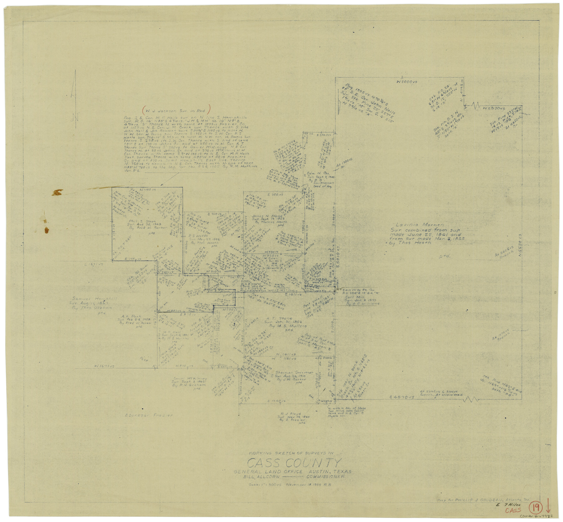
Cass County Working Sketch 19
-
Map/Doc
67922
-
Collection
General Map Collection
-
Object Dates
11/18/1959 (Creation Date)
-
Counties
Cass
-
Subjects
Surveying Working Sketch
-
Height x Width
27.2 x 29.3 inches
69.1 x 74.4 cm
-
Scale
1" = 300 varas
Part of: General Map Collection
King County Sketch File 10

Print $24.00
- Digital $50.00
King County Sketch File 10
1902
Size 14.2 x 8.7 inches
Map/Doc 29083
Map of the upper surveys in Robertson's Colony Sold by the State of Coahuila and Texas

Print $20.00
- Digital $50.00
Map of the upper surveys in Robertson's Colony Sold by the State of Coahuila and Texas
Size 26.8 x 22.0 inches
Map/Doc 82
Hudspeth County Rolled Sketch 41

Print $40.00
- Digital $50.00
Hudspeth County Rolled Sketch 41
1947
Size 11.3 x 96.3 inches
Map/Doc 9214
Zavala County Sketch File 46

Print $20.00
- Digital $50.00
Zavala County Sketch File 46
1937
Size 16.7 x 18.8 inches
Map/Doc 12734
Lamb County Sketch File 13

Print $42.00
- Digital $50.00
Lamb County Sketch File 13
1914
Size 9.1 x 8.6 inches
Map/Doc 29371
Liberty County Sketch File 54

Print $54.00
- Digital $50.00
Liberty County Sketch File 54
1889
Size 14.3 x 8.7 inches
Map/Doc 30022
Hudspeth County Sketch File 52

Print $100.00
- Digital $50.00
Hudspeth County Sketch File 52
1983
Size 10.9 x 31.2 inches
Map/Doc 11807
Flight Mission No. CGI-3N, Frame 103, Cameron County

Print $20.00
- Digital $50.00
Flight Mission No. CGI-3N, Frame 103, Cameron County
1954
Size 18.4 x 22.2 inches
Map/Doc 84583
Zavala County Sketch File 1

Print $20.00
- Digital $50.00
Zavala County Sketch File 1
Size 28.5 x 22.7 inches
Map/Doc 12725

Wharton County Working Sketch 18

Print $20.00
- Digital $50.00
Wharton County Working Sketch 18
1948
Size 19.3 x 17.0 inches
Map/Doc 72482
Galveston County Sketch File 33

Print $12.00
- Digital $50.00
Galveston County Sketch File 33
1934
Size 11.2 x 8.8 inches
Map/Doc 23413
You may also like
[School Leagues 245-260, 320-322, 325]
![91342, [School Leagues 245-260, 320-322, 325], Twichell Survey Records](https://historictexasmaps.com/wmedia_w700/maps/91342-1.tif.jpg)
Print $20.00
- Digital $50.00
[School Leagues 245-260, 320-322, 325]
Size 23.3 x 41.4 inches
Map/Doc 91342
Anderson County Sketch File 25

Print $40.00
- Digital $50.00
Anderson County Sketch File 25
1969
Size 40.9 x 21.9 inches
Map/Doc 10316
[T. & P. Blocks 33 and 34, Townships 4N and 5N]
![90625, [T. & P. Blocks 33 and 34, Townships 4N and 5N], Twichell Survey Records](https://historictexasmaps.com/wmedia_w700/maps/90625-1.tif.jpg)
Print $20.00
- Digital $50.00
[T. & P. Blocks 33 and 34, Townships 4N and 5N]
Size 14.4 x 17.7 inches
Map/Doc 90625
[Letters to and from Maj. W. J. Powell regarding surveys of Texas and Pacific Ry. Lands west of the Pecos. Blks 53-55, Township 1 & 2 map within]
![2249, [Letters to and from Maj. W. J. Powell regarding surveys of Texas and Pacific Ry. Lands west of the Pecos. Blks 53-55, Township 1 & 2 map within], General Map Collection](https://historictexasmaps.com/wmedia_w700/pdf_converted_jpg/qi_pdf_thumbnail_1039.jpg)
Print $124.00
- Digital $50.00
[Letters to and from Maj. W. J. Powell regarding surveys of Texas and Pacific Ry. Lands west of the Pecos. Blks 53-55, Township 1 & 2 map within]
1934
Size 10.2 x 15.4 inches
Map/Doc 2249
Knox County Rolled Sketch 15

Print $40.00
- Digital $50.00
Knox County Rolled Sketch 15
1892
Size 21.9 x 54.8 inches
Map/Doc 10667
[Surveying Sketch of W.B. Tatum, Wm. B. Jordan, et al]
![428, [Surveying Sketch of W.B. Tatum, Wm. B. Jordan, et al], Maddox Collection](https://historictexasmaps.com/wmedia_w700/maps/0428.tif.jpg)
Print $2.00
- Digital $50.00
[Surveying Sketch of W.B. Tatum, Wm. B. Jordan, et al]
Size 8.9 x 10.8 inches
Map/Doc 428
[Worksheets related to the Wilson Strickland survey and vicinity]
![89715, [Vicinity and related to the Wilson Strickland Survey], Twichell Survey Records](https://historictexasmaps.com/wmedia_w700/maps/89715-1.tif.jpg)
Print $20.00
- Digital $50.00
[Worksheets related to the Wilson Strickland survey and vicinity]
Size 34.7 x 43.0 inches
Map/Doc 89715

Dallas County Boundary File 2

Print $10.00
- Digital $50.00
Dallas County Boundary File 2
Size 11.2 x 8.4 inches
Map/Doc 52115
Map of Harris County

Print $40.00
- Digital $50.00
Map of Harris County
1897
Size 48.4 x 66.9 inches
Map/Doc 82068
Flight Mission No. CRC-3R, Frame 33, Chambers County

Print $20.00
- Digital $50.00
Flight Mission No. CRC-3R, Frame 33, Chambers County
1956
Size 18.6 x 22.4 inches
Map/Doc 84806
[Leagues 218- 236]
![91454, [Leagues 218- 236], Twichell Survey Records](https://historictexasmaps.com/wmedia_w700/maps/91454-1.tif.jpg)
Print $2.00
- Digital $50.00
[Leagues 218- 236]
Size 7.0 x 11.6 inches
Map/Doc 91454