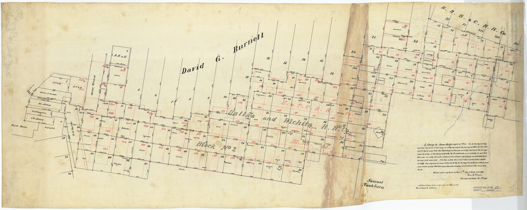
Knox County Rolled Sketch 15
[Sketch of Dallas and Wichita R.R. Co. Block 2 and surrounding area]
-
Map/Doc
10667
-
Collection
General Map Collection
-
Object Dates
1892/5/11 (Creation Date)
-
People and Organizations
George L. Crum (Surveyor/Engineer)
-
Counties
Knox
-
Subjects
Surveying Rolled Sketch
-
Height x Width
21.9 x 54.8 inches
55.6 x 139.2 cm
-
Medium
linen, manuscript
Part of: General Map Collection
Val Verde County Working Sketch 18

Print $20.00
- Digital $50.00
Val Verde County Working Sketch 18
1928
Size 31.4 x 28.3 inches
Map/Doc 72153
Hardin County Sketch File 8

Print $8.00
- Digital $50.00
Hardin County Sketch File 8
1870
Size 12.6 x 8.1 inches
Map/Doc 25102
Angelina County

Print $40.00
- Digital $50.00
Angelina County
1945
Size 39.0 x 48.4 inches
Map/Doc 73068
Flight Mission No. CGI-4N, Frame 189, Cameron County

Print $20.00
- Digital $50.00
Flight Mission No. CGI-4N, Frame 189, Cameron County
1955
Size 18.5 x 22.2 inches
Map/Doc 84692
[Plat of Trinity River w/ Midstream Profile in Liberty County by US Government 1899]
![65340, [Plat of Trinity River w/ Midstream Profile in Liberty County by US Government 1899], General Map Collection](https://historictexasmaps.com/wmedia_w700/maps/65340.tif.jpg)
Print $20.00
- Digital $50.00
[Plat of Trinity River w/ Midstream Profile in Liberty County by US Government 1899]
1899
Size 12.8 x 18.2 inches
Map/Doc 65340
Gulf Intracoastal Waterway - Aransas Bay to Corpus Christi Bay - Modified Route Main Channel

Print $20.00
- Digital $50.00
Gulf Intracoastal Waterway - Aransas Bay to Corpus Christi Bay - Modified Route Main Channel
1960
Size 31.0 x 42.7 inches
Map/Doc 61901
San Patricio County NRC Article 33.136 Location Key Sheet

Print $20.00
- Digital $50.00
San Patricio County NRC Article 33.136 Location Key Sheet
1975
Size 27.0 x 23.0 inches
Map/Doc 77035
Jasper County Working Sketch 24

Print $40.00
- Digital $50.00
Jasper County Working Sketch 24
1948
Size 46.9 x 56.2 inches
Map/Doc 66486
Baylor County Boundary File 15

Print $4.00
- Digital $50.00
Baylor County Boundary File 15
Size 10.1 x 8.0 inches
Map/Doc 50431
Real County Working Sketch 8

Print $20.00
- Digital $50.00
Real County Working Sketch 8
1928
Size 38.1 x 44.3 inches
Map/Doc 71900
J No. 9 - Reconnaissance of the Western Coast of the United States from San Francisco to San Diego

Print $20.00
- Digital $50.00
J No. 9 - Reconnaissance of the Western Coast of the United States from San Francisco to San Diego
1852
Size 24.5 x 24.4 inches
Map/Doc 97236
Brazoria County NRC Article 33.136 Sketch 8

Print $20.00
- Digital $50.00
Brazoria County NRC Article 33.136 Sketch 8
2006
Size 17.1 x 11.2 inches
Map/Doc 83649
You may also like
Chambers County NRC Article 33.136 Sketch 15

Print $62.00
Chambers County NRC Article 33.136 Sketch 15
2025
Map/Doc 97510
Hale County Working Sketch 3

Print $20.00
- Digital $50.00
Hale County Working Sketch 3
1963
Size 27.0 x 22.2 inches
Map/Doc 63323
General Highway Map Lamb County, Texas

Print $20.00
- Digital $50.00
General Highway Map Lamb County, Texas
1949
Size 19.0 x 26.0 inches
Map/Doc 92172
Flight Mission No. BRE-2P, Frame 78, Nueces County

Print $20.00
- Digital $50.00
Flight Mission No. BRE-2P, Frame 78, Nueces County
1956
Size 18.6 x 22.3 inches
Map/Doc 86773
America's Fun-Tier: Texas 1967 Official State Highway Map

Digital $50.00
America's Fun-Tier: Texas 1967 Official State Highway Map
Size 28.3 x 36.6 inches
Map/Doc 94322
Falls County Sketch File 14

Print $40.00
- Digital $50.00
Falls County Sketch File 14
Size 15.9 x 12.9 inches
Map/Doc 22370
Aransas County Sketch File 21

Print $2.00
- Digital $50.00
Aransas County Sketch File 21
Size 8.0 x 8.9 inches
Map/Doc 13157
Montgomery County

Print $20.00
- Digital $50.00
Montgomery County
1895
Size 21.6 x 24.8 inches
Map/Doc 3897
La Salle County Rolled Sketch 18

Print $20.00
- Digital $50.00
La Salle County Rolled Sketch 18
Size 29.8 x 20.6 inches
Map/Doc 6582
Map exhibiting the lines of march passed over by the troops of the United States during the year ending June 30th, 1858 prepared by order of the Hon. J.B. Floyd, Sec. War.

Print $20.00
- Digital $50.00
Map exhibiting the lines of march passed over by the troops of the United States during the year ending June 30th, 1858 prepared by order of the Hon. J.B. Floyd, Sec. War.
1858
Size 20.0 x 20.3 inches
Map/Doc 94079

