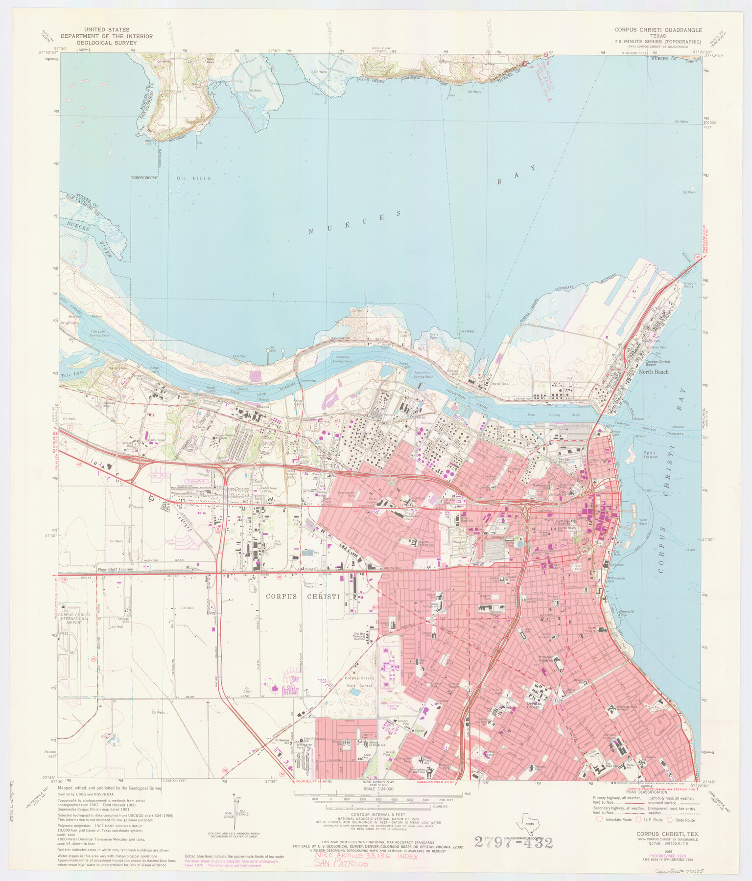
San Patricio County NRC Article 33.136 Location Key Sheet
Corpus Christi Quadrangle
-
Map/Doc
77035
-
Collection
General Map Collection
-
Object Dates
1975 (Creation Date)
-
People and Organizations
U. S. Geological Survey (Publisher)
U. S. Geological Survey (Printer)
-
Counties
San Patricio
-
Subjects
Surveying CBS
-
Height x Width
27.0 x 23.0 inches
68.6 x 58.4 cm
Part of: General Map Collection
Houston County Working Sketch 5

Print $20.00
- Digital $50.00
Houston County Working Sketch 5
Size 24.9 x 28.1 inches
Map/Doc 66235
Wilbarger County Sketch File 29

Print $18.00
- Digital $50.00
Wilbarger County Sketch File 29
2016
Size 11.0 x 8.5 inches
Map/Doc 95325
Kimble County Working Sketch 93

Print $20.00
- Digital $50.00
Kimble County Working Sketch 93
1983
Size 31.5 x 37.8 inches
Map/Doc 70161
Parker County Sketch File C

Print $4.00
- Digital $50.00
Parker County Sketch File C
1857
Size 6.1 x 7.8 inches
Map/Doc 33512
Garza County Working Sketch 4

Print $20.00
- Digital $50.00
Garza County Working Sketch 4
1916
Size 19.5 x 23.1 inches
Map/Doc 63151
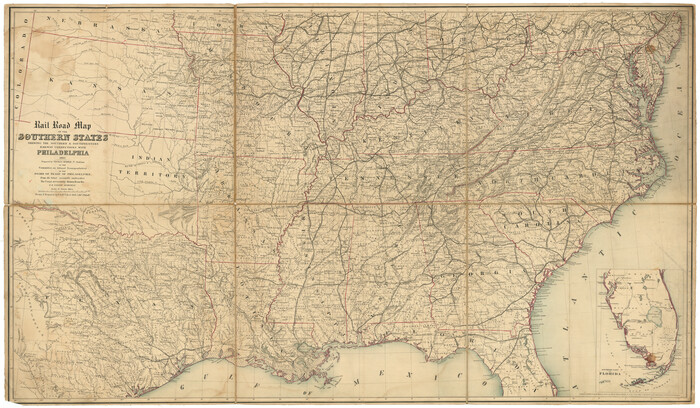
Rail Road Map of the Southern States shewing the Southern & Southwestern Railway Connections with Philadelphia
Print $40.00
- Digital $50.00
Rail Road Map of the Southern States shewing the Southern & Southwestern Railway Connections with Philadelphia
1862
Size 31.6 x 54.1 inches
Map/Doc 97482
Matagorda County Sketch File 42

Print $38.00
- Digital $50.00
Matagorda County Sketch File 42
1912
Size 14.2 x 8.8 inches
Map/Doc 30834
Map of Washington District

Print $20.00
- Digital $50.00
Map of Washington District
1847
Size 17.6 x 26.8 inches
Map/Doc 4125
Pecos County Sketch File 68

Print $6.00
- Digital $50.00
Pecos County Sketch File 68
1920
Size 14.4 x 8.8 inches
Map/Doc 33866
Kerr County Sketch File 9

Print $8.00
- Digital $50.00
Kerr County Sketch File 9
1884
Size 10.2 x 8.2 inches
Map/Doc 28873
Travis County Appraisal District Plat Map 2_1002

Print $20.00
- Digital $50.00
Travis County Appraisal District Plat Map 2_1002
Size 21.4 x 26.5 inches
Map/Doc 94230
Collin County Boundary File 4 and 4a

Print $160.00
- Digital $50.00
Collin County Boundary File 4 and 4a
Size 11.9 x 8.5 inches
Map/Doc 51691
You may also like
Refugio County Sketch File 13

Print $5.00
- Digital $50.00
Refugio County Sketch File 13
Size 8.2 x 10.3 inches
Map/Doc 35265
[I. & G. N. RR. Co. Block I]
![89828, [I. &G. N. RR. Co. Block I], Twichell Survey Records](https://historictexasmaps.com/wmedia_w700/maps/89828-1.tif.jpg)
Print $20.00
- Digital $50.00
[I. & G. N. RR. Co. Block I]
Size 43.0 x 31.7 inches
Map/Doc 89828
Ward County Rolled Sketch 24F

Print $40.00
- Digital $50.00
Ward County Rolled Sketch 24F
1967
Size 43.0 x 72.4 inches
Map/Doc 10117
Sketch in NE Portion Hutchinson County

Print $20.00
- Digital $50.00
Sketch in NE Portion Hutchinson County
1913
Size 36.9 x 43.3 inches
Map/Doc 75815
Presidio County Sketch File G

Print $6.00
- Digital $50.00
Presidio County Sketch File G
1913
Size 9.7 x 17.0 inches
Map/Doc 34429
Dawson County Working Sketch 8

Print $20.00
- Digital $50.00
Dawson County Working Sketch 8
1943
Size 15.3 x 15.4 inches
Map/Doc 68552
Tarrant County Working Sketch 2

Print $20.00
- Digital $50.00
Tarrant County Working Sketch 2
1940
Size 21.3 x 19.5 inches
Map/Doc 62419
Lake Corpus Christi and a city map of Mathis, Texas [Recto]
![94170, Lake Corpus Christi and a city map of Mathis, Texas [Recto], General Map Collection](https://historictexasmaps.com/wmedia_w700/maps/94170.tif.jpg)
Lake Corpus Christi and a city map of Mathis, Texas [Recto]
1984
Size 29.2 x 22.8 inches
Map/Doc 94170
Jeff Davis County Working Sketch 46

Print $20.00
- Digital $50.00
Jeff Davis County Working Sketch 46
1991
Size 38.8 x 36.7 inches
Map/Doc 66541

Robertson County Working Sketch 11

Print $20.00
- Digital $50.00
Robertson County Working Sketch 11
1984
Size 20.2 x 21.4 inches
Map/Doc 63584
Webb County Working Sketch 9

Print $20.00
- Digital $50.00
Webb County Working Sketch 9
1911
Size 17.2 x 30.8 inches
Map/Doc 72374