Ward County Rolled Sketch 24F
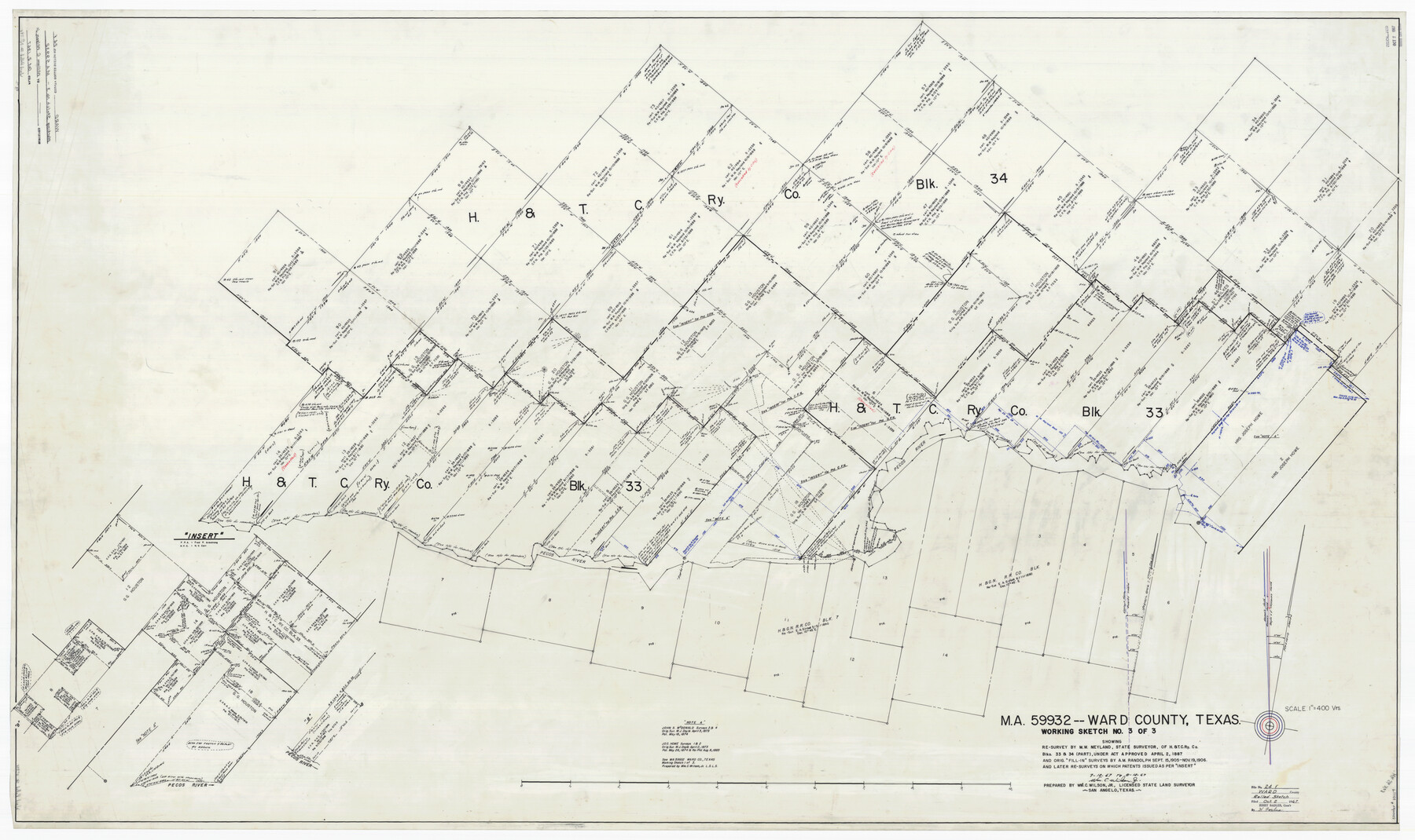
MA-59932 - Working Sketch 3 of 3 showing re-survey by M.W. Neyland of H. & T. C. Ry. Co. Blks. 33 & 34 (part), under act approved April 2, 1887 and orig. "fill-in" surs. by A.M. Randolph, Sept. 15, 1905 - Nov. 19, 1906
-
Map/Doc
10117
-
Collection
General Map Collection
-
Object Dates
1967/8/12 (Creation Date)
1967/10/2 (File Date)
-
People and Organizations
Wm. C. Wilson, Jr. (Surveyor/Engineer)
-
Counties
Ward Reeves Pecos
-
Subjects
Surveying Rolled Sketch
-
Height x Width
43.0 x 72.4 inches
109.2 x 183.9 cm
-
Medium
mylar, print
-
Scale
1" = 400 varas
Part of: General Map Collection
Pecos County Rolled Sketch 65

Print $20.00
- Digital $50.00
Pecos County Rolled Sketch 65
1928
Size 37.9 x 33.8 inches
Map/Doc 9699
Wise County Working Sketch 20

Print $20.00
- Digital $50.00
Wise County Working Sketch 20
1979
Size 22.8 x 27.3 inches
Map/Doc 72634
Comal County Sketch File 18

Print $4.00
- Digital $50.00
Comal County Sketch File 18
Size 6.7 x 13.0 inches
Map/Doc 19037
Swisher County

Print $20.00
- Digital $50.00
Swisher County
1887
Size 21.2 x 18.4 inches
Map/Doc 4062
Stephens County Working Sketch 21

Print $20.00
- Digital $50.00
Stephens County Working Sketch 21
1975
Size 34.7 x 31.9 inches
Map/Doc 63964
Martin County Rolled Sketch 3

Print $20.00
- Digital $50.00
Martin County Rolled Sketch 3
Size 29.2 x 15.4 inches
Map/Doc 6664
Ellis County Sketch File 20

Print $19.00
- Digital $50.00
Ellis County Sketch File 20
1869
Size 12.8 x 8.2 inches
Map/Doc 21869
Padre Island National Seashore, Texas - Dependent Resurvey

Print $4.00
- Digital $50.00
Padre Island National Seashore, Texas - Dependent Resurvey
2001
Size 18.3 x 24.2 inches
Map/Doc 60546
Amerique Septentrionale

Print $20.00
- Digital $50.00
Amerique Septentrionale
1650
Size 17.2 x 23.1 inches
Map/Doc 93684
Flight Mission No. BRA-3M, Frame 121, Jefferson County

Print $20.00
- Digital $50.00
Flight Mission No. BRA-3M, Frame 121, Jefferson County
1953
Size 18.8 x 22.3 inches
Map/Doc 85395
Gonzales County Working Sketch 3

Print $20.00
- Digital $50.00
Gonzales County Working Sketch 3
1943
Size 37.8 x 41.5 inches
Map/Doc 63218
Sulphur River, Bassett Sheet

Print $20.00
- Digital $50.00
Sulphur River, Bassett Sheet
1939
Size 24.8 x 32.0 inches
Map/Doc 78322
You may also like
Sherman County

Print $20.00
- Digital $50.00
Sherman County
1932
Size 43.1 x 39.9 inches
Map/Doc 63036
New Map of the City of New York, with Brooklyn & part of Williamsburg

Print $20.00
- Digital $50.00
New Map of the City of New York, with Brooklyn & part of Williamsburg
1839
Size 14.4 x 12.3 inches
Map/Doc 95909
Flight Mission No. BRA-7M, Frame 146, Jefferson County

Print $20.00
- Digital $50.00
Flight Mission No. BRA-7M, Frame 146, Jefferson County
1953
Size 16.1 x 16.1 inches
Map/Doc 85540
Scurry County Working Sketch 10

Print $20.00
- Digital $50.00
Scurry County Working Sketch 10
1990
Size 25.7 x 28.7 inches
Map/Doc 63839
Brewster County Rolled Sketch 93

Print $20.00
- Digital $50.00
Brewster County Rolled Sketch 93
1935
Size 24.1 x 43.1 inches
Map/Doc 5251

Brown County Sketch File X

Print $4.00
- Digital $50.00
Brown County Sketch File X
1882
Size 8.1 x 11.7 inches
Map/Doc 16580
Hale County Sketch File 9

Print $14.00
- Digital $50.00
Hale County Sketch File 9
1893
Size 6.1 x 2.6 inches
Map/Doc 24730
Flight Mission No. CGN-3P, Frame 21, San Patricio County

Print $20.00
- Digital $50.00
Flight Mission No. CGN-3P, Frame 21, San Patricio County
1956
Size 18.2 x 22.0 inches
Map/Doc 86979
Duval County Sketch File 20

Print $20.00
- Digital $50.00
Duval County Sketch File 20
1880
Size 17.9 x 14.6 inches
Map/Doc 11384
Pecos County Sketch File 67

Print $76.00
- Digital $50.00
Pecos County Sketch File 67
1919
Size 14.1 x 8.8 inches
Map/Doc 33828
Hutchinson County Working Sketch 13

Print $20.00
- Digital $50.00
Hutchinson County Working Sketch 13
1926
Size 22.6 x 31.5 inches
Map/Doc 66371