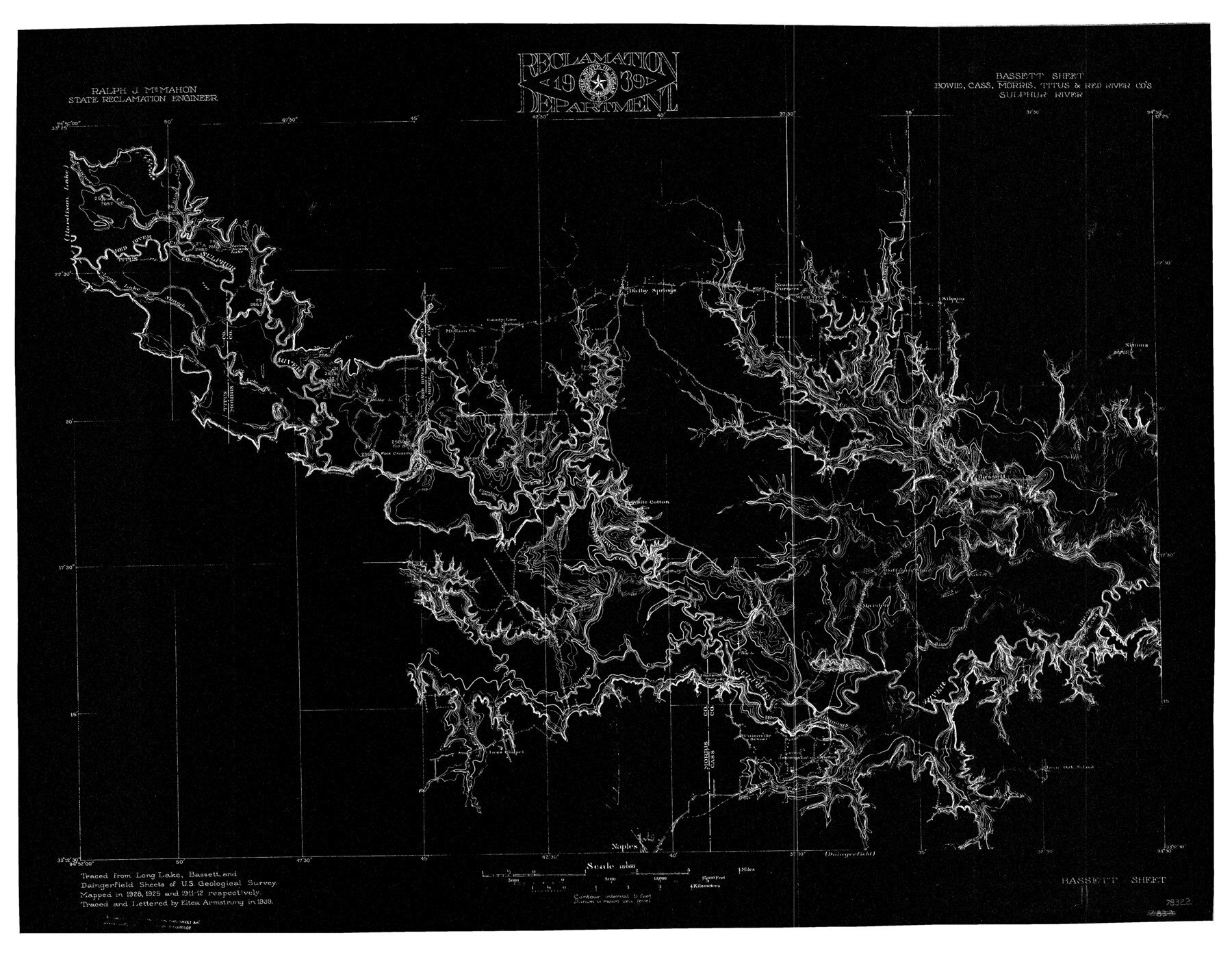
Sulphur River, Bassett Sheet
-
Map/Doc
78322
-
Collection
General Map Collection
-
Object Dates
1939 (Creation Date)
-
People and Organizations
Texas State Reclamation Department (Publisher)
Eltea Armstrong (Draftsman)
Eltea Armstrong (Compiler)
-
Counties
Bowie Cass Morris Titus Red River
-
Subjects
River Surveys Topographic
-
Height x Width
24.8 x 32.0 inches
63.0 x 81.3 cm
-
Comments
Bassett Sheet located next to the Hardison Lake Sheet.
Creeks continued: Dalby, Boothe, Village, Poke, Whiteoak, Caney, Calvert, Eds, Blythe, Ward, Weaver, Bassett, Mill, Elliott, Brooks
Branches: Murphy, Stephenson Ferry, Tuck, Crews
Slough:
Part of: General Map Collection
Reagan County

Print $40.00
- Digital $50.00
Reagan County
1940
Size 50.8 x 41.2 inches
Map/Doc 95621
Runnels County Working Sketch 25

Print $20.00
- Digital $50.00
Runnels County Working Sketch 25
1955
Size 38.2 x 47.1 inches
Map/Doc 63621
Young County Working Sketch 18

Print $20.00
- Digital $50.00
Young County Working Sketch 18
1960
Size 23.9 x 29.2 inches
Map/Doc 62041
Bee County Working Sketch 1

Print $20.00
- Digital $50.00
Bee County Working Sketch 1
Size 23.2 x 40.4 inches
Map/Doc 67251
[Surveys in the Montgomery District: San Jacinto River and Caney Creek, Navidad, Navasota]
![33, [Surveys in the Montgomery District: San Jacinto River and Caney Creek, Navidad, Navasota], General Map Collection](https://historictexasmaps.com/wmedia_w700/maps/33.tif.jpg)
Print $2.00
- Digital $50.00
[Surveys in the Montgomery District: San Jacinto River and Caney Creek, Navidad, Navasota]
1846
Size 8.8 x 6.0 inches
Map/Doc 33
Palo Pinto County Working Sketch 14

Print $20.00
- Digital $50.00
Palo Pinto County Working Sketch 14
1960
Size 27.2 x 27.4 inches
Map/Doc 71397
Hartley County Boundary File 1a

Print $50.00
- Digital $50.00
Hartley County Boundary File 1a
Size 14.1 x 8.8 inches
Map/Doc 54437
Glasscock County Rolled Sketch 17

Print $20.00
- Digital $50.00
Glasscock County Rolled Sketch 17
Size 21.6 x 27.4 inches
Map/Doc 6021
Upton County Rolled Sketch 60

Print $20.00
- Digital $50.00
Upton County Rolled Sketch 60
2021
Size 35.9 x 24.0 inches
Map/Doc 96569
Travis County Sketch File 48

Print $6.00
- Digital $50.00
Travis County Sketch File 48
1940
Size 11.4 x 8.8 inches
Map/Doc 38377
Bowie County Sketch File 7d

Print $40.00
- Digital $50.00
Bowie County Sketch File 7d
1927
Size 16.2 x 13.7 inches
Map/Doc 10944
Refugio County Boundary File 6

Print $10.00
- Digital $50.00
Refugio County Boundary File 6
Size 14.3 x 8.8 inches
Map/Doc 58257
You may also like
Seagraves, Gaines County, Texas, Located in Surveys 10 and 15, Block C-34

Print $20.00
- Digital $50.00
Seagraves, Gaines County, Texas, Located in Surveys 10 and 15, Block C-34
Size 33.3 x 23.8 inches
Map/Doc 92687
General Highway Map. Detail of Cities and Towns in El Paso County, Texas [El Paso and vicinity]
![79085, General Highway Map. Detail of Cities and Towns in El Paso County, Texas [El Paso and vicinity], Texas State Library and Archives](https://historictexasmaps.com/wmedia_w700/maps/79085.tif.jpg)
Print $20.00
General Highway Map. Detail of Cities and Towns in El Paso County, Texas [El Paso and vicinity]
1940
Size 24.7 x 18.3 inches
Map/Doc 79085
Land grants from the state of Tamaulipas in the trans-Nueces

Land grants from the state of Tamaulipas in the trans-Nueces
2009
Size 11.0 x 8.5 inches
Map/Doc 94040
Sabine County Working Sketch 1

Print $20.00
- Digital $50.00
Sabine County Working Sketch 1
1922
Size 17.7 x 17.7 inches
Map/Doc 63672
Reeves County Working Sketch 50

Print $20.00
- Digital $50.00
Reeves County Working Sketch 50
1974
Size 45.3 x 30.4 inches
Map/Doc 63493
Shelby County Working Sketch 26

Print $20.00
- Digital $50.00
Shelby County Working Sketch 26
1990
Size 11.3 x 12.2 inches
Map/Doc 63880
Brewster County Working Sketch 5

Print $20.00
- Digital $50.00
Brewster County Working Sketch 5
1908
Size 28.0 x 22.0 inches
Map/Doc 67538
Hudspeth County Working Sketch 5

Print $20.00
- Digital $50.00
Hudspeth County Working Sketch 5
1921
Size 27.8 x 38.8 inches
Map/Doc 66286
Burnet County Sketch File 25

Print $4.00
- Digital $50.00
Burnet County Sketch File 25
1873
Size 8.1 x 8.6 inches
Map/Doc 16725
Jones County Sketch File 9

Print $22.00
- Digital $50.00
Jones County Sketch File 9
Size 8.3 x 7.5 inches
Map/Doc 28495
Pecos County Sketch File 87

Print $18.00
- Digital $50.00
Pecos County Sketch File 87
1916
Size 13.3 x 8.9 inches
Map/Doc 33975
Uvalde County Working Sketch 11

Print $20.00
- Digital $50.00
Uvalde County Working Sketch 11
1943
Size 17.6 x 16.6 inches
Map/Doc 72081