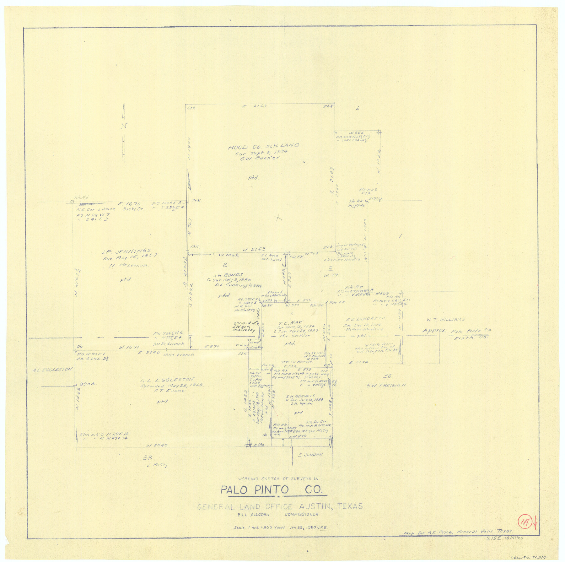
Palo Pinto County Working Sketch 14
- 
                          Map/Doc71397
- 
                            CollectionGeneral Map Collection
- 
                            Object Dates1/29/1960 (Creation Date)
- 
                            CountiesPalo Pinto
- 
                            SubjectsSurveying Working Sketch
- 
                            Height x Width27.2 x 27.4 inches69.1 x 69.6 cm
- 
                            Scale1" = 300 varas
Part of: General Map Collection
            Tarrant County Sketch File 3


                                            Print $4.00                    
                                             -                         Digital $50.00                                    
                Tarrant County Sketch File 3
Size 11.8 x 8.2 inches
                                Map/Doc 37676
            
            Flight Mission No. DQO-2K, Frame 147, Galveston County


                                            Print $20.00                    
                                             -                         Digital $50.00                                    
                Flight Mission No. DQO-2K, Frame 147, Galveston County
1952
Size 18.8 x 22.6 inches
                                Map/Doc 85044
            
            Harris County Working Sketch 60


                                            Print $20.00                    
                                             -                         Digital $50.00                                    
                Harris County Working Sketch 60
1953
Size 31.8 x 35.2 inches
                                Map/Doc 65952
            
            Pecos County Sketch File 90


                                            Print $20.00                    
                                             -                         Digital $50.00                                    
                Pecos County Sketch File 90
1935
Size 17.7 x 22.4 inches
                                Map/Doc 12183
            
            [Beaumont, Sour Lake and Western Ry. Right of Way and Alignment - Frisco]
            
                                    ![64106, [Beaumont, Sour Lake and Western Ry. Right of Way and Alignment - Frisco], General Map Collection](https://historictexasmaps.com/wmedia_w700/maps/64106.tif.jpg) 


    ![64106, [Beaumont, Sour Lake and Western Ry. Right of Way and Alignment - Frisco], General Map Collection](https://historictexasmaps.com/wmedia_w700/maps/64106.tif.jpg) 
                                
            
                                            Print $20.00                    
                                             -                         Digital $50.00                                    
                [Beaumont, Sour Lake and Western Ry. Right of Way and Alignment - Frisco]
1910
Size 19.9 x 45.9 inches
                                Map/Doc 64106
            
            Texas Gulf Coast Map from the Sabine River to the Rio Grande as subdivided for mineral development


                                            Print $40.00                    
                                             -                         Digital $50.00                                    
                Texas Gulf Coast Map from the Sabine River to the Rio Grande as subdivided for mineral development
1948
Size 44.0 x 69.2 inches
                                Map/Doc 2908
            
            Colorado County Working Sketch 22


                                            Print $20.00                    
                                             -                         Digital $50.00                                    
                Colorado County Working Sketch 22
1964
Size 31.9 x 42.5 inches
                                Map/Doc 68122
            
            Jeff Davis County Working Sketch 44


                                            Print $20.00                    
                                             -                         Digital $50.00                                    
                Jeff Davis County Working Sketch 44
1984
Size 28.8 x 37.4 inches
                                Map/Doc 66539
            
            Jesse Devore League


                                            Print $20.00                    
                                             -                         Digital $50.00                                    
                Jesse Devore League
1919
Size 45.6 x 37.4 inches
                                Map/Doc 65460
            
            Victoria County Rolled Sketch 4C


                                            Print $40.00                    
                                             -                         Digital $50.00                                    
                Victoria County Rolled Sketch 4C
1963
Size 65.0 x 43.3 inches
                                Map/Doc 10097
            
            Nueces County Rolled Sketch 97


                                            Print $68.00                    
                                             -                         Digital $50.00                                    
                Nueces County Rolled Sketch 97
1983
Size 24.2 x 36.9 inches
                                Map/Doc 7057
            
            Moore County Sketch File 12


                                            Print $20.00                    
                                             -                         Digital $50.00                                    
                Moore County Sketch File 12
1939
Size 27.3 x 19.9 inches
                                Map/Doc 42130
            You may also like
            Packery Channel


                                            Print $20.00                    
                                             -                         Digital $50.00                                    
                Packery Channel
1958
Size 21.1 x 24.3 inches
                                Map/Doc 3007
            
            Guadalupe County Sketch File 1a


                                            Print $4.00                    
                                             -                         Digital $50.00                                    
                Guadalupe County Sketch File 1a
1859
Size 12.6 x 7.9 inches
                                Map/Doc 24646
            
            Reeves County Working Sketch Graphic Index


                                            Print $20.00                    
                                             -                         Digital $50.00                                    
                Reeves County Working Sketch Graphic Index
1945
Size 47.3 x 38.1 inches
                                Map/Doc 76682
            
            Brazoria County Sketch File 8


                                            Print $4.00                    
                                             -                         Digital $50.00                                    
                Brazoria County Sketch File 8
1874
Size 12.4 x 8.4 inches
                                Map/Doc 14934
            
            [East Part of Block 37,  Township 2 North]
            
                                    ![91395, [East Part of Block 37, Township 2 North], Twichell Survey Records](https://historictexasmaps.com/wmedia_w700/maps/91395-1.tif.jpg) 


    ![91395, [East Part of Block 37, Township 2 North], Twichell Survey Records](https://historictexasmaps.com/wmedia_w700/maps/91395-1.tif.jpg) 
                                
            
                                            Print $3.00                    
                                             -                         Digital $50.00                                    
                [East Part of Block 37, Township 2 North]
Size 9.6 x 17.6 inches
                                Map/Doc 91395
            
            Plat of a survey of the North part of section 16, Block 362, Martha McBride, Presidio County, Texas


                                            Print $4.00                    
                                             -                         Digital $50.00                                    
                Plat of a survey of the North part of section 16, Block 362, Martha McBride, Presidio County, Texas
1989
Size 24.1 x 29.3 inches
                                Map/Doc 60520
            
            Motley County Sketch File 6 (S)


                                            Print $22.00                    
                                             -                         Digital $50.00                                    
                Motley County Sketch File 6 (S)
Size 12.9 x 13.8 inches
                                Map/Doc 32145
            
            Schleicher County Sketch File 25


                                            Print $20.00                    
                                             -                         Digital $50.00                                    
                Schleicher County Sketch File 25
1937
Size 24.1 x 17.5 inches
                                Map/Doc 12304
            
            Hutchinson County Working Sketch 46


                                            Print $20.00                    
                                             -                         Digital $50.00                                    
                Hutchinson County Working Sketch 46
1979
Size 20.4 x 22.3 inches
                                Map/Doc 66406
            
            [Sketch for Mineral Application 36425 - Jefferson County, Ley C. Moore]
            
                                    ![65616, [Sketch for Mineral Application 36425 - Jefferson County, Ley C. Moore], General Map Collection](https://historictexasmaps.com/wmedia_w700/maps/65616.tif.jpg) 


    ![65616, [Sketch for Mineral Application 36425 - Jefferson County, Ley C. Moore], General Map Collection](https://historictexasmaps.com/wmedia_w700/maps/65616.tif.jpg) 
                                
            
                                            Print $40.00                    
                                             -                         Digital $50.00                                    
                [Sketch for Mineral Application 36425 - Jefferson County, Ley C. Moore]
1942
Size 49.2 x 35.0 inches
                                Map/Doc 65616
            
            Dickens County Sketch File 31


                                            Print $20.00                    
                                             -                         Digital $50.00                                    
                Dickens County Sketch File 31
Size 22.3 x 9.5 inches
                                Map/Doc 11327
            
            Sutton County Rolled Sketch 47


                                            Print $20.00                    
                                             -                         Digital $50.00                                    
                Sutton County Rolled Sketch 47
Size 17.0 x 24.3 inches
                                Map/Doc 7888
            