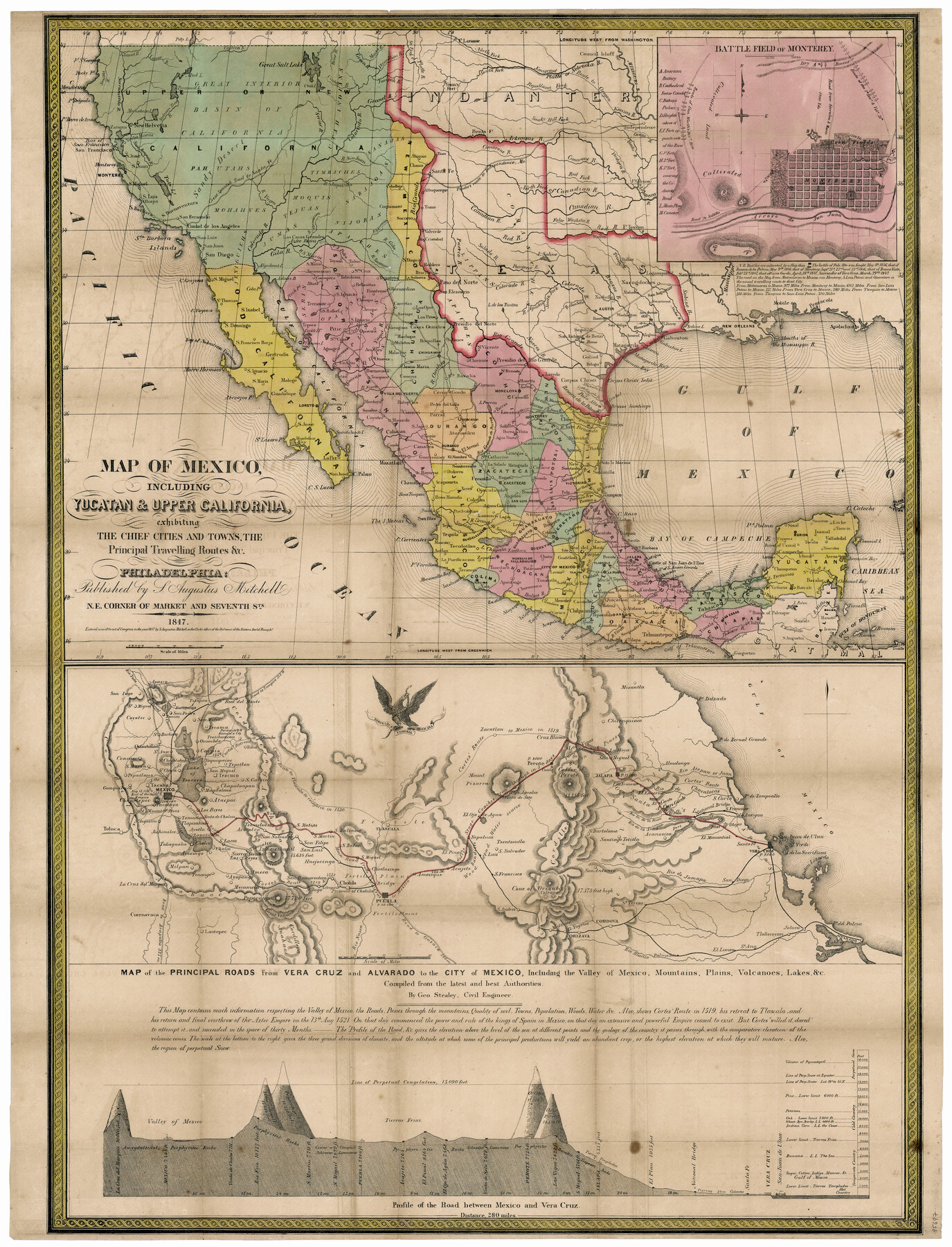
Map of Mexico, Including Yucatan & Upper California, exhibiting the Chief Cities and Towns, the Principal Travelling Routes &c.
Inset Map: Battlefield of Monterey [sic]
-
Map/Doc
95697
-
Collection
General Map Collection
-
Object Dates
1847 (Creation Date)
-
People and Organizations
S. Augustus Mitchell (Publisher)
Samuel Augustus Mitchell (Cartographer)
Geo. Stealey (Surveyor/Engineer)
-
Subjects
Mexico Military State of Texas
-
Height x Width
33.3 x 25.4 inches
84.6 x 64.5 cm
-
Medium
paper, etching/engraving/lithograph
-
Comments
Also includes below the main map: Map of the Principal Roads from Vera Cruz and Alvarado to the City of Mexico, Including the Valley of Mexico, Mountains, Plains, Volcanoes, Lakes &c.
Part of: General Map Collection
Crockett County Working Sketch 65

Print $20.00
- Digital $50.00
Crockett County Working Sketch 65
1957
Size 32.3 x 38.0 inches
Map/Doc 68398
Cameron County Boundary File 4

Print $42.00
- Digital $50.00
Cameron County Boundary File 4
Size 10.4 x 8.2 inches
Map/Doc 51110
San Patricio County

Print $40.00
- Digital $50.00
San Patricio County
1939
Size 39.8 x 50.6 inches
Map/Doc 63019
Live Oak County Working Sketch 4

Print $20.00
- Digital $50.00
Live Oak County Working Sketch 4
1914
Size 16.8 x 14.0 inches
Map/Doc 70589
Map of Comal County

Print $20.00
- Digital $50.00
Map of Comal County
1862
Size 18.6 x 22.0 inches
Map/Doc 3429
Robertson County Rolled Sketch 1A

Print $20.00
- Digital $50.00
Robertson County Rolled Sketch 1A
1966
Size 45.3 x 28.1 inches
Map/Doc 9863
Brewster County Working Sketch 119

Print $20.00
- Digital $50.00
Brewster County Working Sketch 119
1909
Size 29.3 x 29.0 inches
Map/Doc 67719
Flight Mission No. BRA-16M, Frame 87, Jefferson County

Print $20.00
- Digital $50.00
Flight Mission No. BRA-16M, Frame 87, Jefferson County
1953
Size 18.6 x 22.3 inches
Map/Doc 85699
Map of north end of Brazos Island

Print $20.00
- Digital $50.00
Map of north end of Brazos Island
Size 27.7 x 18.3 inches
Map/Doc 72907
Orange County Rolled Sketch 12

Print $20.00
- Digital $50.00
Orange County Rolled Sketch 12
Size 23.6 x 19.2 inches
Map/Doc 7179
Kaufman County Working Sketch 1

Print $20.00
- Digital $50.00
Kaufman County Working Sketch 1
1921
Size 21.4 x 47.6 inches
Map/Doc 66664
[G.C. and S. F. R.R. Co. Through Bosque County from McLennan Co. and E. to Hill Co. Station M. P. 259 to M. P. 297]
![64563, [G.C. and S. F. R.R. Co. Through Bosque County from McLennan Co. and E. to Hill Co. Station M. P. 259 to M. P. 297], General Map Collection](https://historictexasmaps.com/wmedia_w700/maps/64563-1.tif.jpg)
Print $40.00
- Digital $50.00
[G.C. and S. F. R.R. Co. Through Bosque County from McLennan Co. and E. to Hill Co. Station M. P. 259 to M. P. 297]
Size 21.7 x 120.5 inches
Map/Doc 64563
You may also like
Upton County Rolled Sketch 59A

Print $20.00
- Digital $50.00
Upton County Rolled Sketch 59A
Size 35.4 x 45.6 inches
Map/Doc 76422
El Paso County Rolled Sketch 65

Print $20.00
- Digital $50.00
El Paso County Rolled Sketch 65
2012
Size 24.5 x 36.8 inches
Map/Doc 93327
Washington County

Print $20.00
- Digital $50.00
Washington County
1920
Size 32.5 x 47.2 inches
Map/Doc 16918
Live Oak County Working Sketch 33

Print $20.00
- Digital $50.00
Live Oak County Working Sketch 33
1992
Size 25.9 x 35.1 inches
Map/Doc 70618
Winkler County Working Sketch 20

Print $20.00
- Digital $50.00
Winkler County Working Sketch 20
1990
Size 22.3 x 24.0 inches
Map/Doc 72614
Bell County Sketch File 26

Print $14.00
- Digital $50.00
Bell County Sketch File 26
1886
Size 14.2 x 8.8 inches
Map/Doc 14426
Flight Mission No. CLL-3N, Frame 13, Willacy County

Print $20.00
- Digital $50.00
Flight Mission No. CLL-3N, Frame 13, Willacy County
1954
Size 18.4 x 22.1 inches
Map/Doc 87079
Flight Mission No. BRA-7M, Frame 199, Jefferson County

Print $20.00
- Digital $50.00
Flight Mission No. BRA-7M, Frame 199, Jefferson County
1953
Size 18.7 x 22.4 inches
Map/Doc 85567
Lampasas County Oil Field

Print $20.00
Lampasas County Oil Field
1920
Size 22.4 x 28.8 inches
Map/Doc 79326
Kinney County Sketch File 11

Print $20.00
- Digital $50.00
Kinney County Sketch File 11
1885
Size 28.3 x 18.1 inches
Map/Doc 11939
Bandera County Rolled Sketch 7

Print $20.00
- Digital $50.00
Bandera County Rolled Sketch 7
Size 42.7 x 29.0 inches
Map/Doc 5118
[West Half of Hutchinson County South of the Canadian River]
![91179, [West Half of Hutchinson County South of the Canadian River], Twichell Survey Records](https://historictexasmaps.com/wmedia_w700/maps/91179-1.tif.jpg)
Print $20.00
- Digital $50.00
[West Half of Hutchinson County South of the Canadian River]
Size 18.4 x 17.0 inches
Map/Doc 91179