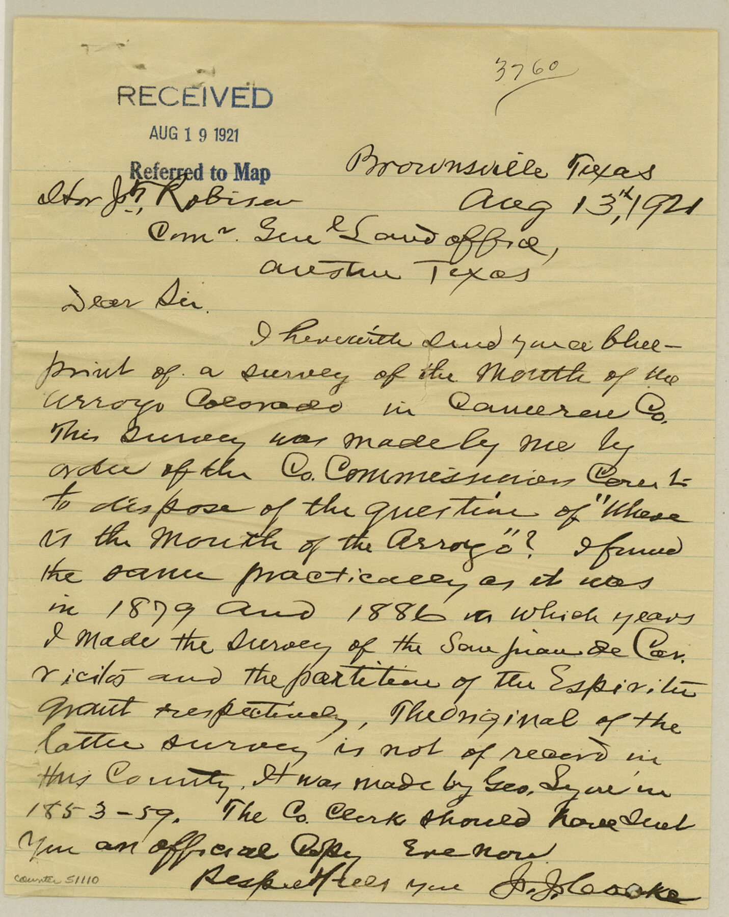
Cameron County Boundary File 4
-
Map/Doc
51110
-
Collection
General Map Collection
-
Counties
Cameron
-
Subjects
County Boundaries
-
Height x Width
10.4 x 8.2 inches
26.4 x 20.8 cm
Part of: General Map Collection
General Land Office and State Reclamation Department - An Index Map

Print $20.00
- Digital $50.00
General Land Office and State Reclamation Department - An Index Map
1930
Size 26.2 x 16.6 inches
Map/Doc 65069
Anderson County Sketch File 17

Print $4.00
- Digital $50.00
Anderson County Sketch File 17
1871
Size 10.2 x 7.7 inches
Map/Doc 12789
Howard County Sketch File A

Print $44.00
- Digital $50.00
Howard County Sketch File A
Size 7.2 x 7.6 inches
Map/Doc 26837
A Pocket Guide to Austin, Texas - Area Map and Downtown Map

A Pocket Guide to Austin, Texas - Area Map and Downtown Map
Size 17.0 x 20.1 inches
Map/Doc 94385
Gillespie County Sketch File 17

Print $8.00
- Digital $50.00
Gillespie County Sketch File 17
1994
Size 11.2 x 8.7 inches
Map/Doc 24157
Carte des Côtes du Golfe du Mexique compris entre la Pointe Sud de la Presqu'Ile de la Floride et la Pointe Nord de la Presqu'Ile d'Yucatan

Print $20.00
- Digital $50.00
Carte des Côtes du Golfe du Mexique compris entre la Pointe Sud de la Presqu'Ile de la Floride et la Pointe Nord de la Presqu'Ile d'Yucatan
1800
Size 26.0 x 37.5 inches
Map/Doc 95322
Lampasas County Sketch File 7

Print $4.00
- Digital $50.00
Lampasas County Sketch File 7
1871
Size 8.4 x 8.2 inches
Map/Doc 29402
Map of the State of Texas

Print $40.00
- Digital $50.00
Map of the State of Texas
1879
Size 102.3 x 56.2 inches
Map/Doc 93384
Approaches to Galveston Bay

Print $40.00
- Digital $50.00
Approaches to Galveston Bay
1976
Size 50.3 x 35.9 inches
Map/Doc 69883
Current Miscellaneous File 43

Print $4.00
- Digital $50.00
Current Miscellaneous File 43
Size 11.2 x 8.7 inches
Map/Doc 73983
Hunt County Sketch File 16b

Print $6.00
- Digital $50.00
Hunt County Sketch File 16b
Size 6.7 x 7.4 inches
Map/Doc 27111
Orange County Working Sketch 39

Print $20.00
- Digital $50.00
Orange County Working Sketch 39
1966
Size 20.5 x 27.8 inches
Map/Doc 71371
You may also like
Presidio County Rolled Sketch S1

Print $20.00
- Digital $50.00
Presidio County Rolled Sketch S1
Size 13.3 x 18.8 inches
Map/Doc 7414
Denton County Boundary File 1a

Print $24.00
- Digital $50.00
Denton County Boundary File 1a
Size 12.4 x 8.1 inches
Map/Doc 52401
[R. M. Thompson Block A, Jones County School Land, and vicinity]
![91202, [R. M. Thompson Block A, Jones County School Land, and vicinity], Twichell Survey Records](https://historictexasmaps.com/wmedia_w700/maps/91202-1.tif.jpg)
Print $20.00
- Digital $50.00
[R. M. Thompson Block A, Jones County School Land, and vicinity]
Size 15.8 x 30.0 inches
Map/Doc 91202
[Northwest corner of the County]
![90873, [Northwest corner of the County], Twichell Survey Records](https://historictexasmaps.com/wmedia_w700/maps/90873-2.tif.jpg)
Print $20.00
- Digital $50.00
[Northwest corner of the County]
1903
Size 19.1 x 21.5 inches
Map/Doc 90873
Gregg County Working Sketch 12

Print $20.00
- Digital $50.00
Gregg County Working Sketch 12
1940
Size 11.0 x 18.9 inches
Map/Doc 63279
Flight Mission No. DQO-8K, Frame 86, Galveston County

Print $20.00
- Digital $50.00
Flight Mission No. DQO-8K, Frame 86, Galveston County
1952
Size 18.4 x 22.3 inches
Map/Doc 85188
Hudspeth County Working Sketch 16

Print $40.00
- Digital $50.00
Hudspeth County Working Sketch 16
Size 22.2 x 56.6 inches
Map/Doc 69649
Flight Mission No. BQR-3K, Frame 160, Brazoria County

Print $20.00
- Digital $50.00
Flight Mission No. BQR-3K, Frame 160, Brazoria County
1952
Size 18.6 x 22.4 inches
Map/Doc 83987
The Mexican Company Empresario Colony. May 1, 1832

Print $20.00
The Mexican Company Empresario Colony. May 1, 1832
2020
Size 15.0 x 21.7 inches
Map/Doc 95999
Smith County Rolled Sketch 6A2

Print $40.00
- Digital $50.00
Smith County Rolled Sketch 6A2
1934
Size 48.7 x 36.7 inches
Map/Doc 10702
Collingsworth County Sketch File 6

Print $4.00
- Digital $50.00
Collingsworth County Sketch File 6
1896
Size 11.4 x 9.1 inches
Map/Doc 18882
Rusk County Sketch File 13

Print $4.00
Rusk County Sketch File 13
Size 8.6 x 6.4 inches
Map/Doc 35514