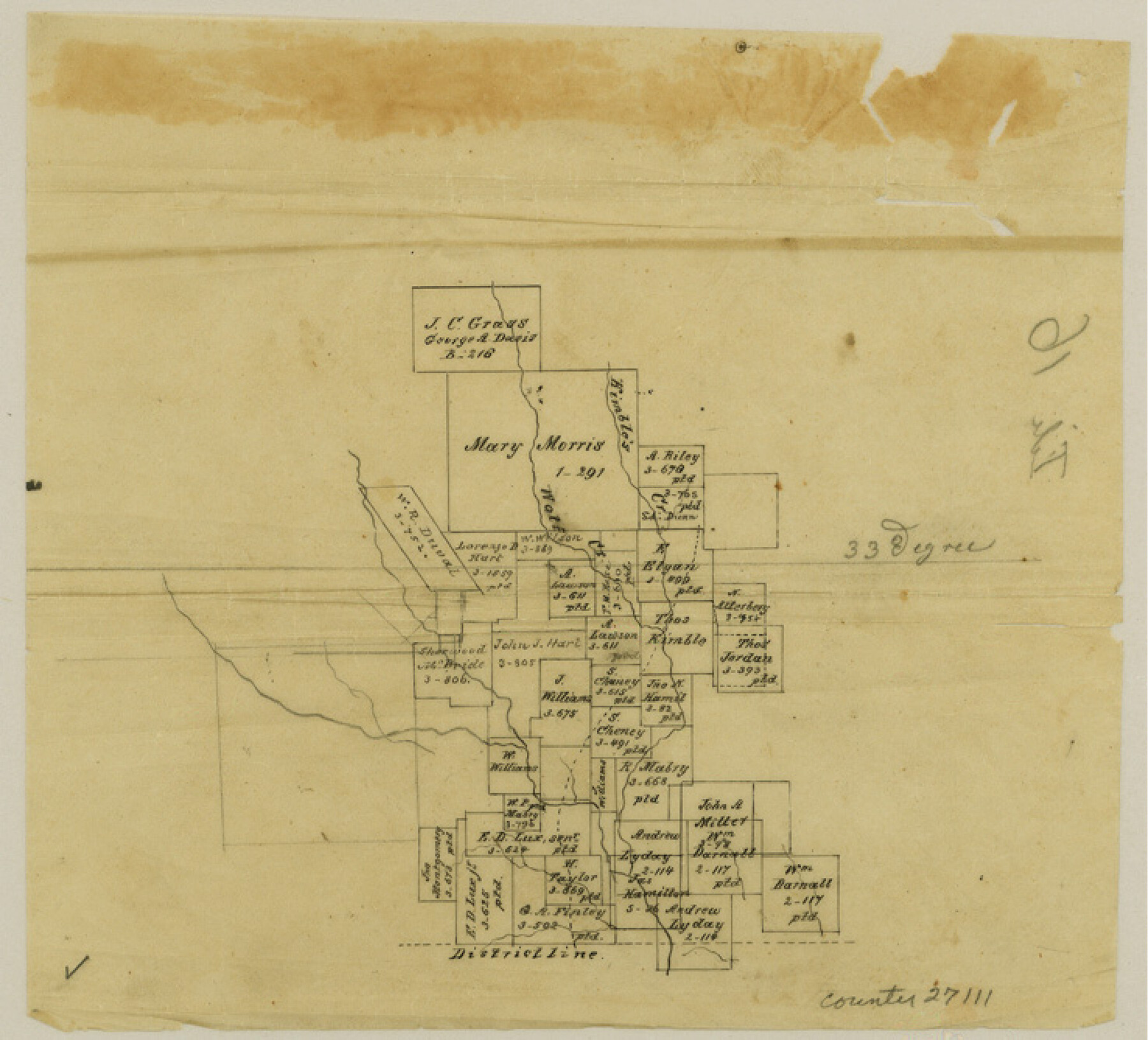
Hunt County Sketch File 16b
[Sketch south of Greenville]
-
Map/Doc
27111
-
Collection
General Map Collection
-
People and Organizations
Pressler (Surveyor/Engineer)
-
Counties
Hunt
-
Subjects
Surveying Sketch File
-
Height x Width
6.7 x 7.4 inches
17.0 x 18.8 cm
-
Medium
paper, manuscript
-
Features
Kimble's Creek
Wolf Creek
Part of: General Map Collection
Map of Robertson County

Print $40.00
- Digital $50.00
Map of Robertson County
1839
Size 56.2 x 33.0 inches
Map/Doc 4656
Galveston County NRC Article 33.136 Sketch 90

Print $144.00
- Digital $50.00
Galveston County NRC Article 33.136 Sketch 90
2021
Map/Doc 96930
Upper Galveston Bay, Houston Ship Channel, Dollar Pt. to Atkinson I.

Print $40.00
- Digital $50.00
Upper Galveston Bay, Houston Ship Channel, Dollar Pt. to Atkinson I.
1973
Size 49.8 x 36.8 inches
Map/Doc 69896
United States - Gulf Coast - Galveston to Rio Grande

Print $20.00
- Digital $50.00
United States - Gulf Coast - Galveston to Rio Grande
1919
Size 26.7 x 18.3 inches
Map/Doc 72746
Terry County Sketch File 15

Print $10.00
- Digital $50.00
Terry County Sketch File 15
1944
Size 11.3 x 8.9 inches
Map/Doc 38034
Current Miscellaneous File 24

Print $26.00
- Digital $50.00
Current Miscellaneous File 24
1953
Size 10.6 x 8.2 inches
Map/Doc 73883
Reeves County Working Sketch 10

Print $20.00
- Digital $50.00
Reeves County Working Sketch 10
1956
Size 26.0 x 37.2 inches
Map/Doc 63453
Flight Mission No. DAG-28K, Frame 31, Matagorda County

Print $20.00
- Digital $50.00
Flight Mission No. DAG-28K, Frame 31, Matagorda County
1953
Size 16.1 x 16.2 inches
Map/Doc 86599
Navigation Maps of Gulf Intracoastal Waterway, Port Arthur to Brownsville, Texas

Print $4.00
- Digital $50.00
Navigation Maps of Gulf Intracoastal Waterway, Port Arthur to Brownsville, Texas
1951
Size 16.6 x 21.5 inches
Map/Doc 65427
Wichita County Working Sketch 23

Print $20.00
- Digital $50.00
Wichita County Working Sketch 23
1963
Size 28.4 x 30.8 inches
Map/Doc 72533
[Surveys in Austin's Colony]
![78, [Surveys in Austin's Colony], General Map Collection](https://historictexasmaps.com/wmedia_w700/maps/78.tif.jpg)
Print $20.00
- Digital $50.00
[Surveys in Austin's Colony]
Size 16.0 x 13.0 inches
Map/Doc 78
Childress County Rolled Sketch 8A

Print $20.00
- Digital $50.00
Childress County Rolled Sketch 8A
Size 18.2 x 12.9 inches
Map/Doc 5443
You may also like
Kerr County Sketch File 5

Print $4.00
- Digital $50.00
Kerr County Sketch File 5
1878
Size 14.2 x 8.4 inches
Map/Doc 28865
Nueces County Rolled Sketch 3

Print $20.00
- Digital $50.00
Nueces County Rolled Sketch 3
1907
Size 17.3 x 34.2 inches
Map/Doc 6866
Harrison County Working Sketch 1

Print $20.00
- Digital $50.00
Harrison County Working Sketch 1
1919
Size 22.6 x 25.6 inches
Map/Doc 66021
Cameron County Sketch File 17

Print $24.00
- Digital $50.00
Cameron County Sketch File 17
2009
Size 11.0 x 8.5 inches
Map/Doc 95191
[Block B5, Capitol Leagues 217, 218, and 239]
![91438, [Block B5, Capitol Leagues 217, 218, and 239], Twichell Survey Records](https://historictexasmaps.com/wmedia_w700/maps/91438-1.tif.jpg)
Print $3.00
- Digital $50.00
[Block B5, Capitol Leagues 217, 218, and 239]
Size 15.1 x 10.0 inches
Map/Doc 91438
![92632, [League 280], Twichell Survey Records](https://historictexasmaps.com/wmedia_w700/maps/92632-1.tif.jpg)
Culberson County Working Sketch 10

Print $20.00
- Digital $50.00
Culberson County Working Sketch 10
1915
Size 28.9 x 31.0 inches
Map/Doc 68462
Rains County Working Sketch 9

Print $20.00
- Digital $50.00
Rains County Working Sketch 9
1976
Size 35.8 x 31.9 inches
Map/Doc 71835
Ramon de la Garza 11 Leagues Houston and Robertson Districts

Print $2.00
- Digital $50.00
Ramon de la Garza 11 Leagues Houston and Robertson Districts
Size 11.5 x 8.5 inches
Map/Doc 181
Oldham County Working Sketch 1

Print $20.00
- Digital $50.00
Oldham County Working Sketch 1
1901
Size 40.2 x 24.7 inches
Map/Doc 71323
[Sketch showing A. B. & M. Block 2]
![91701, [Sketch showing A. B. & M. Block 2], Twichell Survey Records](https://historictexasmaps.com/wmedia_w700/maps/91701-1.tif.jpg)
Print $2.00
- Digital $50.00
[Sketch showing A. B. & M. Block 2]
Size 7.5 x 5.8 inches
Map/Doc 91701
