Current Miscellaneous File 24
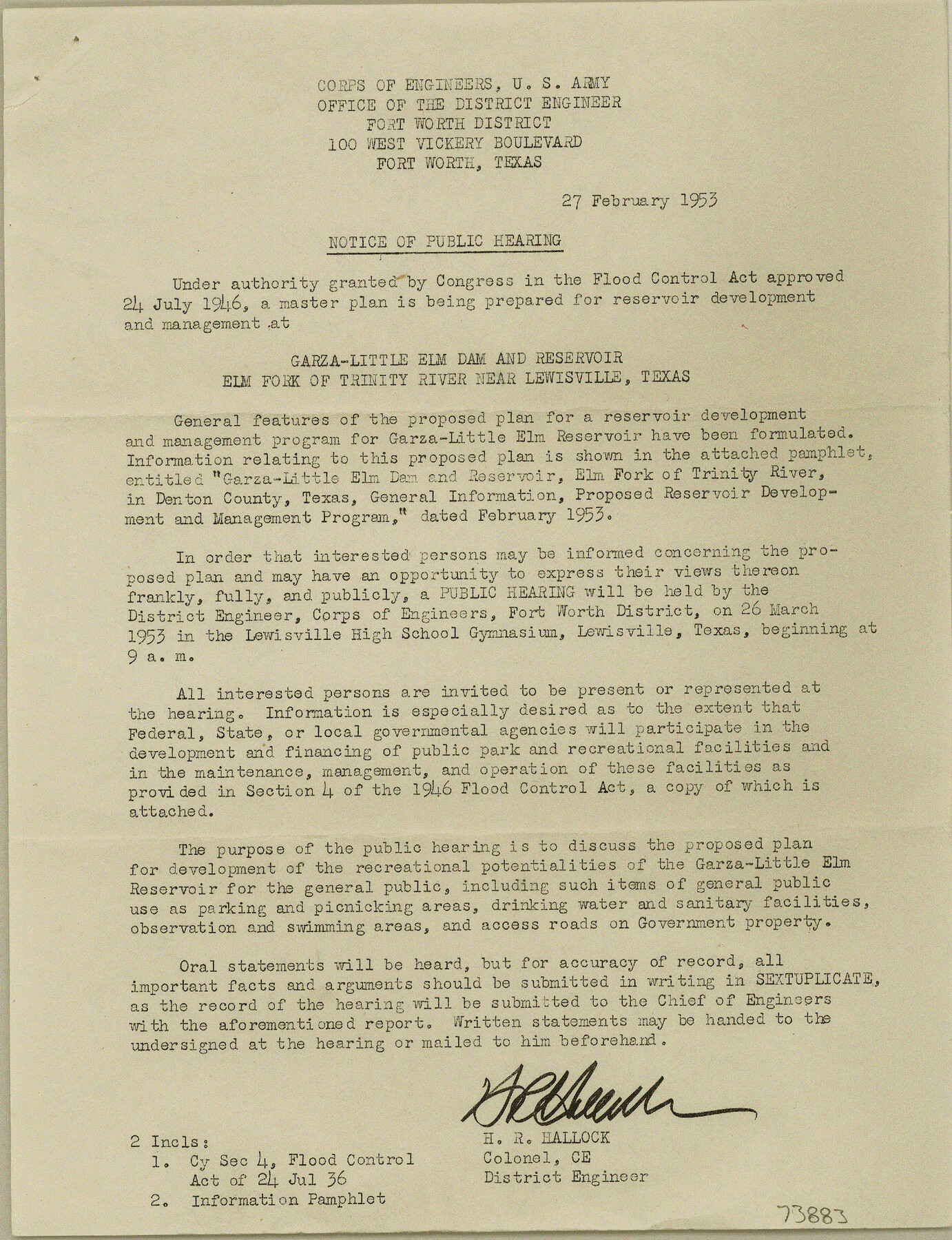
Notice of Public Hearing - Garza-Little Elm Dam and Reservoir, Elm Fork of Trinity River near Lewisville, Texas Denton County
-
Map/Doc
73883
-
Collection
General Map Collection
-
Object Dates
1953/2/27 (Creation Date)
1953/3/5 (File Date)
-
Subjects
Curiosities
-
Height x Width
10.6 x 8.2 inches
26.9 x 20.8 cm
Part of: General Map Collection
No. 1 - Survey for a road from the Brazo Santiago to the Rio Grande

Print $20.00
- Digital $50.00
No. 1 - Survey for a road from the Brazo Santiago to the Rio Grande
1847
Size 18.3 x 27.0 inches
Map/Doc 72873
San Patricio County Rolled Sketch 22

Print $20.00
- Digital $50.00
San Patricio County Rolled Sketch 22
1882
Size 19.3 x 23.9 inches
Map/Doc 7581
Brewster County Rolled Sketch 24E

Print $20.00
- Digital $50.00
Brewster County Rolled Sketch 24E
1906
Size 15.2 x 18.1 inches
Map/Doc 5212
Live Oak County Working Sketch 14

Print $20.00
- Digital $50.00
Live Oak County Working Sketch 14
1949
Size 27.9 x 42.1 inches
Map/Doc 70599
Flight Mission No. CLL-1N, Frame 76, Willacy County

Print $20.00
- Digital $50.00
Flight Mission No. CLL-1N, Frame 76, Willacy County
1954
Size 18.3 x 22.0 inches
Map/Doc 87022
Houston County Working Sketch 36

Print $40.00
- Digital $50.00
Houston County Working Sketch 36
1987
Size 61.2 x 43.6 inches
Map/Doc 78231
Gaines County Working Sketch 24

Print $20.00
- Digital $50.00
Gaines County Working Sketch 24
1983
Size 36.4 x 37.9 inches
Map/Doc 69324
Grayson County Sketch File 18

Print $6.00
- Digital $50.00
Grayson County Sketch File 18
1859
Size 12.2 x 7.9 inches
Map/Doc 24487
Orange County Working Sketch 48

Print $20.00
- Digital $50.00
Orange County Working Sketch 48
1991
Size 13.3 x 19.9 inches
Map/Doc 71380
Tyler County Working Sketch 24

Print $20.00
- Digital $50.00
Tyler County Working Sketch 24
1989
Size 34.8 x 40.6 inches
Map/Doc 69494
Brown County Sketch File 25

Print $6.00
- Digital $50.00
Brown County Sketch File 25
1890
Size 11.2 x 15.4 inches
Map/Doc 16623
Harris County Historic Topographic 17

Print $20.00
- Digital $50.00
Harris County Historic Topographic 17
1916
Size 29.5 x 22.7 inches
Map/Doc 65827
You may also like
Map Showing Lands Owned by Capitol Freehold Land and Investment Company, Ltd.

Print $20.00
- Digital $50.00
Map Showing Lands Owned by Capitol Freehold Land and Investment Company, Ltd.
1909
Size 36.4 x 25.2 inches
Map/Doc 90733
Flight Mission No. BRA-7M, Frame 207, Jefferson County

Print $20.00
- Digital $50.00
Flight Mission No. BRA-7M, Frame 207, Jefferson County
1953
Size 18.6 x 22.3 inches
Map/Doc 85575
Harris County Rolled Sketch HI

Print $20.00
- Digital $50.00
Harris County Rolled Sketch HI
1922
Size 30.9 x 42.0 inches
Map/Doc 9117
Atascosa County Working Sketch 38

Print $40.00
- Digital $50.00
Atascosa County Working Sketch 38
2011
Size 31.1 x 60.6 inches
Map/Doc 90031
Map Showing Colonel A.W. Doniphan's Route through the States of New Mexico, Chihuahua and Coahuila

Print $20.00
Map Showing Colonel A.W. Doniphan's Route through the States of New Mexico, Chihuahua and Coahuila
1847
Size 16.9 x 14.0 inches
Map/Doc 79729
Van Zandt County Working Sketch 9

Print $20.00
- Digital $50.00
Van Zandt County Working Sketch 9
1982
Size 12.6 x 11.7 inches
Map/Doc 72259
Map of the West Indies engraved to illustrate Mitchell's new intermediate geography

Print $20.00
- Digital $50.00
Map of the West Indies engraved to illustrate Mitchell's new intermediate geography
1885
Size 9.0 x 12.2 inches
Map/Doc 93524
Bee County Sketch File 30

Print $6.00
- Digital $50.00
Bee County Sketch File 30
Size 14.2 x 8.9 inches
Map/Doc 14341
General Highway Map, Swisher County, Texas

Print $20.00
General Highway Map, Swisher County, Texas
1940
Size 18.4 x 25.0 inches
Map/Doc 79250
Dickens County Rolled Sketch 7

Print $20.00
- Digital $50.00
Dickens County Rolled Sketch 7
1947
Size 33.6 x 23.6 inches
Map/Doc 5706
[Central Garza County]
![92659, [Central Garza County], Twichell Survey Records](https://historictexasmaps.com/wmedia_w700/maps/92659-1.tif.jpg)
Print $20.00
- Digital $50.00
[Central Garza County]
1906
Size 28.0 x 33.1 inches
Map/Doc 92659
Galveston County Rolled Sketch 34D

Print $71.00
- Digital $50.00
Galveston County Rolled Sketch 34D
1981
Size 9.9 x 15.1 inches
Map/Doc 45171