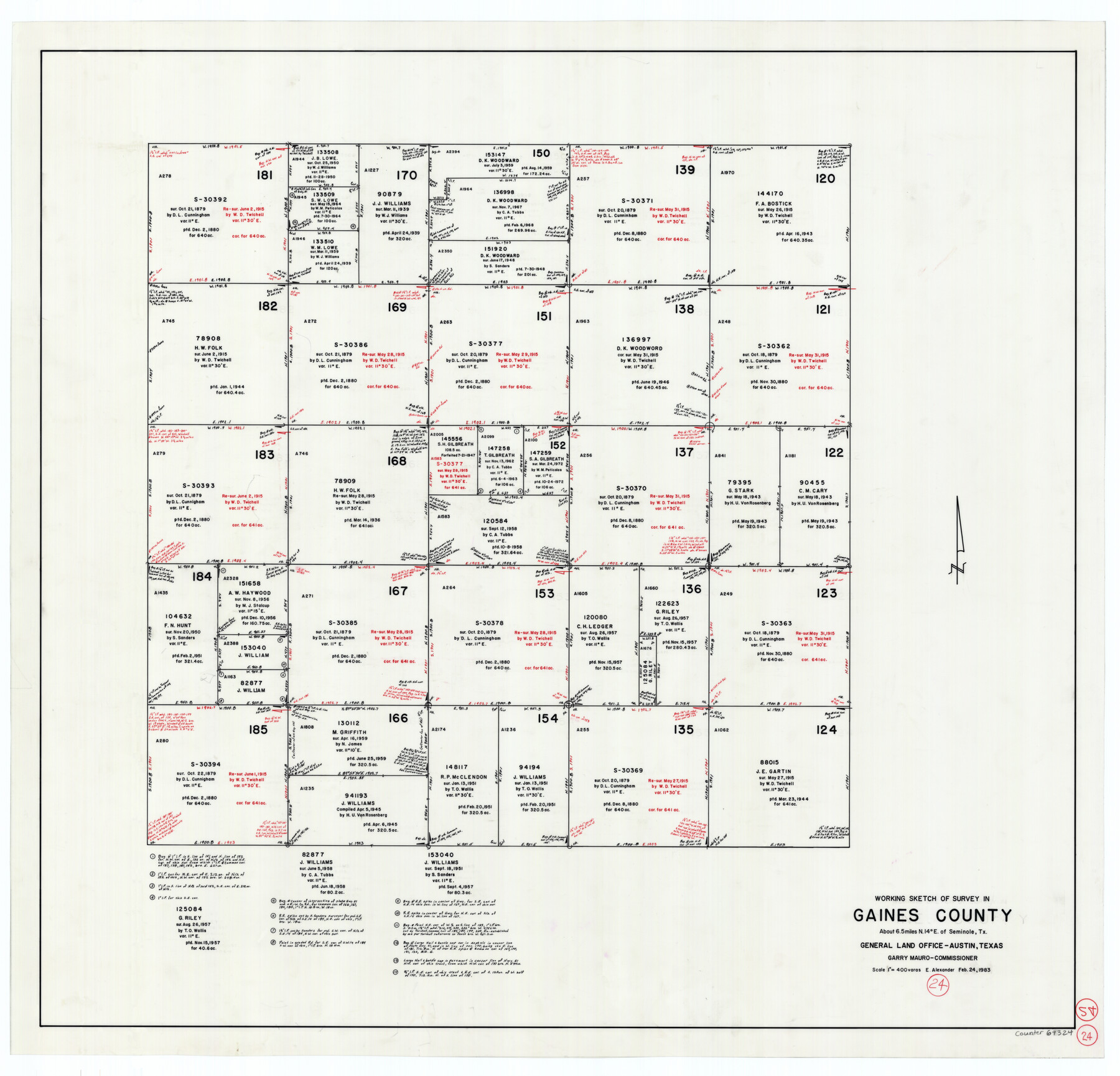
Gaines County Working Sketch 24
-
Map/Doc
69324
-
Collection
General Map Collection
-
Object Dates
2/24/1983 (Creation Date)
-
People and Organizations
Earl Alexander (Draftsman)
-
Counties
Gaines
-
Subjects
Surveying Working Sketch
-
Height x Width
36.4 x 37.9 inches
92.5 x 96.3 cm
-
Scale
1" = 400 varas
Part of: General Map Collection
Swisher County Boundary File 1

Print $72.00
- Digital $50.00
Swisher County Boundary File 1
Size 9.0 x 4.5 inches
Map/Doc 59075
Wood County Working Sketch 2

Print $20.00
- Digital $50.00
Wood County Working Sketch 2
1913
Size 17.8 x 16.8 inches
Map/Doc 62002
Sutton County Sketch File 56

Print $8.00
Sutton County Sketch File 56
1953
Size 11.2 x 9.0 inches
Map/Doc 37538
Map of Ferguson State Farm, Madison County, Texas

Print $20.00
- Digital $50.00
Map of Ferguson State Farm, Madison County, Texas
Size 21.6 x 26.1 inches
Map/Doc 62989
Denton County Boundary File 4 and 4a and 4b and 4c

Print $2.00
- Digital $50.00
Denton County Boundary File 4 and 4a and 4b and 4c
Size 11.0 x 8.7 inches
Map/Doc 52470
Burnet County Sketch File 37

Print $2.00
- Digital $50.00
Burnet County Sketch File 37
1935
Size 10.1 x 8.2 inches
Map/Doc 16754
Nueces County Working Sketch 4

Print $20.00
- Digital $50.00
Nueces County Working Sketch 4
1951
Size 46.8 x 36.2 inches
Map/Doc 71306
Travis County Rolled Sketch 58

Print $20.00
- Digital $50.00
Travis County Rolled Sketch 58
Size 37.4 x 25.5 inches
Map/Doc 8049
Gaines County Sketch File 6

Print $20.00
- Digital $50.00
Gaines County Sketch File 6
1924
Size 20.9 x 21.3 inches
Map/Doc 11523
![94161, Austin and Vicinity [Verso], General Map Collection](https://historictexasmaps.com/wmedia_w700/maps/94161.tif.jpg)
Edwards County Sketch File 32 1/2

Print $6.00
- Digital $50.00
Edwards County Sketch File 32 1/2
Size 11.4 x 17.4 inches
Map/Doc 21767
Potter County Rolled Sketch 3

Print $20.00
- Digital $50.00
Potter County Rolled Sketch 3
1892
Map/Doc 9758
You may also like
Matagorda County Rolled Sketch 24

Print $40.00
- Digital $50.00
Matagorda County Rolled Sketch 24
1945
Size 53.2 x 29.6 inches
Map/Doc 9478
English Field Notes of the Spanish Archives - Books TJG, DB, A, A2, B, B2, WB, and WR

English Field Notes of the Spanish Archives - Books TJG, DB, A, A2, B, B2, WB, and WR
1835
Map/Doc 96553
General Chart of the Coast No. XVI - Gulf Coast from Galveston to the Rio Grande

Print $20.00
- Digital $50.00
General Chart of the Coast No. XVI - Gulf Coast from Galveston to the Rio Grande
1883
Size 26.8 x 18.1 inches
Map/Doc 72737
Medina County Working Sketch 5

Print $20.00
- Digital $50.00
Medina County Working Sketch 5
1949
Size 38.5 x 37.3 inches
Map/Doc 70920
Flight Mission No. DQN-5K, Frame 24, Calhoun County

Print $20.00
- Digital $50.00
Flight Mission No. DQN-5K, Frame 24, Calhoun County
1953
Size 18.5 x 22.1 inches
Map/Doc 84375
Amistad International Reservoir on Rio Grande 105

Print $20.00
- Digital $50.00
Amistad International Reservoir on Rio Grande 105
1950
Size 28.5 x 40.8 inches
Map/Doc 75536
Refugio County Sketch File 24

Print $12.00
- Digital $50.00
Refugio County Sketch File 24
1954
Size 14.4 x 8.9 inches
Map/Doc 35283
[Blocks C31-C37, D, D1, DD and vicinity]
![91870, [Blocks C31-C37, D, D1, DD and vicinity], Twichell Survey Records](https://historictexasmaps.com/wmedia_w700/maps/91870-1.tif.jpg)
Print $20.00
- Digital $50.00
[Blocks C31-C37, D, D1, DD and vicinity]
Size 21.1 x 15.3 inches
Map/Doc 91870
Floyd County Sketch File 24

Print $6.00
- Digital $50.00
Floyd County Sketch File 24
1915
Size 9.0 x 14.5 inches
Map/Doc 22780
Wise County Sketch File 13

Print $4.00
- Digital $50.00
Wise County Sketch File 13
Size 9.0 x 15.2 inches
Map/Doc 40546
Coast Chart No. 210 - Aransas Pass and Corpus Christi Bay with the coast to latitude 27° 12', Texas

Print $20.00
- Digital $50.00
Coast Chart No. 210 - Aransas Pass and Corpus Christi Bay with the coast to latitude 27° 12', Texas
1900
Size 18.3 x 23.6 inches
Map/Doc 73448
Galveston County Rolled Sketch 27

Print $20.00
- Digital $50.00
Galveston County Rolled Sketch 27
1978
Size 29.6 x 33.3 inches
Map/Doc 10301